
Seller's Agent in 2026
Drayton Lassen
RE/MAX
(843) 687-4295
95 Total Sales
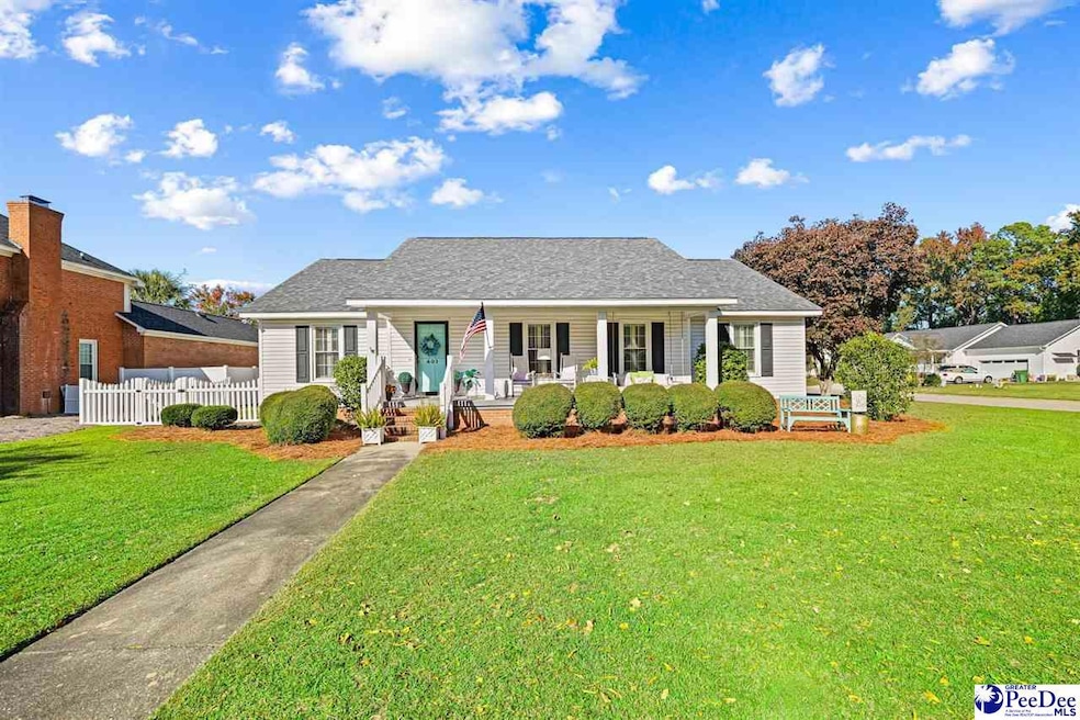


Welcome to 401 Sidney Avenue — a beautifully maintained 3-bedroom, 2-bath home in one of Florence’s most charming and convenient neighborhoods. Offering 1,746 square feet of comfortable living space, this property sits proudly on a landscaped corner lot, giving it wonderful curb appeal and an inviting presence from the moment you arrive. Step inside and you’ll immediately appreciate the easy, entertaining-friendly flow of the home. The oversized living room is a true focal point, featuring vaulted ceilings, abundant natural light, and a cozy gas log fireplace—perfect for gathering with friends and family. The spacious eat-in kitchen provides plenty of room for casual meals, while the formal dining room offers an ideal setting for holidays and special occasions. All three bedrooms are well-sized, and the two full baths are conveniently located for both residents and guests. Outside, the property continues to impress with a fantastic fenced-in backyard, ideal for pets, play, or outdoor entertaining. The double carport with a large storage room adds even more convenience, providing ample space for tools, lawn equipment, or hobby storage. With its functionality, charm, and great location, 401 Sydney Avenue is truly a place to call home. Don’t miss your chance to see this one!
Last Agent to Sell the Property
Re/max Professionals License #90169 Listed on: 11/26/2025
| Date | Type | Sale Price | Title Company |
|---|---|---|---|
| Warranty Deed | $270,000 | None Listed On Document | |
| Deed | $167,000 | -- |
| Date | Status | Loan Amount | Loan Type |
|---|---|---|---|
| Open | $214,200 | New Conventional | |
| Previous Owner | $147,000 | New Conventional |
| Date | Event | Price | List to Sale | Price per Sq Ft |
|---|---|---|---|---|
| 01/05/2026 01/05/26 | Sold | $270,000 | -3.2% | $155 / Sq Ft |
| 11/30/2025 11/30/25 | Off Market | $279,000 | -- | -- |
| 11/26/2025 11/26/25 | For Sale | $279,000 | -- | $160 / Sq Ft |
| Year | Tax Paid | Tax Assessment Tax Assessment Total Assessment is a certain percentage of the fair market value that is determined by local assessors to be the total taxable value of land and additions on the property. | Land | Improvement |
|---|---|---|---|---|
| 2025 | $978 | $9,148 | $1,200 | $7,948 |
| 2024 | $785 | $9,148 | $1,200 | $7,948 |
| 2023 | $709 | $6,664 | $1,200 | $5,464 |
| 2022 | $802 | $6,664 | $1,200 | $5,464 |
| 2021 | $871 | $6,660 | $0 | $0 |
| 2020 | $783 | $6,660 | $0 | $0 |
| 2019 | $730 | $6,664 | $1,200 | $5,464 |
| 2018 | $690 | $6,660 | $0 | $0 |
| 2017 | $654 | $6,660 | $0 | $0 |
| 2016 | $607 | $6,660 | $0 | $0 |
| 2015 | $572 | $6,010 | $0 | $0 |
| 2014 | $494 | $6,010 | $1,200 | $4,810 |
Seller's Agent in 2026
Drayton Lassen
RE/MAX
(843) 687-4295
95 Total Sales
Source: Pee Dee REALTOR® Association
MLS Number: 20254443
APN: 01505-01-027
Disclaimer: Certain information contained herein is derived from information provided by parties other than Homes.com. All information provided is deemed reliable, but is not guaranteed to be accurate and should be independently verified.
![]() IDX information is provided exclusively for personal, non-commercial use, and may not be used for any purpose other than to identify prospective properties consumers may be interested in purchasing. Information is deemed reliable but not guaranteed.
IDX information is provided exclusively for personal, non-commercial use, and may not be used for any purpose other than to identify prospective properties consumers may be interested in purchasing. Information is deemed reliable but not guaranteed.
Ask me questions while you tour the home.