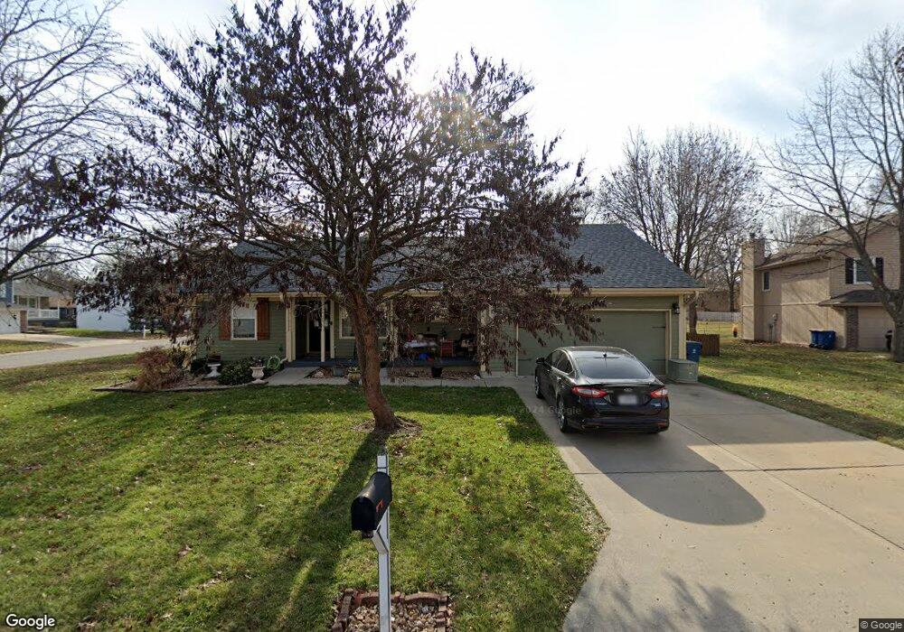
401 W 18th Cir Kearney, MO 64060
Estimated Value: $289,857 - $336,000
3
Beds
2
Baths
1,335
Sq Ft
$232/Sq Ft
Est. Value
About This Home
This home is located at 401 W 18th Cir, Kearney, MO 64060 and is currently estimated at $309,214, approximately $231 per square foot. 401 W 18th Cir is a home located in Clay County with nearby schools including Kearney Junior High School and Kearney High School.
Ownership History
Date
Name
Owned For
Owner Type
Purchase Details
Closed on
Sep 7, 2001
Sold by
Lowrey Robert D
Bought by
Lowrey Stephanie M
Current Estimated Value
Purchase Details
Closed on
Feb 27, 1998
Sold by
Bonsmann David Paul and Bonsmann Phyllis Ann
Bought by
Lowrey Robert D and Lowrey Stephanie M
Home Financials for this Owner
Home Financials are based on the most recent Mortgage that was taken out on this home.
Original Mortgage
$98,940
Outstanding Balance
$18,871
Interest Rate
7.5%
Estimated Equity
$290,343
Purchase Details
Closed on
Jan 6, 1997
Sold by
Nelson Rosalie F
Bought by
Bonsman David Paul and Bonsmann Phyllis Ann
Home Financials for this Owner
Home Financials are based on the most recent Mortgage that was taken out on this home.
Original Mortgage
$85,000
Interest Rate
7.53%
Create a Home Valuation Report for This Property
The Home Valuation Report is an in-depth analysis detailing your home's value as well as a comparison with similar homes in the area
Home Values in the Area
Average Home Value in this Area
Purchase History
We collect this data history from publicly available records. To have your information removed, we recommend requesting removal directly through your county’s website.
| Date | Buyer | Sale Price | Title Company |
|---|---|---|---|
| Lowrey Stephanie M | -- | First American Title Ins Co | |
| Lowrey Robert D | -- | Thomson Title Corp | |
| Bonsman David Paul | -- | -- |
Source: Public Records
Mortgage History
We collect this data history from publicly available records. To have your information removed, we recommend requesting removal directly through your county’s website.
| Date | Status | Borrower | Loan Amount |
|---|---|---|---|
| Open | Lowrey Robert D | $98,940 | |
| Previous Owner | Bonsman David Paul | $85,000 |
Source: Public Records
Tax History
| Year | Tax Paid | Tax Assessment Tax Assessment Total Assessment is a certain percentage of the fair market value that is determined by local assessors to be the total taxable value of land and additions on the property. | Land | Improvement |
|---|---|---|---|---|
| 2025 | $2,613 | $42,710 | -- | -- |
| 2024 | $2,613 | $38,130 | -- | -- |
| 2023 | $2,604 | $38,130 | $0 | $0 |
| 2022 | $2,291 | $32,430 | $0 | $0 |
| 2021 | $2,245 | $32,433 | $3,800 | $28,633 |
| 2020 | $2,219 | $29,150 | $0 | $0 |
| 2019 | $2,207 | $29,150 | $0 | $0 |
| 2018 | $2,108 | $26,890 | $0 | $0 |
| 2017 | $2,086 | $26,880 | $3,800 | $23,080 |
| 2016 | $2,086 | $26,880 | $3,800 | $23,080 |
| 2015 | $2,086 | $26,880 | $3,800 | $23,080 |
| 2014 | $2,016 | $25,860 | $4,180 | $21,680 |
Source: Public Records
Map
Nearby Homes
- 1709 Park Ln
- 413 Regency Park St
- 1800 Patricia Dr
- 1845 Falcon Ct
- 1720 Paddock Dr
- 2002 Foxtail Point
- 2001 Foxtail Point
- 1404 Colony Dr
- 2104 Foxtail Dr
- 1104 Regency Dr
- 2028 Greenfield Mews
- 2318 Foxtail Dr
- 2314 Foxtail Dr
- 2317 Foxtail Dr
- 2354 Foxtail Dr
- 2326 Foxtail Dr
- 2325 Foxtail Dr
- 2312 Foxtail Dr
- 2307 Foxtail Dr
- 2305 Foxtail Dr
Your Personal Tour Guide
Ask me questions while you tour the home.