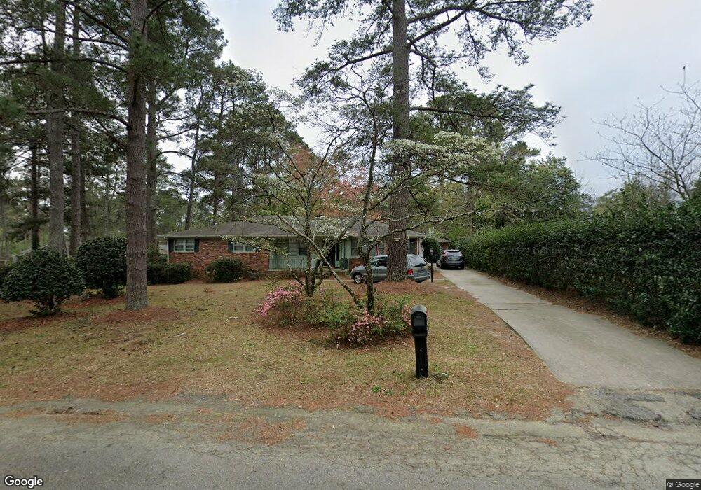
4012 Longbrook Rd Columbia, SC 29206
Estimated Value: $289,000 - $340,000
4
Beds
3
Baths
2,018
Sq Ft
$156/Sq Ft
Est. Value
About This Home
This home is located at 4012 Longbrook Rd, Columbia, SC 29206 and is currently estimated at $314,280, approximately $155 per square foot. 4012 Longbrook Rd is a home located in Richland County with nearby schools including Forest Lake Elementary School, Dent Middle School, and Richland Northeast High School.
Ownership History
Date
Name
Owned For
Owner Type
Purchase Details
Closed on
Dec 21, 2011
Sold by
Thomas Sidney F
Bought by
Dunleavy Timothy R and Dunleavy Stacy D
Current Estimated Value
Home Financials for this Owner
Home Financials are based on the most recent Mortgage that was taken out on this home.
Original Mortgage
$139,691
Outstanding Balance
$97,329
Interest Rate
4.4%
Mortgage Type
FHA
Estimated Equity
$216,951
Purchase Details
Closed on
Oct 20, 2009
Sold by
Estate Of Jean C Thomas
Bought by
Thomas Sidney F
Purchase Details
Closed on
Mar 6, 2009
Sold by
Thomas Jean C
Bought by
Thomas Sidney F and Thomas Jean C
Create a Home Valuation Report for This Property
The Home Valuation Report is an in-depth analysis detailing your home's value as well as a comparison with similar homes in the area
Home Values in the Area
Average Home Value in this Area
Purchase History
| Date | Buyer | Sale Price | Title Company |
|---|---|---|---|
| Dunleavy Timothy R | $143,325 | -- | |
| Thomas Sidney F | -- | -- | |
| Thomas Sidney F | -- | -- |
Source: Public Records
Mortgage History
| Date | Status | Borrower | Loan Amount |
|---|---|---|---|
| Open | Dunleavy Timothy R | $139,691 |
Source: Public Records
Tax History Compared to Growth
Tax History
| Year | Tax Paid | Tax Assessment Tax Assessment Total Assessment is a certain percentage of the fair market value that is determined by local assessors to be the total taxable value of land and additions on the property. | Land | Improvement |
|---|---|---|---|---|
| 2024 | $1,635 | $179,300 | $0 | $0 |
| 2023 | $1,635 | $6,236 | $0 | $0 |
| 2022 | $1,438 | $155,900 | $31,000 | $124,900 |
| 2021 | $1,455 | $6,240 | $0 | $0 |
| 2020 | $1,489 | $6,240 | $0 | $0 |
| 2019 | $1,503 | $6,240 | $0 | $0 |
| 2018 | $1,576 | $6,360 | $0 | $0 |
| 2017 | $1,544 | $6,360 | $0 | $0 |
| 2016 | $1,525 | $6,360 | $0 | $0 |
| 2015 | $1,551 | $6,360 | $0 | $0 |
| 2014 | $1,348 | $144,300 | $0 | $0 |
| 2013 | -- | $5,770 | $0 | $0 |
Source: Public Records
Map
Nearby Homes
- 6715 Eastbrook Rd
- 3611 Boundbrook Ln
- 6515 Whiteoak Rd
- 124 Mayhaw Dr
- 330 Arcadia Lakes Dr E
- 116 Mayhaw Dr
- 129 Mayhaw Dr
- 0 Mayhaw Dr
- 6346 Goldbranch Rd
- 6342 Westshore Rd
- 6315 Goldbranch Rd
- 6715 N Trenholm Rd
- 6923 Wedgefield Rd
- 6409 N Trenholm Rd
- 1117 Palisades Cir
- Nx Northshore Rd
- 19 Ashworth Ln
- 6329 Pinefield Rd
- 6905 Cleaton Dr Unit J151
- 123 Arcadia Springs Cir
- 6576 Eastshore Rd
- 6533 Sandale Dr
- 6570 Eastshore Rd
- 6529 Sandale Dr
- 6564 Eastshore Rd
- 6601 Eastbrook Rd
- 6525 Sandale Dr
- 6600 Brookfield Rd
- 6515 Sandale Dr
- 6509 Sandale Dr
- 6607 Eastbrook Rd
- 6604 Brookfield Rd
- 6503 Sandale Dr
- 6575 Eastshore Rd
- 6532 Sandale Dr
- 6528 Sandale Dr
- 6569 Eastshore Rd
- 6600 Eastbrook Rd
- 6524 Sandale Dr
- 3921 Longbrook Rd