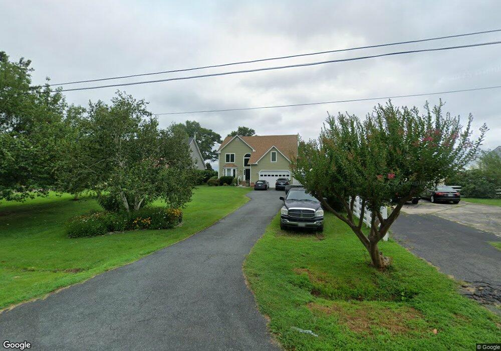
402 Beachside Dr Stevensville, MD 21666
Estimated Value: $954,000 - $1,319,000
Studio
2
Baths
2,771
Sq Ft
$391/Sq Ft
Est. Value
About This Home
This home is located at 402 Beachside Dr, Stevensville, MD 21666 and is currently estimated at $1,084,387, approximately $391 per square foot. 402 Beachside Dr is a home located in Queen Anne's County with nearby schools including Matapeake Elementary School, Matapeake Middle School, and Kent Island High School.
Ownership History
Date
Name
Owned For
Owner Type
Purchase Details
Closed on
Dec 31, 2019
Sold by
Lafferty John Frederic and Lafferty Nanciemarie Mccusker
Bought by
Lafferty John F and Lafferty Nanciemarie M
Current Estimated Value
Purchase Details
Closed on
May 2, 2003
Sold by
Lafferty John and Lafferty Nancie Marie
Bought by
Lafferty Lafferty John Frederic John Frederic and Lafferty Nanciemarie Mccusker
Purchase Details
Closed on
May 13, 1998
Sold by
Glandon Elizabeth H
Bought by
Lafferty John and Lafferty Nancie Marie
Purchase Details
Closed on
Feb 24, 1987
Sold by
Miles James D
Bought by
Glandon Elizabeth H and Glandon John S
Create a Home Valuation Report for This Property
The Home Valuation Report is an in-depth analysis detailing your home's value as well as a comparison with similar homes in the area
Purchase History
| Date | Buyer | Sale Price | Title Company |
|---|---|---|---|
| Lafferty John F | -- | None Available | |
| Lafferty Lafferty John Frederic John Frederic | -- | -- | |
| Lafferty John | $170,000 | -- | |
| Glandon Elizabeth H | $115,000 | -- |
Source: Public Records
Mortgage History
| Date | Status | Borrower | Loan Amount |
|---|---|---|---|
| Closed | Lafferty John | -- |
Source: Public Records
Tax History
| Year | Tax Paid | Tax Assessment Tax Assessment Total Assessment is a certain percentage of the fair market value that is determined by local assessors to be the total taxable value of land and additions on the property. | Land | Improvement |
|---|---|---|---|---|
| 2025 | $6,578 | $859,767 | $0 | $0 |
| 2024 | $6,228 | $742,933 | $0 | $0 |
| 2023 | $5,898 | $626,100 | $390,000 | $236,100 |
| 2022 | $5,958 | $626,100 | $390,000 | $236,100 |
| 2021 | $6,539 | $626,100 | $390,000 | $236,100 |
| 2020 | $6,539 | $675,500 | $464,000 | $211,500 |
| 2019 | $6,317 | $652,333 | $0 | $0 |
| 2018 | $6,094 | $629,167 | $0 | $0 |
| 2017 | $5,872 | $606,000 | $0 | $0 |
| 2016 | -- | $606,000 | $0 | $0 |
| 2015 | $2,749 | $606,000 | $0 | $0 |
| 2014 | $2,749 | $659,100 | $0 | $0 |
Source: Public Records
Map
Nearby Homes
- 312 S Lake Dr
- 101 Beachside Dr
- 208 Tower Dr
- 145 N Lake Dr
- 114 N Lake Dr
- 118 N Lake Dr
- 200 Mallard Cove Ln
- 306 N Lake Rd
- Lot 1 - E/Kent Point Romancoke
- 610 Elm St
- 0 Ackerman Dr
- Lot 8 Ackerman Dr
- 217 Ackerman Dr
- 205 Lighthouse View Dr
- 414 Bay Dr
- 137 Tanners Point Dr
- 102 Golf Ct
- 346 Oregon Rd
- 224 Long Point Rd
- 109 Carroll Rd
- 400 Beachside Dr
- 404 Beachside Dr
- 324 Beachside Dr
- 406 Beachside Dr
- 322 Beachside Dr
- 408 Beachside Dr
- 401 Beachside Dr
- 317 Beachside Dr
- 410 Beachside Dr
- 318 Beachside Dr
- 315 Beachside Dr
- 412 Beachside Dr
- 316 Drovers Way
- 414 Beachside Dr
- 316 Beachside Dr
- 313 Beachside Dr
- 314 Drovers Way
- 416 Beachside Dr
- 312 Drovers Way
- 309 Beachside Dr