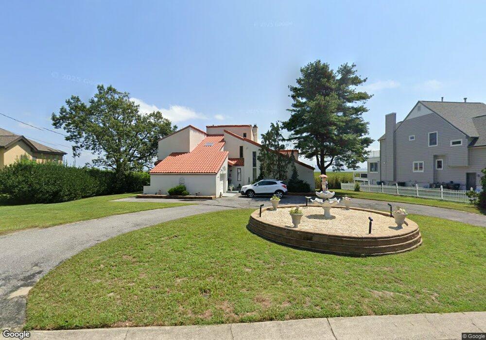
402 Burning Tree Blvd Absecon, NJ 08201
Estimated Value: $647,671 - $820,000
Studio
--
Bath
3,248
Sq Ft
$218/Sq Ft
Est. Value
About This Home
This home is located at 402 Burning Tree Blvd, Absecon, NJ 08201 and is currently estimated at $707,418, approximately $217 per square foot. 402 Burning Tree Blvd is a home located in Atlantic County with nearby schools including H. Ashton Marsh Elementary School, Emma C. Attales Middle School, and Life Point Academy/ Life Point Church.
Ownership History
Date
Name
Owned For
Owner Type
Purchase Details
Closed on
Sep 29, 2004
Sold by
Rivenbark Stuart
Bought by
Decarlo Thomas
Current Estimated Value
Home Financials for this Owner
Home Financials are based on the most recent Mortgage that was taken out on this home.
Original Mortgage
$437,000
Interest Rate
7.99%
Mortgage Type
Purchase Money Mortgage
Purchase Details
Closed on
Jan 15, 1997
Sold by
Saseen A Richard
Bought by
Hart Destinee
Home Financials for this Owner
Home Financials are based on the most recent Mortgage that was taken out on this home.
Original Mortgage
$207,000
Interest Rate
7.57%
Mortgage Type
Balloon
Purchase Details
Closed on
Jan 10, 1997
Sold by
Saseen Maureen W
Bought by
Saseen A Richard
Home Financials for this Owner
Home Financials are based on the most recent Mortgage that was taken out on this home.
Original Mortgage
$207,000
Interest Rate
7.57%
Mortgage Type
Balloon
Create a Home Valuation Report for This Property
The Home Valuation Report is an in-depth analysis detailing your home's value as well as a comparison with similar homes in the area
Home Values in the Area
Average Home Value in this Area
Purchase History
| Date | Buyer | Sale Price | Title Company |
|---|---|---|---|
| Decarlo Thomas | $460,000 | -- | |
| Decarlo Thomas | $460,000 | -- | |
| Decarlo Thomas | $460,000 | -- | |
| Hart Destinee | $262,500 | The Title Company | |
| Saseen A Richard | -- | -- |
Source: Public Records
Mortgage History
| Date | Status | Borrower | Loan Amount |
|---|---|---|---|
| Previous Owner | Decarlo Thomas | $437,000 | |
| Previous Owner | Hart Destinee | $207,000 |
Source: Public Records
Tax History
| Year | Tax Paid | Tax Assessment Tax Assessment Total Assessment is a certain percentage of the fair market value that is determined by local assessors to be the total taxable value of land and additions on the property. | Land | Improvement |
|---|---|---|---|---|
| 2025 | $11,949 | $357,100 | $130,400 | $226,700 |
| 2024 | $11,866 | $357,100 | $130,400 | $226,700 |
Source: Public Records
Map
Nearby Homes
- 202 Burning Tree Blvd
- 172 E Faunce Landing Rd
- 194 N Shore Rd
- 40 N Shore Rd
- 11 Lisbon Ave
- 36 E Lee Ave
- 161 E Wyoming Ave
- 107 W Church St
- 15 W Bolton Ave
- 175 New Jersey Ave
- 14 Kesler Ave
- 4 E Curran Dr
- 236 E Wyoming Ave
- 399 Pitney Rd
- 1513 Ocean Ave
- 1508 7th Ave
- 1427 Ocean Ave
- 130 Davis Ave
- 123 Bayview Dr
- 1403 N Franklin Blvd
- 404 Burning Tree Blvd
- 400 Burning Tree Blvd
- 503 Burning Tree Blvd
- 403 Burning Tree Blvd
- 401 Burning Tree Blvd
- 407 Burning Tree Blvd
- 408 Burning Tree Blvd
- 399 Burning Tree Blvd
- 404 Cynwyd Dr
- 402 Cynwyd Dr
- 719 Birch Cir
- 406 Cynwyd Dr
- 111 Cedar Hill Dr
- 410 Burning Tree Blvd
- 308 Cynwyd Dr
- 305 Burning Tree Blvd
- 302 Burning Tree Blvd
- 408 Cynwyd Dr
- 306 Cynwyd Dr
- 403 Cynwyd Dr
Your Personal Tour Guide
Ask me questions while you tour the home.