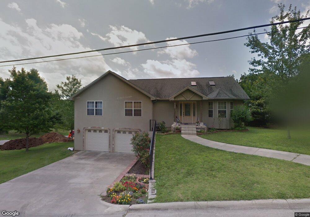
402 Cedar St Branson, MO 65616
West Branson NeighborhoodEstimated Value: $287,000 - $510,000
Studio
--
Bath
1,736
Sq Ft
$213/Sq Ft
Est. Value
About This Home
This home is located at 402 Cedar St, Branson, MO 65616 and is currently estimated at $368,910, approximately $212 per square foot. 402 Cedar St is a home located in Taney County with nearby schools including Cedar Ridge Primary, Cedar Ridge Intermediate School, and Cedar Ridge Elementary School.
Ownership History
Date
Name
Owned For
Owner Type
Purchase Details
Closed on
Aug 16, 2012
Sold by
Hayes Matthew C and Hayes Cassandra
Bought by
Hayes Matthew C and Hayes Cassandra
Current Estimated Value
Home Financials for this Owner
Home Financials are based on the most recent Mortgage that was taken out on this home.
Original Mortgage
$190,700
Outstanding Balance
$131,859
Interest Rate
3.63%
Mortgage Type
New Conventional
Estimated Equity
$237,051
Purchase Details
Closed on
Apr 11, 2006
Sold by
Wilson Linda D
Bought by
Madrid Bernardo U
Create a Home Valuation Report for This Property
The Home Valuation Report is an in-depth analysis detailing your home's value as well as a comparison with similar homes in the area
Home Values in the Area
Average Home Value in this Area
Purchase History
| Date | Buyer | Sale Price | Title Company |
|---|---|---|---|
| Hayes Matthew C | -- | Great American Title | |
| Madrid Bernardo U | -- | -- |
Source: Public Records
Mortgage History
| Date | Status | Borrower | Loan Amount |
|---|---|---|---|
| Open | Hayes Matthew C | $190,700 |
Source: Public Records
Tax History
| Year | Tax Paid | Tax Assessment Tax Assessment Total Assessment is a certain percentage of the fair market value that is determined by local assessors to be the total taxable value of land and additions on the property. | Land | Improvement |
|---|---|---|---|---|
| 2025 | $1,775 | $28,910 | -- | -- |
| 2023 | $1,775 | $33,190 | $0 | $0 |
| 2022 | $1,726 | $33,190 | $0 | $0 |
| 2021 | $1,715 | $33,190 | $0 | $0 |
| 2019 | $1,524 | $28,270 | $0 | $0 |
| 2018 | $1,525 | $28,270 | $0 | $0 |
| 2017 | $1,510 | $28,270 | $0 | $0 |
| 2016 | $1,691 | $31,730 | $0 | $0 |
| 2015 | $1,675 | $31,730 | $0 | $0 |
| 2014 | $1,526 | $30,310 | $0 | $0 |
Source: Public Records
Map
Nearby Homes
- 667 Henderson St
- 745 Aaron Way
- 119 Grand Mountain Ave
- 108 Garden Cir Unit 104-3
- 220 Harmony Ln
- 103 Garden Cir Unit 4
- 237 Dakota Rd
- 301 Dakota Rd
- 132 Rock Candy Ln Unit 1
- 133 Rock Candy Ln
- 135 Rock Candy Ln
- 237 Oakridge Rd Unit 2
- 239 Oakridge Rd Unit 237/239
- 239 Oakridge Rd Unit 1
- 316 Summer Dr
- 228 Oakridge Rd
- 238 Oakridge Rd
- 264 Oakridge Rd
- 2800 Green Mountain Dr Unit 111 B & C
- 2800 Green Mountain Dr Unit 112 B & C
Your Personal Tour Guide
Ask me questions while you tour the home.