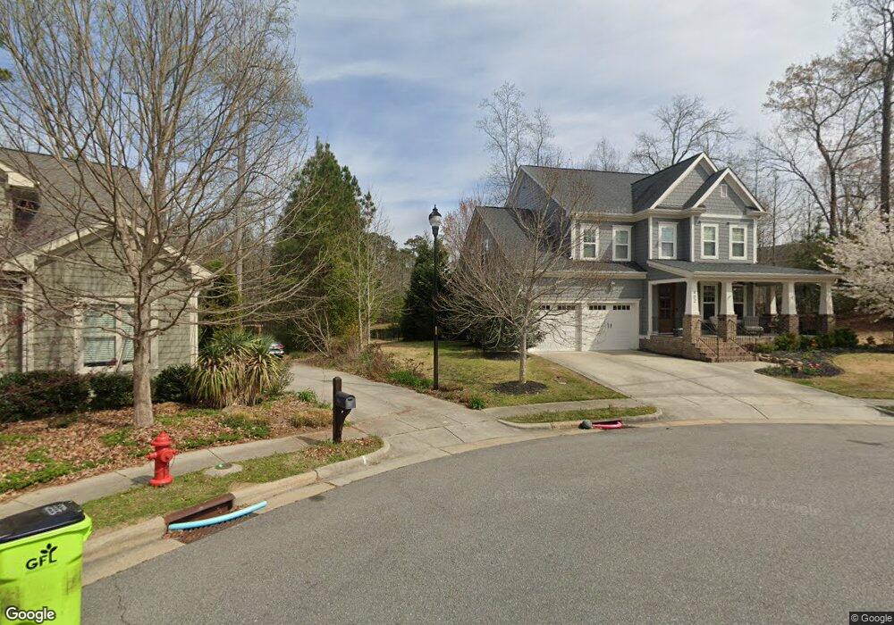
402 Dark Forest Dr Chapel Hill, NC 27516
Estimated Value: $783,824 - $949,000
5
Beds
3
Baths
2,778
Sq Ft
$302/Sq Ft
Est. Value
About This Home
This home is located at 402 Dark Forest Dr, Chapel Hill, NC 27516 and is currently estimated at $839,956, approximately $302 per square foot. 402 Dark Forest Dr is a home located in Chatham County with nearby schools including Margaret B. Pollard Middle School and Woods Charter.
Ownership History
Date
Name
Owned For
Owner Type
Purchase Details
Closed on
Jul 31, 2012
Sold by
Homes By Dickerson Inc
Bought by
Winters Timothy and Winters Patricia
Current Estimated Value
Home Financials for this Owner
Home Financials are based on the most recent Mortgage that was taken out on this home.
Original Mortgage
$396,700
Outstanding Balance
$271,620
Interest Rate
3.25%
Mortgage Type
Construction
Estimated Equity
$568,336
Create a Home Valuation Report for This Property
The Home Valuation Report is an in-depth analysis detailing your home's value as well as a comparison with similar homes in the area
Home Values in the Area
Average Home Value in this Area
Purchase History
| Date | Buyer | Sale Price | Title Company |
|---|---|---|---|
| Winters Timothy | $60,000 | None Available | |
| Hoomes By Dickerson Inc | $75,000 | None Available |
Source: Public Records
Mortgage History
| Date | Status | Borrower | Loan Amount |
|---|---|---|---|
| Open | Hoomes By Dickerson Inc | $396,700 | |
| Closed | Winters Timothy | $396,700 |
Source: Public Records
Tax History
| Year | Tax Paid | Tax Assessment Tax Assessment Total Assessment is a certain percentage of the fair market value that is determined by local assessors to be the total taxable value of land and additions on the property. | Land | Improvement |
|---|---|---|---|---|
| 2025 | $5,557 | $769,179 | $144,000 | $625,179 |
| 2024 | $5,557 | $541,566 | $115,200 | $426,366 |
| 2023 | $4,757 | $541,566 | $115,200 | $426,366 |
| 2022 | $4,365 | $541,566 | $115,200 | $426,366 |
| 2021 | $4,311 | $541,566 | $115,200 | $426,366 |
| 2020 | $3,918 | $487,578 | $90,000 | $397,578 |
| 2019 | $3,918 | $487,578 | $90,000 | $397,578 |
| 2018 | $3,656 | $487,578 | $90,000 | $397,578 |
| 2017 | $3,656 | $487,578 | $90,000 | $397,578 |
| 2016 | $2,841 | $373,259 | $90,000 | $283,259 |
| 2015 | $2,797 | $373,259 | $90,000 | $283,259 |
| 2014 | $2,741 | $373,259 | $90,000 | $283,259 |
| 2013 | -- | $344,934 | $90,000 | $254,934 |
Source: Public Records
Map
Nearby Homes
- 1168 Great Ridge Pkwy
- 85 Saxapahaw Run
- 41 N Serenity Hill Cir
- 38 Owen Towne Rd
- 156 Serenity Hill Cir
- 22 Treywood Ln
- 646 Great Ridge Pkwy
- 540 Patterson Dr
- 614 Great Ridge Pkwy
- 676 Tobacco Farm Way
- 700 Tobacco Farm Way
- 560 Great Ridge Pkwy
- 39 Monteith Dr
- 17 Monteith Dr
- 366 Old Piedmont Cir
- 254 Deardom Way
- 361 Old Piedmont Cir
- 1980 Great Ridge Pkwy
- 132 Deardom Way
- 504 Beacon Ridge Blvd
- 384 Dark Forest Dr
- 414 Dark Forest Dr
- 672 Bennett Mountain Trace Unit LT78
- 672 Bennett Mountain Trace
- 415 Dark Forest Dr Unit LOT73
- 413 Dark Forest Dr Unit LOT72
- 413 Dark Forest Dr
- 381 Dark Forest Dr
- 393 Dark Forest Dr
- 658 Bennett Mountain Trace Unit Lot79
- 658 Bennett Mountain Trace
- 688 Bennett Mountain Trace Unit Lt77
- 688 Bennett Mountain Trace
- 353 Dark Forest Dr Unit LOT68
- 353 Dark Forest Dr
- 373 Dark Forest Dr
- 644 Bennett Mountain Trace
- 644 Bennett Mountain Trace Unit LT80
- 351 Dark Forest Dr Unit LT444
- 351 Dark Forest Dr
Your Personal Tour Guide
Ask me questions while you tour the home.