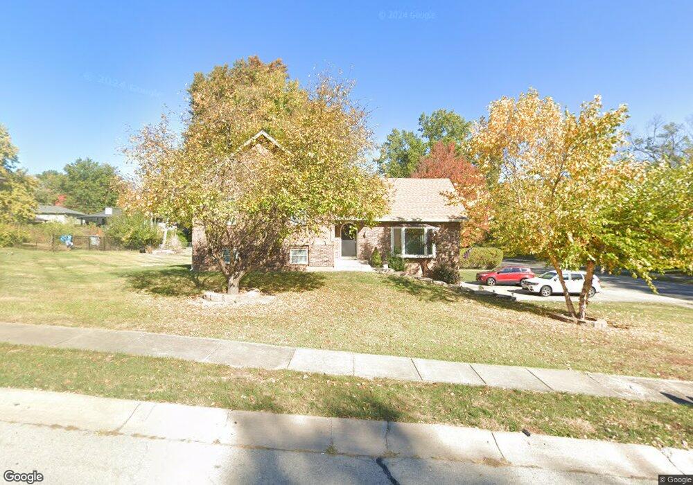
402 Kingsley Ave Liberty, MO 64068
Estimated Value: $289,000 - $350,000
4
Beds
3
Baths
1,335
Sq Ft
$233/Sq Ft
Est. Value
About This Home
This home is located at 402 Kingsley Ave, Liberty, MO 64068 and is currently estimated at $310,522, approximately $232 per square foot. 402 Kingsley Ave is a home located in Clay County with nearby schools including Alexander Doniphan Elementary School, Discovery Middle School, and Liberty High School.
Ownership History
Date
Name
Owned For
Owner Type
Purchase Details
Closed on
Sep 15, 2011
Sold by
Fsb Properties L L C
Bought by
Brock Rodney L and Brock Amie L
Current Estimated Value
Home Financials for this Owner
Home Financials are based on the most recent Mortgage that was taken out on this home.
Original Mortgage
$76,800
Outstanding Balance
$52,542
Interest Rate
4.24%
Mortgage Type
New Conventional
Estimated Equity
$257,980
Purchase Details
Closed on
May 17, 2011
Sold by
Coulter Timothy P and Coulter Carole M
Bought by
Fsb Properties L L C
Create a Home Valuation Report for This Property
The Home Valuation Report is an in-depth analysis detailing your home's value as well as a comparison with similar homes in the area
Home Values in the Area
Average Home Value in this Area
Purchase History
| Date | Buyer | Sale Price | Title Company |
|---|---|---|---|
| Brock Rodney L | -- | Stewart Title Company Midwes | |
| Fsb Properties L L C | $77,693 | None Available |
Source: Public Records
Mortgage History
| Date | Status | Borrower | Loan Amount |
|---|---|---|---|
| Open | Brock Rodney L | $76,800 |
Source: Public Records
Tax History Compared to Growth
Tax History
| Year | Tax Paid | Tax Assessment Tax Assessment Total Assessment is a certain percentage of the fair market value that is determined by local assessors to be the total taxable value of land and additions on the property. | Land | Improvement |
|---|---|---|---|---|
| 2025 | $2,457 | $36,690 | -- | -- |
| 2024 | $2,457 | $31,940 | -- | -- |
| 2023 | $2,498 | $31,940 | $0 | $0 |
| 2022 | $2,294 | $28,960 | $0 | $0 |
| 2021 | $2,276 | $28,956 | $6,650 | $22,306 |
| 2020 | $2,172 | $25,950 | $0 | $0 |
| 2019 | $2,172 | $25,950 | $0 | $0 |
| 2018 | $1,990 | $23,350 | $0 | $0 |
| 2017 | $1,972 | $23,350 | $3,800 | $19,550 |
| 2016 | $1,972 | $23,350 | $3,800 | $19,550 |
| 2015 | $1,972 | $23,350 | $3,800 | $19,550 |
| 2014 | $1,905 | $22,380 | $3,800 | $18,580 |
Source: Public Records
Map
Nearby Homes
- 509 Belmont St
- 420 Belmont St
- 1507 Amesbury Ave
- 415 Monterey Ave
- 1323 Amesbury Ave
- 1733 Welleslay Ln
- Lot 2 Bent Oaks Dr
- 2116 Winding Woods Dr
- Lot 2A Oak Crest Dr
- 1124 Amesbury Ave
- 1537 Canterbury Ln
- 1218 Canterbury Ln
- 11852 N Kentucky Ave
- 918 Amesbury Ave
- 862 Amesbury Ave
- 1327 Easton Ct
- 1304 Wellington Way
- 716 Bristol Ct
- 7503 N Lewis Ave
- 7511 N Lewis Ave
- 402 Kingsley St
- 904 Wilshire Blvd
- 406 Kingsley St
- 403 Kingsley St
- 407 Kingsley St
- 410 Kingsley St
- 900 Wilshire Blvd
- 405 Pershing St
- 411 Kingsley St
- 409 Pershing St
- 414 Kingsley St
- 414 Kingsley Ave
- 2016 Clay Dr
- 415 Kingsley St
- 413 Pershing St
- 2020 Clay Dr
- 2012 Clay Dr
- 2024 Clay Dr
- 417 Pershing St
- 400 Pershing St