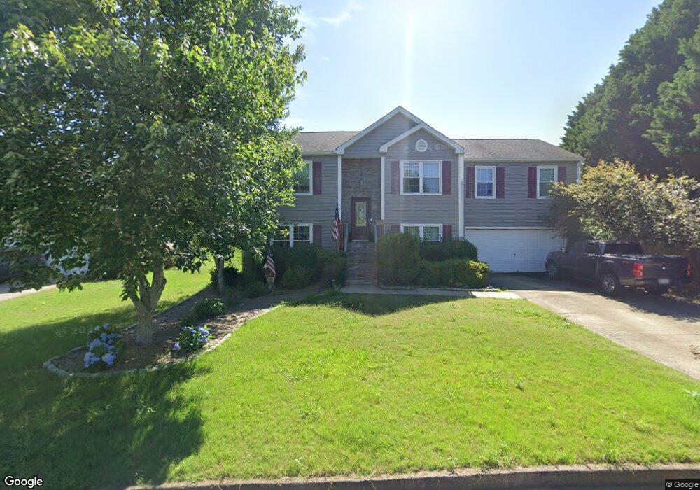
402 Plantation Way Unit 1 Woodstock, GA 30188
Union Hill NeighborhoodEstimated Value: $414,433 - $415,000
3
Beds
2
Baths
1,692
Sq Ft
$245/Sq Ft
Est. Value
About This Home
This home is located at 402 Plantation Way Unit 1, Woodstock, GA 30188 and is currently estimated at $414,717, approximately $245 per square foot. 402 Plantation Way Unit 1 is a home located in Cherokee County with nearby schools including Arnold Mill Elementary School, Mill Creek Middle School, and River Ridge High School.
Ownership History
Date
Name
Owned For
Owner Type
Purchase Details
Closed on
Jan 27, 1999
Sold by
Colony Homes Atlanta West Llc
Bought by
Davis Ii Lansil H and Davis Ii Loretta
Current Estimated Value
Home Financials for this Owner
Home Financials are based on the most recent Mortgage that was taken out on this home.
Original Mortgage
$133,350
Outstanding Balance
$31,698
Interest Rate
6.79%
Estimated Equity
$383,019
Create a Home Valuation Report for This Property
The Home Valuation Report is an in-depth analysis detailing your home's value as well as a comparison with similar homes in the area
Home Values in the Area
Average Home Value in this Area
Purchase History
| Date | Buyer | Sale Price | Title Company |
|---|---|---|---|
| Davis Ii Lansil H | $130,800 | -- |
Source: Public Records
Mortgage History
| Date | Status | Borrower | Loan Amount |
|---|---|---|---|
| Open | Davis Ii Lansil H | $133,350 |
Source: Public Records
Tax History Compared to Growth
Tax History
| Year | Tax Paid | Tax Assessment Tax Assessment Total Assessment is a certain percentage of the fair market value that is determined by local assessors to be the total taxable value of land and additions on the property. | Land | Improvement |
|---|---|---|---|---|
| 2024 | $3,450 | $144,800 | $32,000 | $112,800 |
| 2023 | $3,098 | $148,720 | $32,000 | $116,720 |
| 2022 | $3,162 | $129,356 | $27,200 | $102,156 |
| 2021 | $2,788 | $101,996 | $20,000 | $81,996 |
| 2020 | $2,652 | $93,320 | $17,200 | $76,120 |
| 2019 | $2,508 | $88,280 | $16,000 | $72,280 |
| 2018 | $2,284 | $79,880 | $16,000 | $63,880 |
| 2017 | $2,235 | $193,900 | $16,000 | $61,560 |
| 2016 | $1,958 | $168,100 | $14,400 | $52,840 |
| 2015 | $1,892 | $160,900 | $12,800 | $51,560 |
| 2014 | $1,817 | $154,200 | $12,800 | $48,880 |
Source: Public Records
Map
Nearby Homes
- 112 River Marsh Ln
- 102 River Marsh Ln
- 1038 River Plantation Dr
- 5090 Eubanks Rd
- 120 Farm Gate Dr
- 907 Andover Ct
- 516 E Cherokee Ct
- 120 Sweetbriar Farm Rd
- 427 Silver Brook Dr
- 436 Silver Brook Dr
- 217 Sweetbriar Club Dr
- 112 Sunnybrook Ln
- 4020 N Arnold Mill Rd
- 454 Silver Brook Dr
- 1350 Hendon Rd
- 2875 Trickum Rd
- 874 Keystone Dr
- 114 Thornwood Dr
- 404 Plantation Way
- 1014 River Plantation Dr
- 111 River Marsh Ln
- 115 River Marsh Ln
- 1012 River Plantation Dr
- 0 Plantation Way
- 117 River Marsh Ln
- 1018 River Plantation Dr Unit 1
- 406 Plantation Way
- 407 Plantation Way
- 119 River Marsh Ln
- 405 Plantation Way
- 1020 River Plantation Dr
- 1015 River Plantation Dr
- 1017 River Plantation Dr
- 123 River Marsh Ln
- 110 River Marsh Ln Unit 1
- 114 River Marsh Ln
- 1019 River Plantation Dr
- 1022 River Plantation Dr Unit O