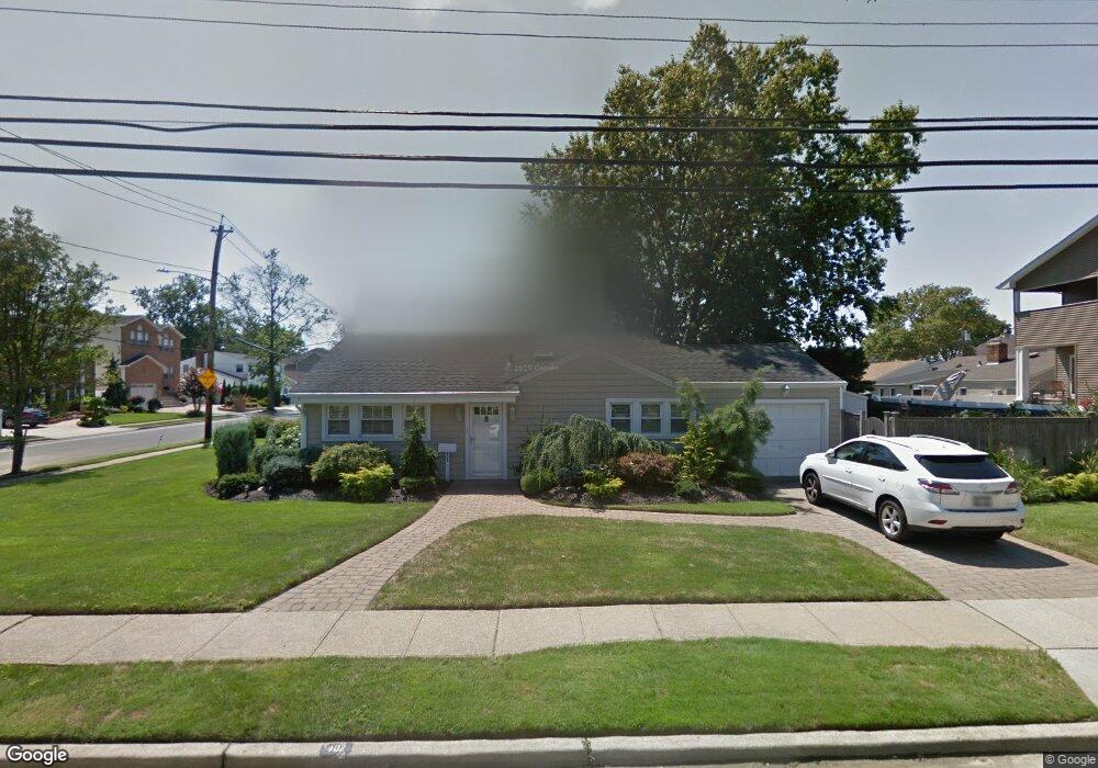
402 Wynsum Ave Merrick, NY 11566
Estimated Value: $688,277 - $821,000
--
Bed
2
Baths
1,254
Sq Ft
$602/Sq Ft
Est. Value
About This Home
This home is located at 402 Wynsum Ave, Merrick, NY 11566 and is currently estimated at $754,639, approximately $601 per square foot. 402 Wynsum Ave is a home located in Nassau County with nearby schools including Burcham Elementary School, Merrick Avenue Middle School, and John F. Kennedy High School.
Ownership History
Date
Name
Owned For
Owner Type
Purchase Details
Closed on
Jul 14, 2025
Sold by
Tauber Keith and Tauber Nancy E
Bought by
The Keith Tauber Irrevocable Trust and Tanner
Current Estimated Value
Purchase Details
Closed on
Oct 25, 2001
Sold by
Felicetti Jeffrey
Bought by
Tauber Keith
Purchase Details
Closed on
Mar 11, 1997
Sold by
Estate Truley Alice
Bought by
Felicetti Jeffrey
Create a Home Valuation Report for This Property
The Home Valuation Report is an in-depth analysis detailing your home's value as well as a comparison with similar homes in the area
Home Values in the Area
Average Home Value in this Area
Purchase History
| Date | Buyer | Sale Price | Title Company |
|---|---|---|---|
| The Keith Tauber Irrevocable Trust | -- | None Available | |
| Tauber Keith | $323,000 | Robert J Ahlstrom Jr. | |
| Tauber Keith | $323,000 | Robert J Ahlstrom Jr. | |
| Felicetti Jeffrey | $156,700 | -- | |
| Felicetti Jeffrey | $156,700 | -- |
Source: Public Records
Tax History Compared to Growth
Tax History
| Year | Tax Paid | Tax Assessment Tax Assessment Total Assessment is a certain percentage of the fair market value that is determined by local assessors to be the total taxable value of land and additions on the property. | Land | Improvement |
|---|---|---|---|---|
| 2025 | $10,217 | $445 | $255 | $190 |
| 2024 | $2,913 | $442 | $254 | $188 |
| 2023 | $9,197 | $467 | $268 | $199 |
| 2022 | $9,197 | $453 | $260 | $193 |
| 2021 | $10,885 | $455 | $261 | $194 |
| 2020 | $7,881 | $634 | $633 | $1 |
| 2019 | $8,723 | $679 | $678 | $1 |
| 2018 | $8,783 | $724 | $0 | $0 |
| 2017 | $5,798 | $770 | $602 | $168 |
| 2016 | $9,093 | $815 | $637 | $178 |
| 2015 | $3,770 | $950 | $743 | $207 |
| 2014 | $3,770 | $950 | $743 | $207 |
| 2013 | $3,567 | $950 | $743 | $207 |
Source: Public Records
Map
Nearby Homes
- 2810 Wynsum Ave
- 110 Hampton Way
- 2770 Lincoln Blvd
- 2072 Brighton Way
- 2925 Hewlett Ave
- 2956 Judith Dr
- 72 Lake End Rd
- 23 Bay St
- 2819 Harbor Rd
- 2884 Bay Dr
- 217 Bayview Ave
- 2863 Harbor Rd
- 2466 Army Place
- 1360-1370 Merrick Rd
- 2858 Shore Rd
- 2074 Ellen Dr
- 2476 Florin Ct
- 14 Bell Ct
- 163 Wynsum Ave
- 2729 Shore Dr
- 121 Brighton Way
- 398 Wynsum Ave
- 2148 Shoreham Way
- 122 Shoreham Way
- 119 Brighton Way
- 405 Wynsum Ave
- 122 Brighton Way
- 120 Shoreham Way
- 401 Wynsum Ave
- 2811 Wynsum Ave
- 120 Brighton Way
- 117 Brighton Way
- 118 Shoreham Way
- 397 Wynsum Ave
- 2828 Wynsum Ave
- 2160 Brighton Way
- 2141 Beverly Way
- 2804 Frankel Blvd
- 116 Shoreham Way
- 2821 Wynsum Ave