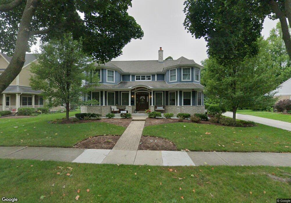
403 Ames St Libertyville, IL 60048
South Libertyville NeighborhoodEstimated Value: $555,000 - $1,453,478
3
Beds
2
Baths
1,564
Sq Ft
$729/Sq Ft
Est. Value
About This Home
This home is located at 403 Ames St, Libertyville, IL 60048 and is currently estimated at $1,140,159, approximately $729 per square foot. 403 Ames St is a home located in Lake County with nearby schools including Rockland Elementary School, Highland Middle School, and Libertyville High School.
Ownership History
Date
Name
Owned For
Owner Type
Purchase Details
Closed on
Jun 21, 2012
Sold by
Greenhill Johnson Tammy
Bought by
Antognoli Michael and Antognoli Lara
Current Estimated Value
Purchase Details
Closed on
Feb 15, 2012
Sold by
Piasecki Nancy A and Olive A Cooper Declaration Of
Bought by
Greenhill Johnson Tammy
Purchase Details
Closed on
Feb 10, 2012
Sold by
Atg Trust Company
Bought by
Greenhill Johnson Tammy
Create a Home Valuation Report for This Property
The Home Valuation Report is an in-depth analysis detailing your home's value as well as a comparison with similar homes in the area
Home Values in the Area
Average Home Value in this Area
Purchase History
| Date | Buyer | Sale Price | Title Company |
|---|---|---|---|
| Antognoli Michael | $300,000 | None Available | |
| Greenhill Johnson Tammy | -- | Greater Metropolitan Title L | |
| Greenhill Johnson Tammy | $225,000 | Greater Metropolitan Title L |
Source: Public Records
Tax History Compared to Growth
Tax History
| Year | Tax Paid | Tax Assessment Tax Assessment Total Assessment is a certain percentage of the fair market value that is determined by local assessors to be the total taxable value of land and additions on the property. | Land | Improvement |
|---|---|---|---|---|
| 2024 | $28,713 | $403,140 | $96,684 | $306,456 |
| 2023 | $26,707 | $371,831 | $89,175 | $282,656 |
| 2022 | $26,707 | $345,157 | $85,712 | $259,445 |
| 2021 | $25,723 | $337,727 | $83,867 | $253,860 |
| 2020 | $24,764 | $332,049 | $82,457 | $249,592 |
| 2019 | $24,147 | $323,912 | $81,673 | $242,239 |
| 2018 | $24,097 | $333,945 | $83,704 | $250,241 |
| 2017 | $23,769 | $323,402 | $81,061 | $242,341 |
| 2016 | $23,007 | $306,629 | $76,857 | $229,772 |
| 2015 | $22,833 | $286,596 | $71,836 | $214,760 |
| 2014 | $10,076 | $264,252 | $66,235 | $198,017 |
| 2012 | $6,935 | $122,388 | $61,862 | $60,526 |
Source: Public Records
Map
Nearby Homes
- 423 Ames St
- 0 Ames St
- 551 W Park Ave Unit E
- 308 Mckinley Ave
- 533 Drake St
- 1754 Glenmore Rd
- 212 Elm Ct
- 747 Garfield Ave Unit C
- 426 S Milwaukee Ave
- 777 Garfield Ave Unit A
- 420 W Cook Ave
- 505 Lange Ct
- 1137 Pine Tree Ln
- 851 Garfield Ave Unit C
- 323 W Golf Rd
- 217 E Church St
- 1330 W Park Ave
- 223 Kenloch Ave
- 1017 Juniper Pkwy
- 401 S 4th Ave