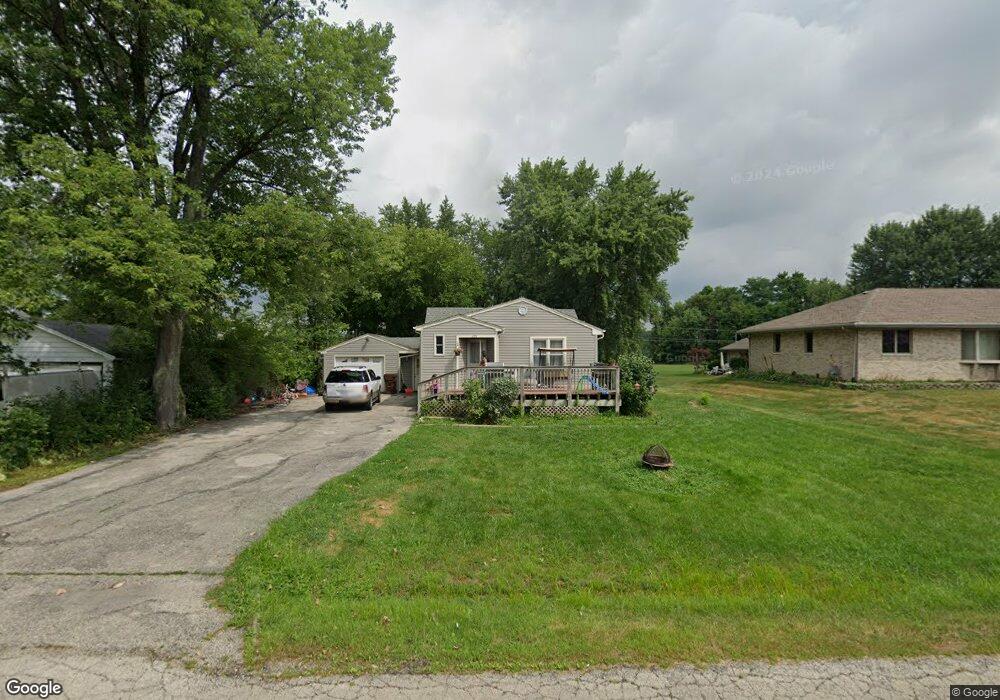
403 Connor Ave Lockport, IL 60441
South Lockport NeighborhoodEstimated Value: $188,052 - $313,000
--
Bed
--
Bath
--
Sq Ft
7,841
Sq Ft Lot
About This Home
This home is located at 403 Connor Ave, Lockport, IL 60441 and is currently estimated at $257,513. 403 Connor Ave is a home located in Will County with nearby schools including Fairmont School, Lockport Township High School East, and Saint Dennis School.
Ownership History
Date
Name
Owned For
Owner Type
Purchase Details
Closed on
Dec 13, 2002
Sold by
Johnson Paul
Bought by
Klausegger Eric
Current Estimated Value
Home Financials for this Owner
Home Financials are based on the most recent Mortgage that was taken out on this home.
Original Mortgage
$52,000
Outstanding Balance
$22,320
Interest Rate
6.23%
Estimated Equity
$235,193
Purchase Details
Closed on
Dec 15, 1995
Sold by
Va
Bought by
Johnson Paul
Home Financials for this Owner
Home Financials are based on the most recent Mortgage that was taken out on this home.
Original Mortgage
$53,000
Interest Rate
7.28%
Create a Home Valuation Report for This Property
The Home Valuation Report is an in-depth analysis detailing your home's value as well as a comparison with similar homes in the area
Home Values in the Area
Average Home Value in this Area
Purchase History
| Date | Buyer | Sale Price | Title Company |
|---|---|---|---|
| Klausegger Eric | $65,000 | -- | |
| Johnson Paul | -- | Premier Title Company |
Source: Public Records
Mortgage History
| Date | Status | Borrower | Loan Amount |
|---|---|---|---|
| Open | Klausegger Eric | $52,000 | |
| Previous Owner | Johnson Paul | $53,000 |
Source: Public Records
Tax History Compared to Growth
Tax History
| Year | Tax Paid | Tax Assessment Tax Assessment Total Assessment is a certain percentage of the fair market value that is determined by local assessors to be the total taxable value of land and additions on the property. | Land | Improvement |
|---|---|---|---|---|
| 2024 | $4,474 | $53,109 | $23,097 | $30,012 |
| 2023 | $4,474 | $47,678 | $20,735 | $26,943 |
| 2022 | $3,756 | $41,494 | $18,045 | $23,449 |
| 2021 | $3,642 | $38,994 | $16,958 | $22,036 |
| 2020 | $3,572 | $37,711 | $16,400 | $21,311 |
| 2019 | $3,448 | $35,745 | $15,545 | $20,200 |
| 2018 | $3,170 | $32,445 | $14,110 | $18,335 |
| 2017 | $2,966 | $29,451 | $12,808 | $16,643 |
| 2016 | $2,705 | $26,139 | $11,368 | $14,771 |
| 2015 | $2,485 | $22,817 | $9,923 | $12,894 |
| 2014 | $2,485 | $21,525 | $9,361 | $12,164 |
| 2013 | $2,485 | $23,397 | $10,175 | $13,222 |
Source: Public Records
Map
Nearby Homes
- 302 Hughes Ave
- Lots 57, 58, 59 & 60 Green Garden Place
- 403 North Ave
- 2004 Boehme St
- 222 Nobes Ave
- 2021 Princess Ct
- 2009 Princess Ct
- 2005 Princess Ct
- 308 Dellwood Ave
- 101 Dellwood Ave
- 216 Dellwood Ave
- 17045 Sterling Dr
- 516 Whelan St
- 1914 S Austrian Pine St Unit 2
- 217 Riley Ave
- 1623 East St
- 219 Reverend Walton Dr
- 2141 California Ave
- 2215 Fairview Ave
- 122 Barry Ave
- 223 Lois Ave Unit 1
- 405 Connor Ave
- 221 Lois Ave
- 301 Lois Ave
- 407 Connor Ave
- 337 Connor Ave
- 404 Connor Ave Unit 1
- 303 Lois Ave
- 336 Hughes Ave
- 335 Connor Ave
- 406 Connor Ave
- 334 Connor Ave
- 334 Hughes Ave
- 408 Connor Ave
- 329 Connor Ave
- 411 Connor Ave
- 330 Connor Ave
- 341 Cameron Ave
- 330 Hughes Ave
- 333 Hughes Ave