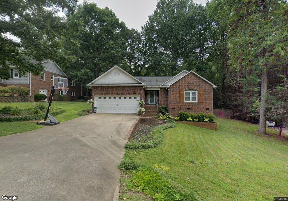
403 Pinehurst Dr Kings Mountain, NC 28086
Estimated Value: $315,000 - $325,000
3
Beds
2
Baths
1,728
Sq Ft
$185/Sq Ft
Est. Value
About This Home
This home is located at 403 Pinehurst Dr, Kings Mountain, NC 28086 and is currently estimated at $319,745, approximately $185 per square foot. 403 Pinehurst Dr is a home located in Cleveland County with nearby schools including West Elementary School, Kings Mountain Middle, and Kings Mountain Intermediate School.
Ownership History
Date
Name
Owned For
Owner Type
Purchase Details
Closed on
Jun 20, 2014
Sold by
Hardin Clint M and Hardin Brooke Lee
Bought by
Pressley Ashley N
Current Estimated Value
Purchase Details
Closed on
Oct 23, 2008
Sold by
Hull David and Clavier Monique Michele
Bought by
Lee Brooke O and Hardin Clint M
Home Financials for this Owner
Home Financials are based on the most recent Mortgage that was taken out on this home.
Original Mortgage
$121,050
Interest Rate
3.75%
Mortgage Type
Purchase Money Mortgage
Create a Home Valuation Report for This Property
The Home Valuation Report is an in-depth analysis detailing your home's value as well as a comparison with similar homes in the area
Home Values in the Area
Average Home Value in this Area
Purchase History
| Date | Buyer | Sale Price | Title Company |
|---|---|---|---|
| Pressley Ashley N | $156,000 | None Available | |
| Lee Brooke O | $134,500 | None Available |
Source: Public Records
Mortgage History
| Date | Status | Borrower | Loan Amount |
|---|---|---|---|
| Previous Owner | Lee Brooke O | $121,050 |
Source: Public Records
Tax History Compared to Growth
Tax History
| Year | Tax Paid | Tax Assessment Tax Assessment Total Assessment is a certain percentage of the fair market value that is determined by local assessors to be the total taxable value of land and additions on the property. | Land | Improvement |
|---|---|---|---|---|
| 2025 | $2,922 | $285,095 | $20,000 | $265,095 |
| 2024 | $2,235 | $189,268 | $16,500 | $172,768 |
| 2023 | $2,140 | $189,268 | $16,500 | $172,768 |
| 2022 | $2,129 | $189,268 | $16,500 | $172,768 |
| 2021 | $2,140 | $189,268 | $16,500 | $172,768 |
| 2020 | $1,867 | $160,431 | $16,200 | $144,231 |
| 2019 | $1,867 | $160,431 | $16,200 | $144,231 |
| 2018 | $1,866 | $160,431 | $16,200 | $144,231 |
| 2017 | $1,856 | $160,431 | $16,200 | $144,231 |
| 2016 | $1,864 | $160,431 | $16,200 | $144,231 |
| 2015 | $1,671 | $147,554 | $13,500 | $134,054 |
| 2014 | $1,671 | $147,554 | $13,500 | $134,054 |
Source: Public Records
Map
Nearby Homes
- 0 Southridge Dr Unit CAR4298120
- 804 Lee St
- 230 Paige Rd
- 245 Paige Rd
- 218 Paige Rd
- 212 Paige Rd
- 149 Parker Claire Ln
- 227 Paige Rd
- 123 Parker Claire Ln
- 219 Parker Claire Ln
- 143 Parker Claire Ln
- 137 Parker Claire Ln
- 157 Parker Claire Ln
- 104 Parker Claire Ln
- 207 Parker Claire Ln
- Belhaven Plan at Brinkley Ridge
- Freeport Plan at Brinkley Ridge
- Robie Plan at Brinkley Ridge
- Penwell Plan at Brinkley Ridge
- Aria Plan at Brinkley Ridge
- 323 Pinehurst Dr
- 405 Pinehurst Dr
- 321 Pinehurst Dr
- 820 Southridge Dr
- 819 Southridge Dr
- 817 Southridge Dr
- 0 Southridge Dr Unit 3124291
- 0 Southridge Dr Unit CAR4191254
- 317 Pinehurst Dr
- 800 Kingswood Ct
- 815 Southridge Dr
- 812 Southridge Dr
- 313 Pinehurst Dr
- 804 Kingswood Ct
- 902 Lee St
- 809 Kingswood Ct
- 809 Kingswood Ct Unit 37 & 38
- 317 Amhurst Dr
- 805 Kingswood Ct
- 315 Amhurst Dr