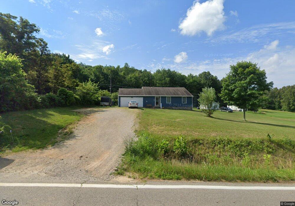
4032 State Route 772 Chillicothe, OH 45601
Estimated Value: $172,000 - $213,000
3
Beds
1
Bath
1,080
Sq Ft
$180/Sq Ft
Est. Value
About This Home
This home is located at 4032 State Route 772, Chillicothe, OH 45601 and is currently estimated at $194,311, approximately $179 per square foot. 4032 State Route 772 is a home located in Ross County with nearby schools including Huntington Elementary School, Huntington Middle School, and Huntington High School.
Ownership History
Date
Name
Owned For
Owner Type
Purchase Details
Closed on
Jul 20, 2006
Sold by
Hart Melvin and Hart Rita
Bought by
Walsh Dennis M and Walsh Angela M
Current Estimated Value
Home Financials for this Owner
Home Financials are based on the most recent Mortgage that was taken out on this home.
Original Mortgage
$90,000
Outstanding Balance
$53,666
Interest Rate
6.73%
Mortgage Type
Stand Alone First
Estimated Equity
$140,645
Purchase Details
Closed on
Dec 12, 2005
Sold by
Jackson Alphonso R
Bought by
Hart Melvin and Hart Rita
Create a Home Valuation Report for This Property
The Home Valuation Report is an in-depth analysis detailing your home's value as well as a comparison with similar homes in the area
Home Values in the Area
Average Home Value in this Area
Purchase History
| Date | Buyer | Sale Price | Title Company |
|---|---|---|---|
| Walsh Dennis M | $90,000 | Title First | |
| Hart Melvin | -- | Lakeside Title & Escrow |
Source: Public Records
Mortgage History
| Date | Status | Borrower | Loan Amount |
|---|---|---|---|
| Open | Walsh Dennis M | $90,000 |
Source: Public Records
Tax History Compared to Growth
Tax History
| Year | Tax Paid | Tax Assessment Tax Assessment Total Assessment is a certain percentage of the fair market value that is determined by local assessors to be the total taxable value of land and additions on the property. | Land | Improvement |
|---|---|---|---|---|
| 2024 | $1,641 | $45,590 | $4,770 | $40,820 |
| 2023 | $1,641 | $45,590 | $4,770 | $40,820 |
| 2022 | $1,656 | $45,590 | $4,770 | $40,820 |
| 2021 | $1,297 | $33,780 | $3,380 | $30,400 |
| 2020 | $1,295 | $33,780 | $3,380 | $30,400 |
| 2019 | $1,326 | $33,780 | $3,380 | $30,400 |
| 2018 | $1,145 | $28,450 | $3,270 | $25,180 |
| 2017 | $1,150 | $28,450 | $3,270 | $25,180 |
| 2016 | $1,123 | $28,450 | $3,270 | $25,180 |
| 2015 | $1,172 | $30,020 | $3,270 | $26,750 |
| 2014 | $1,099 | $30,020 | $3,270 | $26,750 |
| 2013 | $1,105 | $30,020 | $3,270 | $26,750 |
Source: Public Records
Map
Nearby Homes
- 157 Easterday Rd
- 767 Valley Rd
- 0 Windy Ridge Rd
- 5690 Blain Hwy
- 3272 Black Run Rd
- 1429 Mount Tabor Rd
- 3101 Mount Tabor Rd
- 850 Nipgen Rd
- 5171 Denver Rd
- 1048 Beatty Rd
- 8583 Ohio 772
- 0 Beatty Rd
- 4056 Clines Chapel Rd
- 4878 Black Run Rd
- 0 Spargursville Rd Unit WAVERLY OH 45690
- 935 Keiser Rd
- 0 Carl Penn Rd
- 1886 Blain Hwy
- 0 Pennington Rd Unit 198207
- 769 Markham Rd
- 4100 State Route 772
- 3930 State Route 772
- 3873 State Route 772
- 3873 Ohio 772
- 3839 Ohio 772
- 3721 State Route 772
- 4249 State Route 772
- 4249 Ohio 772
- 411 Black Run Rd
- 4309 State Route 772
- 4311 State Route 772
- 3690 Ohio 772
- 8869 Denver Rd
- 4385 Ohio 772
- 355 Black Run Rd
- 475 Black Run Rd
- 285 Black Run Rd
- 3687 State Route 772
- 4425 State Route 772
- 221 Black Run Rd