Estimated Value: $594,000 - $627,000
4
Beds
3
Baths
3,105
Sq Ft
$196/Sq Ft
Est. Value
About This Home
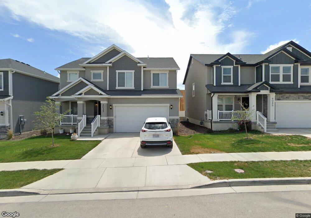
This home is located at 4033 W 1700 N, Lehi, UT 84043 and is currently estimated at $609,641, approximately $196 per square foot. 4033 W 1700 N is a home located in Utah County with nearby schools including North Point Elementary School, Willowcreek Middle School, and Lehi High School.
Ownership History
Date
Name
Owned For
Owner Type
Purchase Details
Closed on
May 28, 2020
Sold by
Stevens Kent and Stevens Barbara
Bought by
Woodard Brandon and Woodard Shelby
Current Estimated Value
Home Financials for this Owner
Home Financials are based on the most recent Mortgage that was taken out on this home.
Original Mortgage
$337,450
Outstanding Balance
$299,681
Interest Rate
3.3%
Mortgage Type
New Conventional
Estimated Equity
$309,960
Purchase Details
Closed on
Sep 4, 2018
Sold by
Edge Homes Utah Llc
Bought by
Stevens Kent and Stevens Barbara
Home Financials for this Owner
Home Financials are based on the most recent Mortgage that was taken out on this home.
Original Mortgage
$279,728
Interest Rate
4.5%
Mortgage Type
New Conventional
Create a Home Valuation Report for This Property
The Home Valuation Report is an in-depth analysis detailing your home's value as well as a comparison with similar homes in the area
Home Values in the Area
Average Home Value in this Area
Purchase History
| Date | Buyer | Sale Price | Title Company |
|---|---|---|---|
| Woodard Brandon | -- | Real Advantage Ttl Ins Gency | |
| Stevens Kent | -- | Provo Land Title Co |
Source: Public Records
Mortgage History
| Date | Status | Borrower | Loan Amount |
|---|---|---|---|
| Open | Woodard Brandon | $337,450 | |
| Previous Owner | Stevens Kent | $279,728 |
Source: Public Records
Tax History Compared to Growth
Tax History
| Year | Tax Paid | Tax Assessment Tax Assessment Total Assessment is a certain percentage of the fair market value that is determined by local assessors to be the total taxable value of land and additions on the property. | Land | Improvement |
|---|---|---|---|---|
| 2025 | $2,507 | $319,990 | $226,800 | $355,000 |
| 2024 | $2,507 | $293,810 | $0 | $0 |
| 2023 | $2,341 | $297,880 | $0 | $0 |
| 2022 | $2,479 | $305,855 | $0 | $0 |
| 2021 | $2,058 | $383,800 | $135,400 | $248,400 |
| 2020 | $1,951 | $359,700 | $120,900 | $238,800 |
| 2019 | $1,816 | $348,100 | $126,800 | $221,300 |
Source: Public Records
Map
Nearby Homes
- 4037 W 1730 N
- 4089 W 1700 N Unit 618
- 4028 W 1730 N
- 3972 W 1530 N
- 4057 W 1760 N
- 1629 N 3860 W
- 1632 N 3830 W
- 4126 W 1530 N Unit DD101
- 2773 N Tower Way
- 236 W Glenbrittle Dr Unit 204
- 1606 N 4230 W
- 4827 N Sage Dr
- 3984 W 1850 N Unit D102
- 1731 N 3780 W
- 4173 W 1850 N
- 1453 N 3860 W Unit 108
- 1630 N 3740 W Unit 1955
- 1624 N 3740 W
- 3852 W 1850 N Unit 204
- 3985 W 1960 N
- 4033 W 1700 N Unit 622
- 4025 W 1700 N Unit 623
- 4045 W 1700 N Unit 621
- 4050 W 1650 N
- 4050 W 1650 N Unit 2141
- 4044 W 1650 N Unit 2140
- 4056 W 1650 N Unit 2142
- 4038 W 1650 N Unit 2139
- 4017 W 1700 N Unit 624
- 4017 W 1700 N
- 4059 W 1700 N Unit 620
- 4066 W 1650 N Unit 784
- 4066 W 1650 N
- 4028 W 1650 N Unit 2138
- 4072 W 1650 N Unit 785
- 4022 W 1650 N Unit 2137
- 4036 W 1700 N Unit 613
- 4028 W 1700 N Unit 612
- 4009 W 1700 N Unit 625
- 4071 W 1700 N Unit 619