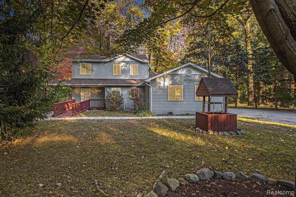
404 N Sybald St Westland, MI 48185
Estimated payment $2,226/month
Highlights
- 1.35 Acre Lot
- Fireplace in Primary Bedroom
- Ground Level Unit
- Colonial Architecture
- Deck
- No HOA
About This Home
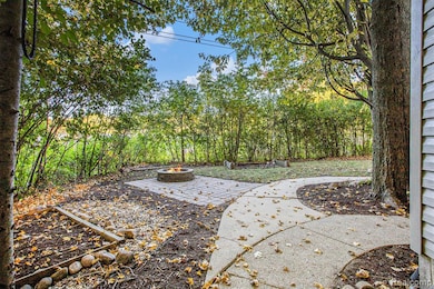
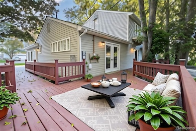
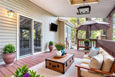
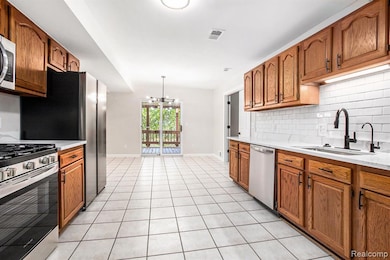
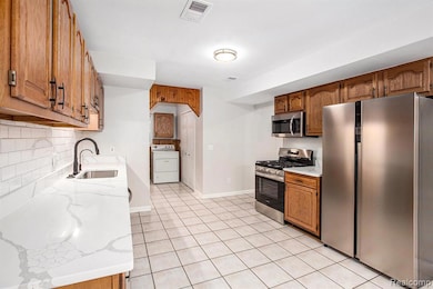
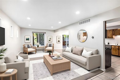
BACK ON MARKET - OPEN HOUSES SAT 1-3 AND SUN 11-1. Your peaceful retreat in the heart of convenience. Nestled on 1.35 wooded acres in a quiet neighborhood just across from Canton, this beautifully remodeled two-story colonial blends the charm of country living with the ease of city access. Step inside to over 2,200 square feet of modern comfort and timeless character. The main level offers a thoughtful, open flow featuring a first-floor primary suite with a walk-in closet, gas fireplace, and a fully renovated ensuite bath — the perfect place to unwind. The living room creates an inviting space for gatherings and relaxation. A formal dining area connects seamlessly to the updated kitchen, showcasing quartz countertops, stainless steel appliances, a new sink and fixtures, and freshly refinished cabinetry. Upstairs, you’ll find three generous bedrooms and a full bath, providing plenty of space for family, guests, or a home office setup. Enjoy morning coffee or evening dinners on the covered deck with skylights, overlooking your private, tree-lined backyard. The property also includes a covered front porch, shed, and a 528-sq-ft detached garage with a covered walkway for year-round convenience.
Full 2025 renovation: new carpet, paint, light fixtures, recessed lighting, bathrooms, kitchen, and landscaping
Newer furnace, newer hot water tank, and central air conditioning for peace of mind. Wheelchair accessible.
Tucked away in a peaceful, mature-tree neighborhood, this home offers that sought-after “up north feel” while being moments from everything you need. You’re just minutes to Canton’s Ford Road corridor, featuring many restaurants plus shopping destinations such as IKEA, Target, and Kroger Marketplace. Easy access to I-275, Michigan Ave, and Haggerty Rd keeps Ann Arbor, Novi, and Metro Detroit within easy reach.
Enjoy nearby recreation at Heritage Park, Holliday Nature Preserve, and Golf Club of Canton — all within minutes of your front door.
Home Details
Home Type
- Single Family
Est. Annual Taxes
Year Built
- Built in 1994 | Remodeled in 2025
Lot Details
- 1.35 Acre Lot
- Lot Dimensions are 288x78.95
- Dirt Road
- Irregular Lot
Home Design
- Colonial Architecture
- Slab Foundation
- Vinyl Construction Material
Interior Spaces
- 2,261 Sq Ft Home
- 2-Story Property
- Ceiling Fan
- Recessed Lighting
- Gas Fireplace
Kitchen
- Free-Standing Gas Oven
- Free-Standing Gas Range
- Microwave
- Dishwasher
- Stainless Steel Appliances
Bedrooms and Bathrooms
- 4 Bedrooms
- Fireplace in Primary Bedroom
- 2 Full Bathrooms
Laundry
- Dryer
- Washer
Parking
- 2 Car Detached Garage
- Driveway
Accessible Home Design
- Accessible Full Bathroom
- Accessible Bedroom
- Accessible Common Area
- Accessible Kitchen
- Kitchen Appliances
- Central Living Area
- Accessible Hallway
- Accessible Closets
- Accessible Washer and Dryer
- Accessible Doors
- Accessible Approach with Ramp
- Accessible Entrance
Outdoor Features
- Deck
- Covered Patio or Porch
- Shed
- Breezeway
- Rain Gutter Guard System
Location
- Ground Level Unit
Utilities
- Forced Air Heating and Cooling System
- Heating System Uses Natural Gas
- Programmable Thermostat
Community Details
- No Home Owners Association
- Cherry Hill Grove Sub Subdivision
Listing and Financial Details
- Assessor Parcel Number 56052010194327
Map
Home Values in the Area
Average Home Value in this Area
Tax History
| Year | Tax Paid | Tax Assessment Tax Assessment Total Assessment is a certain percentage of the fair market value that is determined by local assessors to be the total taxable value of land and additions on the property. | Land | Improvement |
|---|---|---|---|---|
| 2025 | $3,811 | $216,100 | $0 | $0 |
| 2024 | $3,811 | $189,100 | $0 | $0 |
| 2023 | $3,639 | $147,000 | $0 | $0 |
| 2022 | $4,143 | $130,500 | $0 | $0 |
| 2021 | $4,040 | $125,800 | $0 | $0 |
| 2020 | $3,997 | $119,700 | $0 | $0 |
| 2019 | $3,851 | $104,800 | $0 | $0 |
| 2018 | $2,994 | $90,200 | $0 | $0 |
| 2017 | $1,248 | $127,900 | $0 | $0 |
| 2016 | $5,084 | $125,600 | $0 | $0 |
| 2015 | $9,028 | $106,460 | $0 | $0 |
| 2013 | $8,812 | $90,810 | $0 | $0 |
| 2012 | $4,108 | $88,930 | $0 | $0 |
Property History
| Date | Event | Price | List to Sale | Price per Sq Ft |
|---|---|---|---|---|
| 10/18/2025 10/18/25 | For Sale | $350,000 | -- | $155 / Sq Ft |
Purchase History
| Date | Type | Sale Price | Title Company |
|---|---|---|---|
| Warranty Deed | $225,000 | Vital Title | |
| Quit Claim Deed | $45,000 | None Available | |
| Interfamily Deed Transfer | -- | None Available | |
| Deed | $65,000 | None Available | |
| Warranty Deed | -- | None Available | |
| Sheriffs Deed | $217,533 | None Available | |
| Warranty Deed | $190,000 | Multiple |
Mortgage History
| Date | Status | Loan Amount | Loan Type |
|---|---|---|---|
| Open | $242,500 | Credit Line Revolving |
Source: Realcomp
MLS Number: 20251046067
APN: 56-052-01-0194-327
Disclaimer: Certain information contained herein is derived from information provided by parties other than Homes.com. All information provided is deemed reliable, but is not guaranteed to be accurate and should be independently verified.
![]() IDX provided courtesy of Realcomp II Ltd. via Ten-X and MLS
IDX provided courtesy of Realcomp II Ltd. via Ten-X and MLS
Copyright 2025 Realcomp II Ltd. Shareholders
IDX information is provided exclusively for consumers' personal, noncommercial use and may not be used for any purpose other than to identify prospective properties consumers may be interested in purchasing. The accuracy of all information, regardless of source, is not guaranteed or warranted. All information should be independently verified.
Listing Information presented by local MLS brokerage: Ten-X, local REALTOR®- Arlene Richardson - (888)-952-6393
- 457 N Sybald St
- 127 S John Hix St
- 37176 Condor Ct Unit 31
- 571 Summerfield Dr Unit 196
- 714 Autumn Ridge Dr Unit 64
- 38122 Hixford Place
- 38074 Hixford Place
- 285 Carson Dr Unit 156
- 511 S Bryar St
- 1750 N Hix Rd
- 285 Brookfield Dr Unit 25
- 38030 Greenwood St
- 38066 Sherwood St
- 38141 Sherwood St Unit 103
- 38291 Warner Farms Dr Unit 10
- 38302 Warner Farms Dr Unit 24
- 39214 Dillingham St
- 39279 Huron Pkwy
- 38343 Carolon Blvd
- 38290 Avondale St
- 382 Marigold Cir Unit 75
- 313 Marigold Cir Unit 26
- 328 Marigold Cir Unit 94
- 370 Hickory Ln
- 38030 Greenwood St
- 1673 Fairwood Dr
- 147 S Carlson St
- 555 Worthington Rd
- 1824 N Crown St Unit 1824
- 201 Cassia Ct
- 40645 Douglas Dr
- 5955 Edinburgh St
- 40433 Bluesprings Ct Unit 1
- 1947 Cottrill Ln
- 41376 Williamsburg Blvd
- 5868 N Linville St
- 5865 N Parent St
- 37140 Orchard Cir
- 41350 Southwind Dr
- 41265 Crossbow Cir
