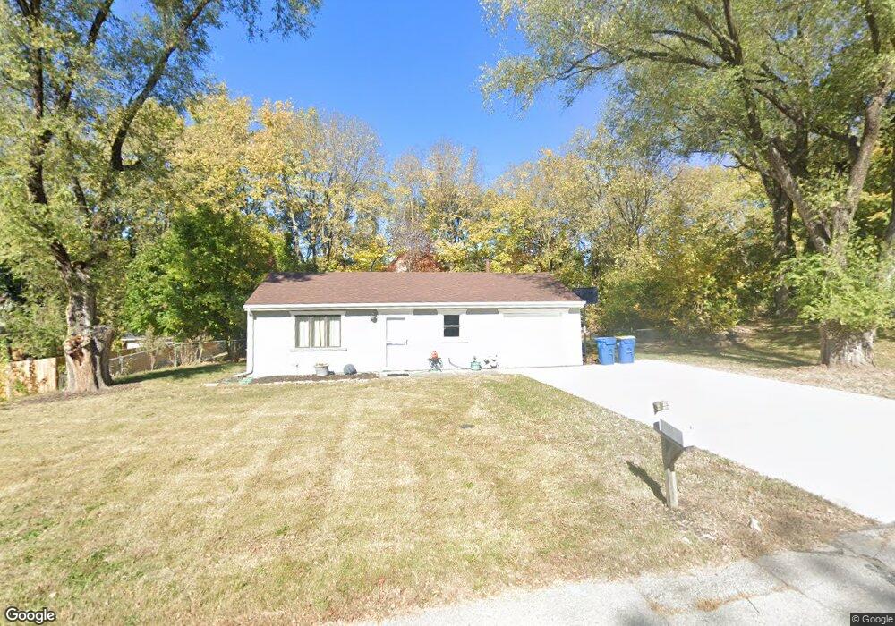
404 Wherritt Ln Liberty, MO 64068
Estimated Value: $162,000 - $195,000
2
Beds
1
Bath
638
Sq Ft
$281/Sq Ft
Est. Value
About This Home
This home is located at 404 Wherritt Ln, Liberty, MO 64068 and is currently estimated at $179,035, approximately $280 per square foot. 404 Wherritt Ln is a home located in Clay County with nearby schools including Alexander Doniphan Elementary School, Discovery Middle School, and Liberty High School.
Ownership History
Date
Name
Owned For
Owner Type
Purchase Details
Closed on
May 8, 2021
Sold by
Beckham Jeff and Beckham Lisa
Bought by
Petty Frances M
Current Estimated Value
Home Financials for this Owner
Home Financials are based on the most recent Mortgage that was taken out on this home.
Original Mortgage
$106,000
Outstanding Balance
$96,062
Interest Rate
3.1%
Mortgage Type
New Conventional
Estimated Equity
$82,973
Purchase Details
Closed on
Oct 19, 2020
Sold by
Lawson Jason Mark and Lawson Misty
Bought by
Beckham Jeff
Purchase Details
Closed on
Oct 27, 2007
Sold by
Citibank Na
Bought by
Lawson Jason Mark
Home Financials for this Owner
Home Financials are based on the most recent Mortgage that was taken out on this home.
Original Mortgage
$55,000
Interest Rate
6.42%
Mortgage Type
Purchase Money Mortgage
Purchase Details
Closed on
Aug 23, 2007
Sold by
Mcadams David C and Mcadams Dianna D
Bought by
Citibank Na
Create a Home Valuation Report for This Property
The Home Valuation Report is an in-depth analysis detailing your home's value as well as a comparison with similar homes in the area
Home Values in the Area
Average Home Value in this Area
Purchase History
| Date | Buyer | Sale Price | Title Company |
|---|---|---|---|
| Petty Frances M | -- | None Available | |
| Beckham Jeff | -- | None Available | |
| Lawson Jason Mark | -- | Continental Title Company | |
| Citibank Na | $56,601 | None Available |
Source: Public Records
Mortgage History
| Date | Status | Borrower | Loan Amount |
|---|---|---|---|
| Open | Petty Frances M | $106,000 | |
| Previous Owner | Lawson Jason Mark | $55,000 |
Source: Public Records
Tax History Compared to Growth
Tax History
| Year | Tax Paid | Tax Assessment Tax Assessment Total Assessment is a certain percentage of the fair market value that is determined by local assessors to be the total taxable value of land and additions on the property. | Land | Improvement |
|---|---|---|---|---|
| 2025 | $1,104 | $16,990 | -- | -- |
| 2024 | $1,104 | $14,950 | -- | -- |
| 2023 | $1,120 | $14,950 | $0 | $0 |
| 2022 | $1,035 | $13,660 | $0 | $0 |
| 2021 | $1,039 | $13,661 | $6,004 | $7,657 |
| 2020 | $1,080 | $13,400 | $0 | $0 |
| 2019 | $1,081 | $13,395 | $6,650 | $6,745 |
| 2018 | $815 | $9,920 | $0 | $0 |
| 2017 | $806 | $9,920 | $3,420 | $6,500 |
| 2016 | $806 | $9,920 | $3,420 | $6,500 |
| 2015 | $806 | $9,920 | $3,420 | $6,500 |
| 2014 | $808 | $9,920 | $3,420 | $6,500 |
Source: Public Records
Map
Nearby Homes
- 1537 Canterbury Ln
- 1733 Welleslay Ln
- 1507 Amesbury Ave
- 1327 Easton Ct
- 1323 Amesbury Ave
- 1205 Blackberry Dr
- 1304 Wellington Way
- 1218 Canterbury Ln
- 1856 Arbor Trail
- 1836 Green Meadow Dr
- 2188 Heritage Ct
- McKinley Plan at Homestead of Liberty - Homestead
- Monroe Plan at Homestead of Liberty - Homestead
- Chestnut Plan at Homestead of Liberty - Homestead
- The Brooklyn Plan at Homestead of Liberty - Homestead
- Cypress Plan at Homestead of Liberty - Homestead
- The Linden Plan at Homestead of Liberty - Homestead
- Spruce Plan at Homestead of Liberty - Homestead
- Ashton Plan at Homestead of Liberty - Homestead
- Meg Plan at Homestead of Liberty - Homestead
- 406 Wherritt Ln
- 402 Wherritt Ln
- 1608 Canterbury Ct
- 1609 Canterbury Ct
- 405 Wherritt Ln
- 403 Wherritt Ln
- 407 Wherritt Ln
- 401 Wherritt Ln
- 1604 Canterbury Ct
- 1605 Canterbury Ct
- 97 Kirkland Ave
- 1604 Chauncey Ct
- 1578 Merit Ln
- 1608 Chauncey Ct
- 1705 S Wales
- 1600 Canterbury Ct
- 1601 Canterbury Ct
- 103 Kirkland Ave
- 1709 S Wales
- 1574 Merit Ln