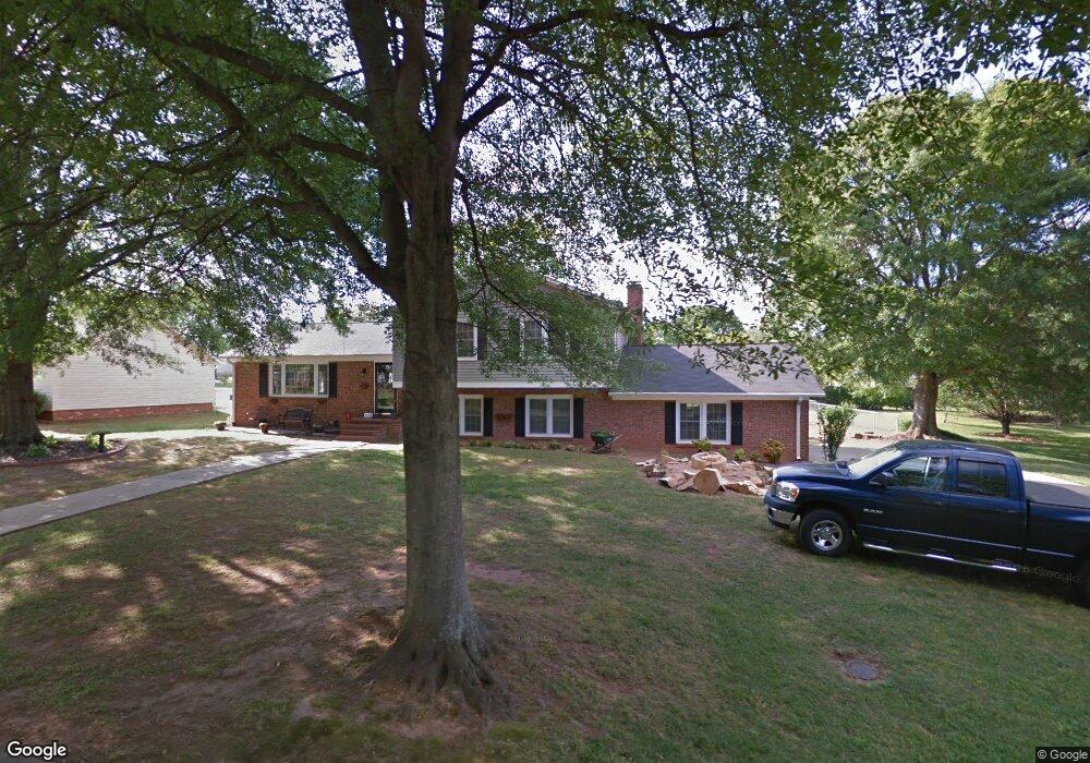
405 Andulusian Trail Simpsonville, SC 29681
Estimated Value: $341,000 - $382,000
3
Beds
2
Baths
2,183
Sq Ft
$164/Sq Ft
Est. Value
About This Home
This home is located at 405 Andulusian Trail, Simpsonville, SC 29681 and is currently estimated at $358,797, approximately $164 per square foot. 405 Andulusian Trail is a home located in Greenville County with nearby schools including Mauldin Elementary School, Mauldin Middle School, and Mauldin High School.
Ownership History
Date
Name
Owned For
Owner Type
Purchase Details
Closed on
Dec 30, 2022
Sold by
Surett Johnny Everett
Bought by
Jones Surrett Joycec
Current Estimated Value
Purchase Details
Closed on
Jan 12, 2017
Sold by
Surrett Joyce J
Bought by
Surrett Joyce J and Surrett Johnny Everette
Purchase Details
Closed on
Aug 20, 2004
Sold by
Glowacki Mark F
Bought by
Surrett Joyce J
Purchase Details
Closed on
Feb 21, 2002
Sold by
Illing Bradley L
Bought by
Glowacki Mark F
Create a Home Valuation Report for This Property
The Home Valuation Report is an in-depth analysis detailing your home's value as well as a comparison with similar homes in the area
Home Values in the Area
Average Home Value in this Area
Purchase History
| Date | Buyer | Sale Price | Title Company |
|---|---|---|---|
| Jones Surrett Joycec | -- | -- | |
| Surrett Joyce J | -- | None Available | |
| Surrett Joyce J | $147,900 | -- | |
| Glowacki Mark F | $137,550 | -- |
Source: Public Records
Tax History
| Year | Tax Paid | Tax Assessment Tax Assessment Total Assessment is a certain percentage of the fair market value that is determined by local assessors to be the total taxable value of land and additions on the property. | Land | Improvement |
|---|---|---|---|---|
| 2025 | $1,116 | $8,050 | $1,740 | $6,310 |
| 2024 | $1,116 | $7,000 | $1,120 | $5,880 |
| 2023 | $1,069 | $7,000 | $1,120 | $5,880 |
| 2022 | $744 | $7,000 | $1,120 | $5,880 |
| 2021 | $744 | $7,000 | $1,120 | $5,880 |
| 2020 | $657 | $6,090 | $970 | $5,120 |
| 2019 | $634 | $6,090 | $970 | $5,120 |
| 2018 | $701 | $6,090 | $970 | $5,120 |
| 2017 | $1,005 | $6,090 | $970 | $5,120 |
| 2016 | $956 | $152,280 | $24,360 | $127,920 |
| 2015 | $957 | $152,280 | $24,360 | $127,920 |
| 2014 | $839 | $132,440 | $24,529 | $107,911 |
Source: Public Records
Map
Nearby Homes
- 1011 Harness Trail
- 139 Forest Lake Dr
- 99 Forest Lake Dr
- 11 Forest Lake Dr
- 21 Kershaw Ct
- 23 Kershaw Ct
- 101 Bell Rd
- 14 Surrywood Dr
- 200 Polo Dr
- 208 Branchester Ct
- 2 Wheat Cressing Ct
- 107 Westcreek Way
- 232 Hardwood Rd
- 10 Hanging Moss Ln
- 19 Rain Flower Dr
- 108 Mineral Ct
- 216 Asheton Lakes Way
- 403 Mossy Ledge Ln
- 32 English Oak Rd
- 103 Oak Meadow Dr
- 403 Andulusian Trail
- 407 Andulusian Trail
- 403 Black Horse Run
- 401 Andulusian Trail
- 108 Hackamore Ct
- 110 Hackamore Ct
- 404 Andulusian Trail
- 402 Andulusian Trail
- 405 Black Horse Run
- 305 Black Horse Run
- 1026 Harness Trail
- 106 Hackamore Ct
- 1027 Harness Trail
- 407 Black Horse Run
- 308 Andulusian Trail
- 104 Percheron Path
- 307 Andulusian Trail
- 404 Black Horse Run
- 112 Hackamore Ct
- 1025 Harness Trail
Your Personal Tour Guide
Ask me questions while you tour the home.