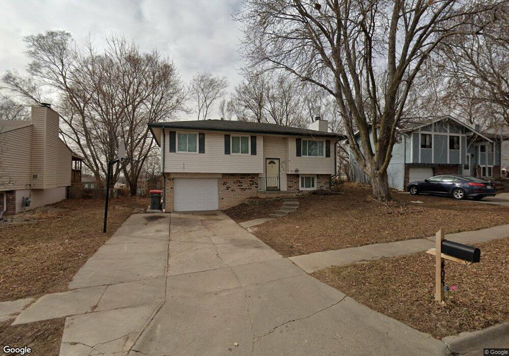
405 Bridger Rd Lincoln, NE 68521
Northwest Lincoln NeighborhoodEstimated Value: $227,076 - $236,000
3
Beds
2
Baths
1,288
Sq Ft
$180/Sq Ft
Est. Value
About This Home
This home is located at 405 Bridger Rd, Lincoln, NE 68521 and is currently estimated at $231,769, approximately $179 per square foot. 405 Bridger Rd is a home located in Lancaster County with nearby schools including West Lincoln Elementary School, Goodrich Middle School, and North Star High School.
Ownership History
Date
Name
Owned For
Owner Type
Purchase Details
Closed on
Sep 10, 2012
Sold by
Recontrust Company Na
Bought by
United Equity Llc
Current Estimated Value
Purchase Details
Closed on
Feb 28, 2006
Sold by
Ebrahim Lisa
Bought by
Mai Son
Home Financials for this Owner
Home Financials are based on the most recent Mortgage that was taken out on this home.
Original Mortgage
$83,200
Interest Rate
7.29%
Mortgage Type
Fannie Mae Freddie Mac
Create a Home Valuation Report for This Property
The Home Valuation Report is an in-depth analysis detailing your home's value as well as a comparison with similar homes in the area
Home Values in the Area
Average Home Value in this Area
Purchase History
| Date | Buyer | Sale Price | Title Company |
|---|---|---|---|
| United Equity Llc | -- | None Available | |
| Mai Son | $104,000 | None Available |
Source: Public Records
Mortgage History
| Date | Status | Borrower | Loan Amount |
|---|---|---|---|
| Previous Owner | Mai Son | $83,200 |
Source: Public Records
Tax History Compared to Growth
Tax History
| Year | Tax Paid | Tax Assessment Tax Assessment Total Assessment is a certain percentage of the fair market value that is determined by local assessors to be the total taxable value of land and additions on the property. | Land | Improvement |
|---|---|---|---|---|
| 2025 | $2,806 | $207,200 | $45,000 | $162,200 |
| 2024 | $2,806 | $200,600 | $35,000 | $165,600 |
| 2023 | $3,151 | $188,000 | $35,000 | $153,000 |
| 2022 | $2,936 | $147,300 | $30,000 | $117,300 |
| 2021 | $2,777 | $147,300 | $30,000 | $117,300 |
| 2020 | $2,478 | $129,700 | $30,000 | $99,700 |
| 2019 | $2,479 | $129,700 | $30,000 | $99,700 |
| 2018 | $2,307 | $120,200 | $30,000 | $90,200 |
| 2017 | $2,328 | $120,200 | $30,000 | $90,200 |
| 2016 | $2,200 | $113,000 | $30,000 | $83,000 |
| 2015 | $2,185 | $113,000 | $30,000 | $83,000 |
| 2014 | $1,994 | $102,500 | $30,000 | $72,500 |
| 2013 | -- | $102,500 | $30,000 | $72,500 |
Source: Public Records
Map
Nearby Homes
- 221 Mormon Trail
- 455 Laramie Trail
- 3100 NW 7th St
- 431 W Belmont Ave
- 205 W Treehaven Dr
- 2808 NW 7th St
- 2503 NW 6th St
- 635 W Fairfield St
- 122 W Saunders Ave
- 1715 W Trout Dr
- 730 W Dawes Ave
- 2500 NW 8th St
- 406 Knox St
- 405 Judson St
- 241 W Irving St
- 2330 N Main St
- 239 W Irving St Unit Portfolio
- 225 W Irving St
- 240 W Irving St
- 208 W Irving St
- 409 Bridger Rd
- 401 Bridger Rd
- 415 Bridger Rd
- 404 Bridger Rd
- 408 Bridger Rd
- 400 Bridger Rd
- 419 Bridger Rd
- 323 Bridger Rd
- 412 Bridger Rd
- 330 Bridger Rd
- 416 Bridger Rd
- 423 Bridger Rd
- 317 Bridger Rd
- 320 Bridger Rd
- 401 W Butler Ave
- 405 Laramie Trail
- 409 Laramie Trail
- 401 Laramie Trail
- 415 Laramie Trail
- 420 Bridger Rd