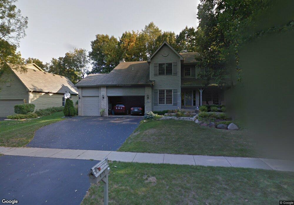
405 Kelly Ln Crystal Lake, IL 60012
Estimated Value: $502,559 - $549,000
4
Beds
3
Baths
2,684
Sq Ft
$197/Sq Ft
Est. Value
About This Home
This home is located at 405 Kelly Ln, Crystal Lake, IL 60012 and is currently estimated at $529,140, approximately $197 per square foot. 405 Kelly Ln is a home located in McHenry County with nearby schools including Prairie Grove Elementary School, Prairie Grove Junior High School, and Prairie Ridge High School.
Ownership History
Date
Name
Owned For
Owner Type
Purchase Details
Closed on
Oct 25, 2024
Sold by
Burnidge Amy and Burnidge Van Der
Bought by
Burnidge Dale
Current Estimated Value
Purchase Details
Closed on
Feb 22, 2024
Sold by
Burnidge Dale
Bought by
Burnidge Dale and Burnidge Amy
Purchase Details
Closed on
Dec 14, 2023
Sold by
Burnidge Amy
Bought by
Burnidge Dale
Purchase Details
Closed on
Jul 31, 2007
Sold by
Reed Margaret A
Bought by
Burnidge Dale and Burnidge Amy
Home Financials for this Owner
Home Financials are based on the most recent Mortgage that was taken out on this home.
Original Mortgage
$380,000
Interest Rate
6.69%
Mortgage Type
Unknown
Purchase Details
Closed on
Dec 18, 2006
Sold by
Reed Terrence L and Reed Margaret A
Bought by
Reed Margaret A and Margaret A Reed Trust
Purchase Details
Closed on
Oct 7, 2004
Sold by
Prudential Residential Service
Bought by
Reed Terrence L and Reed Margaret A
Home Financials for this Owner
Home Financials are based on the most recent Mortgage that was taken out on this home.
Original Mortgage
$316,000
Interest Rate
6.62%
Mortgage Type
Unknown
Purchase Details
Closed on
Sep 10, 2004
Sold by
Jones Richard and Jones Ingrid
Bought by
Prudential Residential Service Lp and Prudential Homes Corp
Home Financials for this Owner
Home Financials are based on the most recent Mortgage that was taken out on this home.
Original Mortgage
$316,000
Interest Rate
6.62%
Mortgage Type
Unknown
Purchase Details
Closed on
Apr 5, 2001
Sold by
Mcgraw R Patrick and Mcgraw Victoria M
Bought by
Jones Richard and Jones Ingrid
Home Financials for this Owner
Home Financials are based on the most recent Mortgage that was taken out on this home.
Original Mortgage
$220,000
Interest Rate
7.05%
Purchase Details
Closed on
Apr 28, 1998
Sold by
Home State Bank National Assn
Bought by
Mcgraw R Patrick and Mcgraw Victoria M
Home Financials for this Owner
Home Financials are based on the most recent Mortgage that was taken out on this home.
Original Mortgage
$235,000
Interest Rate
6.37%
Mortgage Type
Construction
Create a Home Valuation Report for This Property
The Home Valuation Report is an in-depth analysis detailing your home's value as well as a comparison with similar homes in the area
Home Values in the Area
Average Home Value in this Area
Purchase History
| Date | Buyer | Sale Price | Title Company |
|---|---|---|---|
| Burnidge Dale | -- | None Listed On Document | |
| Burnidge Dale | -- | None Listed On Document | |
| Burnidge Dale | -- | None Listed On Document | |
| Burnidge Dale | $413,000 | Republic Title Company | |
| Reed Margaret A | -- | None Available | |
| Reed Terrence L | $395,000 | Ticor | |
| Prudential Residential Service Lp | $395,000 | Ticor | |
| Jones Richard | $303,000 | First American | |
| Mcgraw R Patrick | $275,000 | -- |
Source: Public Records
Mortgage History
| Date | Status | Borrower | Loan Amount |
|---|---|---|---|
| Previous Owner | Burnidge Dale | $380,000 | |
| Previous Owner | Reed Terrence L | $316,000 | |
| Previous Owner | Jones Richard | $220,000 | |
| Previous Owner | Mcgraw R Patrick | $235,000 |
Source: Public Records
Tax History Compared to Growth
Tax History
| Year | Tax Paid | Tax Assessment Tax Assessment Total Assessment is a certain percentage of the fair market value that is determined by local assessors to be the total taxable value of land and additions on the property. | Land | Improvement |
|---|---|---|---|---|
| 2024 | $10,846 | $129,093 | $27,130 | $101,963 |
| 2023 | $10,674 | $115,768 | $24,330 | $91,438 |
| 2022 | $11,176 | $115,529 | $24,009 | $91,520 |
| 2021 | $10,580 | $108,315 | $22,510 | $85,805 |
| 2020 | $10,393 | $105,068 | $21,835 | $83,233 |
| 2019 | $10,161 | $99,894 | $20,760 | $79,134 |
| 2018 | $10,878 | $105,264 | $27,138 | $78,126 |
| 2017 | $10,713 | $100,847 | $25,999 | $74,848 |
| 2016 | $10,562 | $96,219 | $24,806 | $71,413 |
| 2013 | -- | $83,921 | $23,607 | $60,314 |
Source: Public Records
Map
Nearby Homes
- 462 Kelly Ln
- 532 Nunda Trail
- 5804 Terra Cotta Rd
- 654 Cassia Ct
- 648 Cassia Ct
- 660 Cassia Ct
- 546 Cimmaron Cir
- 632 Cassia Ct
- 634 Cassia Ct
- Charlotte Plan at Woodlore Estates - Woodlore Townes - Phase 2
- Marianne Plan at Woodlore Estates - Woodlore Townes - Phase 2
- Darcy Plan at Woodlore Estates - Woodlore Townes - Phase 2
- 636 Cassia Ct
- 845 E Terra Cotta Ave
- 4915 Terra Cotta Rd
- 0 Millennium Dr
- 221 Mistwood Ln
- 5419 Rita Ave
- 1027 Mayhaw Dr
- 1149 Brighton Cir