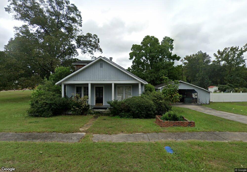
405 River Dr Rowesville, SC 29133
Estimated Value: $79,000 - $301,000
3
Beds
2
Baths
1,520
Sq Ft
$111/Sq Ft
Est. Value
About This Home
This home is located at 405 River Dr, Rowesville, SC 29133 and is currently estimated at $168,874, approximately $111 per square foot. 405 River Dr is a home located in Orangeburg County with nearby schools including Rivelon Elementary, Mellichamp Elementary, and Robert E. Howard Middle School.
Ownership History
Date
Name
Owned For
Owner Type
Purchase Details
Closed on
Apr 29, 2014
Sold by
Thompson Keith
Bought by
Thompson Angela O
Current Estimated Value
Purchase Details
Closed on
Nov 14, 2012
Sold by
Branch Banking & Trust Company
Bought by
Thompson Keith
Purchase Details
Closed on
Dec 5, 2011
Sold by
Keith Barry C
Bought by
Branch Banking & Trust Company
Purchase Details
Closed on
May 4, 2007
Sold by
Branch Banking & Trust Co
Bought by
Keith Barry
Purchase Details
Closed on
Oct 4, 2004
Sold by
Hud
Bought by
Branch Banking & Trust Co
Purchase Details
Closed on
Apr 20, 2004
Sold by
Derrick Sheila A
Bought by
Hud
Purchase Details
Closed on
Sep 22, 2000
Sold by
Green Wayne and Green Ericia Gomez
Bought by
Derrick Sheila A
Create a Home Valuation Report for This Property
The Home Valuation Report is an in-depth analysis detailing your home's value as well as a comparison with similar homes in the area
Purchase History
| Date | Buyer | Sale Price | Title Company |
|---|---|---|---|
| Thompson Angela O | -- | -- | |
| Thompson Keith | $20,000 | -- | |
| Branch Banking & Trust Company | $23,400 | -- | |
| Keith Barry | $21,500 | None Available | |
| Branch Banking & Trust Co | -- | -- | |
| Hud | $2,500 | -- | |
| Derrick Sheila A | $60,000 | -- |
Source: Public Records
Tax History
| Year | Tax Paid | Tax Assessment Tax Assessment Total Assessment is a certain percentage of the fair market value that is determined by local assessors to be the total taxable value of land and additions on the property. | Land | Improvement |
|---|---|---|---|---|
| 2024 | $935 | $3,940 | $239 | $3,701 |
| 2023 | $826 | $5,149 | $355 | $4,794 |
| 2022 | $809 | $5,149 | $355 | $4,794 |
| 2021 | $799 | $5,149 | $355 | $4,794 |
| 2020 | $785 | $5,149 | $0 | $0 |
| 2019 | $788 | $5,149 | $0 | $0 |
| 2018 | $739 | $5,047 | $0 | $0 |
| 2017 | $715 | $5,047 | $0 | $0 |
| 2016 | $715 | $5,047 | $0 | $0 |
| 2015 | $2,137 | $5,047 | $0 | $0 |
| 2014 | $2,137 | $5,047 | $355 | $4,692 |
| 2013 | -- | $3,096 | $236 | $2,860 |
Source: Public Records
Map
Nearby Homes
- 703 Calhoun St
- 115 Rowes Pump Dr
- 4003 Rowesville Rd
- TBD Bay Rd
- 319 Hewitt Rd
- 408 Cattle Creek Rd
- 17 Knotty Pine
- 29 Meadowcrest Dr
- 37 Pine Loop
- 36 Pine Loop
- 38 Pine Loop
- 183 Baycreek Ln
- 266 State Road S-38-75
- 203 Podium Rd
- 135 Terry St
- 136 Highland Park Cir
- 118 Highland Park Cir
- 257 Gass Rd
- 220 Ivory St
- 1983 Cannon Bridge Rd
Your Personal Tour Guide
Ask me questions while you tour the home.