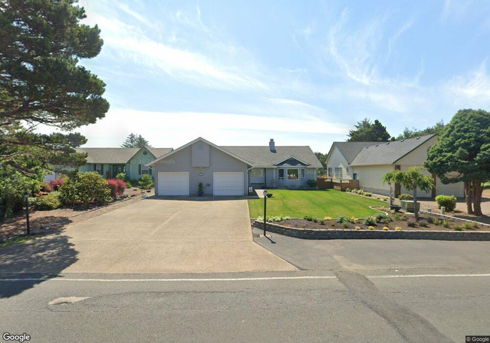
405 SW Range Dr Waldport, OR 97394
Estimated Value: $561,000 - $651,000
3
Beds
2
Baths
2,201
Sq Ft
$274/Sq Ft
Est. Value
About This Home
This home is located at 405 SW Range Dr, Waldport, OR 97394 and is currently estimated at $602,463, approximately $273 per square foot. 405 SW Range Dr is a home located in Lincoln County with nearby schools including Crestview Heights School, Waldport High and Middle School, and Angell JCC.
Ownership History
Date
Name
Owned For
Owner Type
Purchase Details
Closed on
Apr 25, 2019
Sold by
Waldo Delores B
Bought by
Booth Richard W and Booth Kaye S
Current Estimated Value
Home Financials for this Owner
Home Financials are based on the most recent Mortgage that was taken out on this home.
Original Mortgage
$217,988
Outstanding Balance
$189,656
Interest Rate
4%
Mortgage Type
New Conventional
Estimated Equity
$412,807
Create a Home Valuation Report for This Property
The Home Valuation Report is an in-depth analysis detailing your home's value as well as a comparison with similar homes in the area
Home Values in the Area
Average Home Value in this Area
Purchase History
| Date | Buyer | Sale Price | Title Company |
|---|---|---|---|
| Booth Richard W | $337,000 | None Available |
Source: Public Records
Mortgage History
| Date | Status | Borrower | Loan Amount |
|---|---|---|---|
| Open | Booth Richard W | $217,988 |
Source: Public Records
Tax History Compared to Growth
Tax History
| Year | Tax Paid | Tax Assessment Tax Assessment Total Assessment is a certain percentage of the fair market value that is determined by local assessors to be the total taxable value of land and additions on the property. | Land | Improvement |
|---|---|---|---|---|
| 2025 | $6,195 | $362,610 | -- | -- |
| 2024 | $5,865 | $352,050 | -- | -- |
| 2023 | $5,694 | $341,800 | $0 | $0 |
| 2022 | $5,499 | $331,850 | $0 | $0 |
| 2021 | $5,361 | $322,190 | $0 | $0 |
| 2020 | $5,255 | $312,810 | $0 | $0 |
| 2019 | $5,056 | $303,700 | $0 | $0 |
| 2018 | $4,603 | $273,480 | $0 | $0 |
| 2017 | $4,455 | $265,520 | $0 | $0 |
| 2016 | $4,345 | $257,790 | $0 | $0 |
| 2015 | $3,609 | $250,190 | $0 | $0 |
| 2014 | $3,622 | $250,860 | $0 | $0 |
| 2013 | -- | $245,020 | $0 | $0 |
Source: Public Records
Map
Nearby Homes
- 415 SW Range Dr
- 1410 SW Forest Pkwy
- 125 SW Range Dr
- 1420 SW Fairway Dr
- 1590 SW Fairway Dr
- 1345 SW Fairway Dr
- TL 10200 SW Chad Dr
- 760 SW Range Dr
- 700 Blk SW Kelsie Ln
- 1445 S Crestline Dr
- 2220 SW Green Ln
- 925 SW Dolores Dr
- 1200 Blk Sw Norwood Drive Tl0120
- 165 SE Rose St
- 1200 Blk Norwood Dr Tl012
- TL 300 SW Dolores Dr
- 2520 S Crestline Dr
- 600 SW Pacific Coast Hwy
- 125 SW View Dr
- TL 600 SW Sailfish Loop
- 355 SW Range Dr
- 335 SW Range Dr
- 455 SW Range Dr
- 360 SW Range Dr
- 380 SW Range Dr
- 305 SW Range Dr
- 340 SW Range Dr
- 440 SW Range Dr
- 320 SW Range Dr
- 460 SW Range Dr
- 295 SW Range Dr
- 365 SW Double Eagle Dr
- 345 Double Eagle
- 345 SW Double Eagle Dr
- 385 SW Double Eagle Dr
- 480 SW Range Dr
- 1540 SW Masters Dr
- 285 SW Range Dr
- 465 SW Double Eagle Dr
- 465 Double Eagle