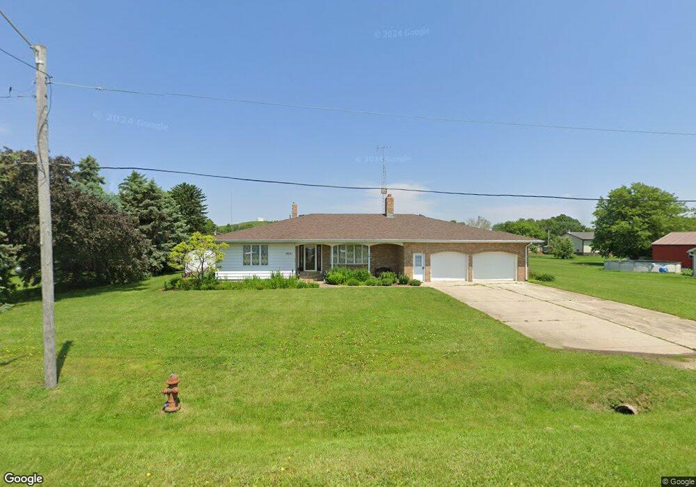
405 W Division St Anthon, IA 51004
Estimated Value: $233,000 - $274,711
3
Beds
3
Baths
2,170
Sq Ft
$116/Sq Ft
Est. Value
About This Home
This home is located at 405 W Division St, Anthon, IA 51004 and is currently estimated at $251,928, approximately $116 per square foot. 405 W Division St is a home located in Woodbury County with nearby schools including Anthon Elementary School, Mvao Middle School, and Maple Valley-Anthon Oto High School.
Ownership History
Date
Name
Owned For
Owner Type
Purchase Details
Closed on
Nov 6, 2025
Sold by
Parker Frank
Bought by
Frank Parker Revocable Trust and Parker
Current Estimated Value
Purchase Details
Closed on
Oct 28, 2025
Sold by
Parker Dorothy E
Bought by
Walsh Charlotte R and Parker Frank A
Purchase Details
Closed on
May 16, 2025
Sold by
Parker Frank
Bought by
Frank Parker Revocable Trust and Parker
Create a Home Valuation Report for This Property
The Home Valuation Report is an in-depth analysis detailing your home's value as well as a comparison with similar homes in the area
Purchase History
We collect this data history from publicly available records. To have your information removed, we recommend requesting removal directly through your county’s website.
| Date | Buyer | Sale Price | Title Company |
|---|---|---|---|
| Frank Parker Revocable Trust | -- | None Listed On Document | |
| Walsh Charlotte R | -- | None Listed On Document | |
| Frank Parker Revocable Trust | -- | None Listed On Document |
Source: Public Records
Tax History
| Year | Tax Paid | Tax Assessment Tax Assessment Total Assessment is a certain percentage of the fair market value that is determined by local assessors to be the total taxable value of land and additions on the property. | Land | Improvement |
|---|---|---|---|---|
| 2025 | $2,812 | $244,730 | $11,960 | $232,770 |
| 2024 | $27 | $212,400 | $11,960 | $200,440 |
| 2023 | $2,608 | $212,400 | $11,960 | $200,440 |
| 2022 | $2,548 | $163,030 | $11,960 | $151,070 |
| 2021 | $2,548 | $163,030 | $11,960 | $151,070 |
| 2020 | $2,562 | $156,820 | $12,800 | $144,020 |
| 2019 | $2,662 | $156,820 | $12,800 | $144,020 |
| 2018 | $2,632 | $156,820 | $12,800 | $144,020 |
| 2017 | $2,674 | $156,820 | $12,800 | $144,020 |
| 2016 | $2,604 | $156,820 | $0 | $0 |
| 2015 | $2,436 | $146,560 | $11,960 | $134,600 |
Source: Public Records
Map
Nearby Homes
- 208 Westgate Ave
- 300 Westgate Rd
- 206 Westgate Ave
- 106 Westgate Rd
- 207 Westgate Rd
- 207 Westgate Ave
- 301 Westgate Rd
- 205 Westgate Ave
- 303 Westgate Rd
- 304 Westgate Rd
- 104 Westgate Rd
- 501 W Division St
- 115 Westgate Rd
- 305 Westgate Rd
- 109 Westgate Rd
- 111 Westgate Rd
- 107 Westgate Rd
- 102 Westgate Rd
- 403 W Division St
- 105 Westgate Rd
Your Personal Tour Guide
Ask me questions while you tour the home.