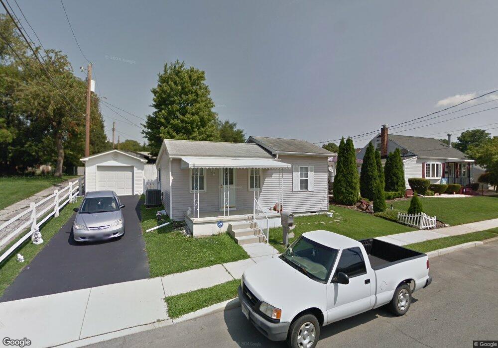
406 Brookline Ave Hagerstown, MD 21740
East End NeighborhoodEstimated Value: $162,251 - $231,000
Studio
1
Bath
692
Sq Ft
$298/Sq Ft
Est. Value
About This Home
This home is located at 406 Brookline Ave, Hagerstown, MD 21740 and is currently estimated at $206,063, approximately $297 per square foot. 406 Brookline Ave is a home located in Washington County with nearby schools including Pangborn Elementary School, Northern Middle School, and North Hagerstown High School.
Ownership History
Date
Name
Owned For
Owner Type
Purchase Details
Closed on
Aug 15, 1994
Sold by
Heiks S D
Bought by
Pleasant Tammy L
Current Estimated Value
Home Financials for this Owner
Home Financials are based on the most recent Mortgage that was taken out on this home.
Original Mortgage
$35,071
Interest Rate
8.52%
Purchase Details
Closed on
Jan 8, 1992
Sold by
Leatherman Paul W
Bought by
Heiks Scott B
Home Financials for this Owner
Home Financials are based on the most recent Mortgage that was taken out on this home.
Original Mortgage
$19,950
Interest Rate
8.24%
Create a Home Valuation Report for This Property
The Home Valuation Report is an in-depth analysis detailing your home's value as well as a comparison with similar homes in the area
Home Values in the Area
Average Home Value in this Area
Purchase History
| Date | Buyer | Sale Price | Title Company |
|---|---|---|---|
| Pleasant Tammy L | $34,000 | -- | |
| Heiks Scott B | $22,200 | -- |
Source: Public Records
Mortgage History
| Date | Status | Borrower | Loan Amount |
|---|---|---|---|
| Closed | Pleasant Tammy L | $35,071 | |
| Previous Owner | Heiks Scott B | $19,950 |
Source: Public Records
Tax History
| Year | Tax Paid | Tax Assessment Tax Assessment Total Assessment is a certain percentage of the fair market value that is determined by local assessors to be the total taxable value of land and additions on the property. | Land | Improvement |
|---|---|---|---|---|
| 2025 | $1,004 | $142,900 | $34,000 | $108,900 |
| 2024 | $1,004 | $126,733 | $0 | $0 |
| 2023 | $956 | $110,567 | $0 | $0 |
| 2022 | $911 | $94,400 | $34,000 | $60,400 |
| 2021 | $826 | $89,167 | $0 | $0 |
| 2020 | $826 | $83,933 | $0 | $0 |
| 2019 | $787 | $78,700 | $34,000 | $44,700 |
| 2018 | $931 | $77,767 | $0 | $0 |
| 2017 | $693 | $76,833 | $0 | $0 |
| 2016 | -- | $75,900 | $0 | $0 |
| 2015 | -- | $75,900 | $0 | $0 |
| 2014 | $986 | $75,900 | $0 | $0 |
Source: Public Records
Map
Nearby Homes
- 713 Medway Rd
- 747 Monet Dr
- 613 Westwood St
- 761 Jefferson Blvd
- 466 Pangborn Blvd
- 43 Sunbrook Ln Unit 6
- 528 Jefferson St
- 946 Monet Dr
- 319 Sunbrook Ln Unit 98
- 838 Mulberry Ave
- 1001 Jefferson Blvd
- 522 N Mulberry St
- 939 View St
- 629 N Mulberry St
- 250 Sunbrook Ln Unit 132
- 953 View St
- 101 N Cleveland Ave
- 109 111 Fairground Ave
- 445 E Franklin St
- 35 N Cleveland Ave
- 704 Medway Rd
- 400 Brookline Ave
- 412 Brookline Ave
- 708 Medway Rd
- 417 Brookline Ave
- 420 Brookline Ave
- 401 Brookline Ave
- 712 Medway Rd
- 711 Park Rd
- 716 Medway Rd
- 655 Security Rd
- 350 Brookline Ave
- 705 Medway Rd
- 721 Park Rd
- 724 Medway Rd
- 351 Brookline Ave
- 707 Medway Rd
- 715 Medway Rd
- 701 Security Rd
- 636 Medway Rd
Your Personal Tour Guide
Ask me questions while you tour the home.