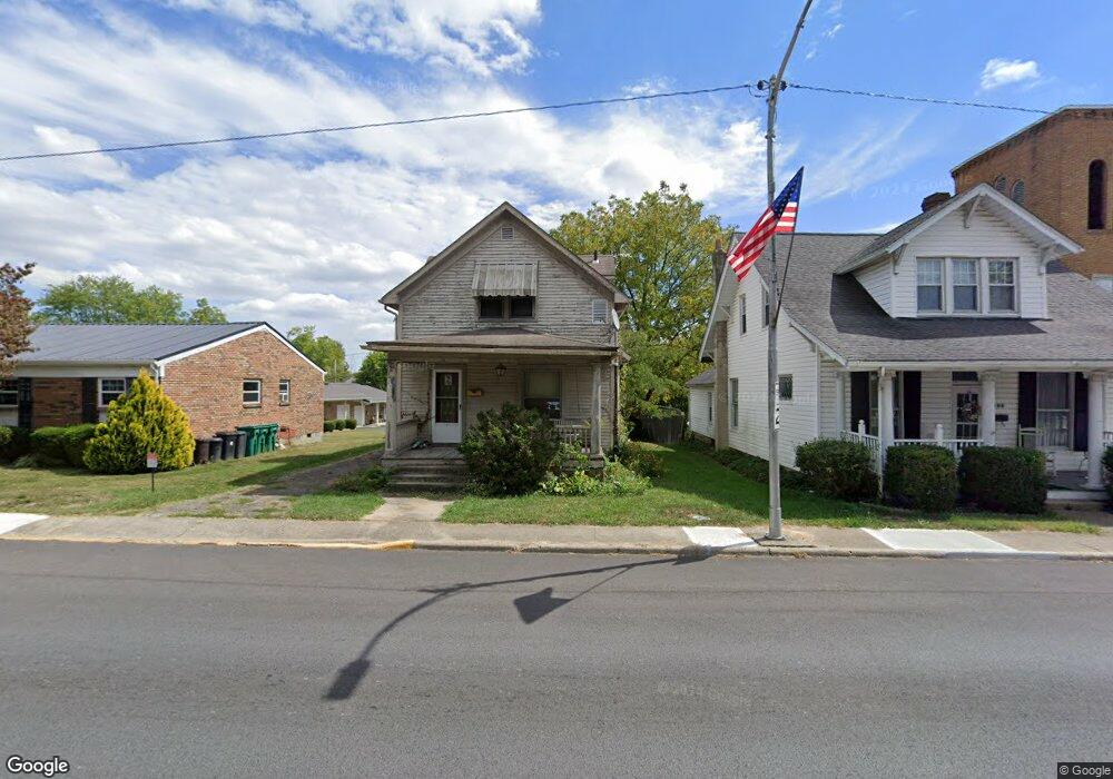
406 N Main St Georgetown, OH 45121
Estimated Value: $122,000 - $175,000
2
Beds
1
Bath
1,232
Sq Ft
$122/Sq Ft
Est. Value
About This Home
This home is located at 406 N Main St, Georgetown, OH 45121 and is currently estimated at $150,000, approximately $121 per square foot. 406 N Main St is a home located in Brown County with nearby schools including Georgetown Elementary School and Georgetown Jr/Sr High School.
Ownership History
Date
Name
Owned For
Owner Type
Purchase Details
Closed on
Jan 24, 2002
Sold by
Murrell Benjamin G
Bought by
Rhoten Amber L
Current Estimated Value
Home Financials for this Owner
Home Financials are based on the most recent Mortgage that was taken out on this home.
Original Mortgage
$55,200
Outstanding Balance
$22,986
Interest Rate
7.16%
Mortgage Type
New Conventional
Estimated Equity
$127,014
Purchase Details
Closed on
Jun 14, 2000
Sold by
Dotson Randy L
Bought by
Murrell Benjamin G and Murrell Annie L
Home Financials for this Owner
Home Financials are based on the most recent Mortgage that was taken out on this home.
Original Mortgage
$55,000
Interest Rate
8.31%
Mortgage Type
New Conventional
Purchase Details
Closed on
Jul 3, 1997
Sold by
Tolin James H
Bought by
Dotson Randy L and Tolin Megan R
Home Financials for this Owner
Home Financials are based on the most recent Mortgage that was taken out on this home.
Original Mortgage
$42,000
Interest Rate
8.01%
Mortgage Type
New Conventional
Create a Home Valuation Report for This Property
The Home Valuation Report is an in-depth analysis detailing your home's value as well as a comparison with similar homes in the area
Home Values in the Area
Average Home Value in this Area
Purchase History
| Date | Buyer | Sale Price | Title Company |
|---|---|---|---|
| Rhoten Amber L | $55,000 | -- | |
| Murrell Benjamin G | $55,000 | -- | |
| Dotson Randy L | $22,800 | -- |
Source: Public Records
Mortgage History
| Date | Status | Borrower | Loan Amount |
|---|---|---|---|
| Open | Rhoten Amber L | $55,200 | |
| Previous Owner | Murrell Benjamin G | $55,000 | |
| Previous Owner | Dotson Randy L | $42,000 |
Source: Public Records
Tax History
| Year | Tax Paid | Tax Assessment Tax Assessment Total Assessment is a certain percentage of the fair market value that is determined by local assessors to be the total taxable value of land and additions on the property. | Land | Improvement |
|---|---|---|---|---|
| 2024 | $841 | $23,760 | $4,140 | $19,620 |
| 2023 | $842 | $17,970 | $3,440 | $14,530 |
| 2022 | $693 | $17,970 | $3,440 | $14,530 |
| 2021 | $687 | $17,970 | $3,440 | $14,530 |
| 2020 | $608 | $14,990 | $2,880 | $12,110 |
| 2019 | $302 | $14,990 | $2,880 | $12,110 |
| 2018 | $600 | $14,990 | $2,880 | $12,110 |
| 2017 | $470 | $13,960 | $3,160 | $10,800 |
| 2016 | $470 | $13,960 | $3,160 | $10,800 |
| 2015 | $476 | $13,960 | $3,160 | $10,800 |
| 2014 | $486 | $13,680 | $2,880 | $10,800 |
| 2013 | $485 | $13,680 | $2,880 | $10,800 |
Source: Public Records
Map
Nearby Homes
- 405 N Main St
- 508 Mount Orab Pike
- 399 Elmwood Ct
- 406 E North St
- 60 New St
- 505 S Water St
- 510 W State St
- 427 Kenwood Ave
- 1 N Kenwood Ave
- 2 N Kenwood Ave
- 666 E State St
- 708 E State St
- 25 Douglas Ln
- 0 St Rt 221 & Footbridge Unit 1826509
- 155 Free Soil Rd
- 20 Heritage Hill Dr
- 175 Douglas Cir
- 38 Dell Acres Dr
- 470 Free Soil Rd
- 7480 Old Us Highway 68
Your Personal Tour Guide
Ask me questions while you tour the home.