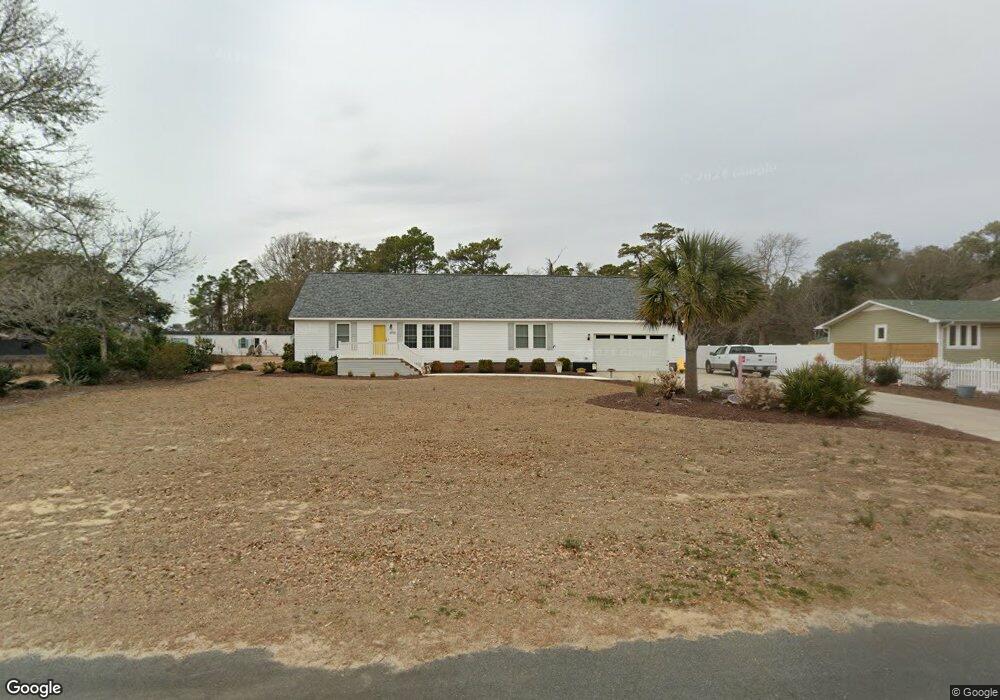
406 Pearson Cir Newport, NC 28570
Estimated Value: $524,446 - $637,000
4
Beds
3
Baths
2,446
Sq Ft
$239/Sq Ft
Est. Value
About This Home
This home is located at 406 Pearson Cir, Newport, NC 28570 and is currently estimated at $583,862, approximately $238 per square foot. 406 Pearson Cir is a home located in Carteret County with nearby schools including Bogue Sound Elementary School, Broad Creek Middle School, and Croatan High School.
Ownership History
Date
Name
Owned For
Owner Type
Purchase Details
Closed on
Aug 1, 2024
Sold by
Narron Judy Tedder and Narron Ralph J
Bought by
Kopp Sharon Marie and Kopp Travis Eugene
Current Estimated Value
Home Financials for this Owner
Home Financials are based on the most recent Mortgage that was taken out on this home.
Original Mortgage
$382,400
Outstanding Balance
$378,073
Interest Rate
6.87%
Mortgage Type
New Conventional
Estimated Equity
$205,789
Create a Home Valuation Report for This Property
The Home Valuation Report is an in-depth analysis detailing your home's value as well as a comparison with similar homes in the area
Home Values in the Area
Average Home Value in this Area
Purchase History
| Date | Buyer | Sale Price | Title Company |
|---|---|---|---|
| Kopp Sharon Marie | -- | None Listed On Document | |
| Kopp Sharon Marie | -- | None Listed On Document |
Source: Public Records
Mortgage History
| Date | Status | Borrower | Loan Amount |
|---|---|---|---|
| Open | Kopp Sharon Marie | $382,400 | |
| Closed | Kopp Sharon Marie | $382,400 |
Source: Public Records
Tax History
| Year | Tax Paid | Tax Assessment Tax Assessment Total Assessment is a certain percentage of the fair market value that is determined by local assessors to be the total taxable value of land and additions on the property. | Land | Improvement |
|---|---|---|---|---|
| 2025 | $1,679 | $518,201 | $119,664 | $398,537 |
| 2024 | $1,428 | $302,252 | $84,042 | $218,210 |
| 2023 | $1,502 | $302,252 | $84,042 | $218,210 |
| 2022 | $1,472 | $302,252 | $84,042 | $218,210 |
| 2021 | $1,411 | $302,252 | $84,042 | $218,210 |
| 2020 | $978 | $194,544 | $84,042 | $110,502 |
| 2019 | $959 | $199,803 | $84,042 | $115,761 |
| 2017 | $959 | $199,803 | $84,042 | $115,761 |
| 2016 | $959 | $199,803 | $84,042 | $115,761 |
| 2015 | $899 | $199,803 | $84,042 | $115,761 |
| 2014 | $795 | $216,664 | $96,642 | $120,022 |
Source: Public Records
Map
Nearby Homes
- 444 Pearson Cir
- 450 Pearson Cir
- 264 Pearson Cir
- 200 Pelican Dr
- 134 Water Ln
- 108 Henderson Dr
- 106 Key West Ln
- 111 Key West Ln
- 109 Key West Ln
- 275 Salty Shores Rd
- 147 Salty Shores Point Dr
- 180 Salty Shores Point Dr
- 180 Henderson Dr
- 229 Cottontail Run
- 173 Salter Dr
- 213 Nine Mile Rd
- 516 Blue Heron Dr
- 309 Island View Dr
- 220 Sequoia Dr Unit 263
- 103 Port Ln
- 406 & 410 Pearson Cir
- 420 Pearson Cir
- 400 Pearson Cir
- 390 Pearson Cir
- 430 Pearson Cir
- 401 Pearson Cir
- 413 Pearson Cir
- 419 Pearson Cir
- 407 Pearson Cir
- 389 Pearson Cir
- 380 Pearson Cir
- 425 Pearson Cir
- 395 Pearson Cir
- 372 Pearson Cir
- 441 Pearson Cir
- 500 Pearson Cir
- 512 Pearson Cir
- 366 Pearson Cir
- 447 Pearson Cir
- 377 Pearson Cir
Your Personal Tour Guide
Ask me questions while you tour the home.