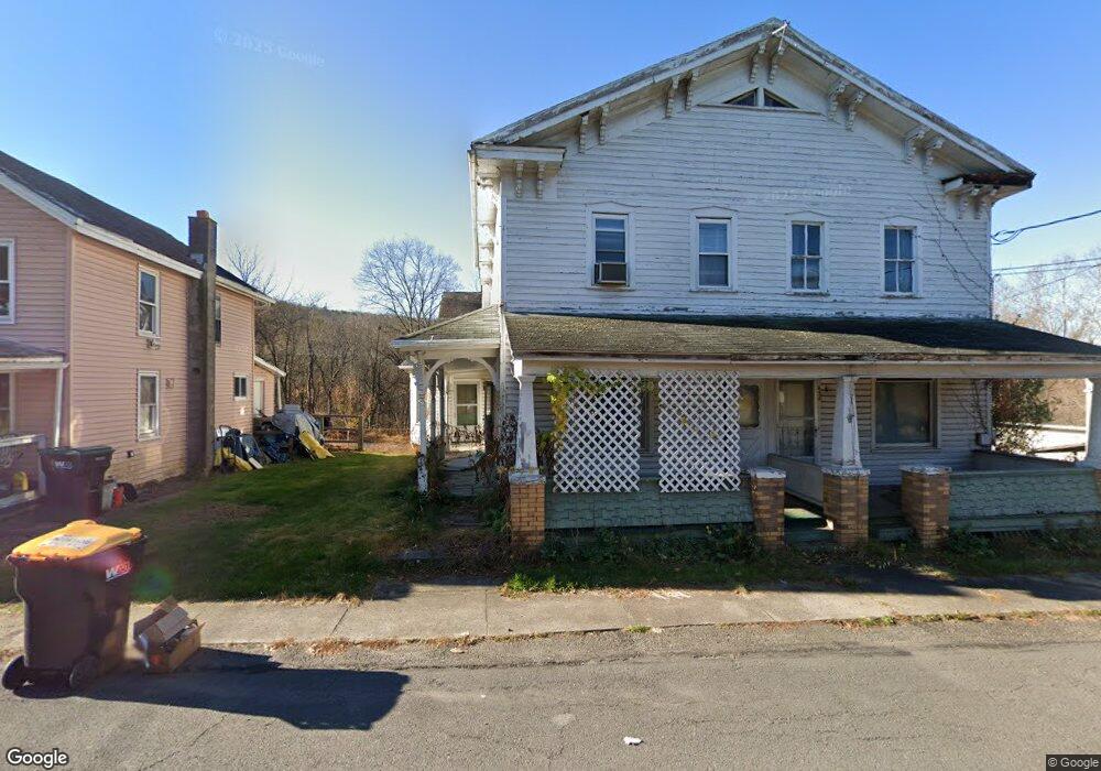
406 S Main St Wapwallopen, PA 18660
Estimated Value: $102,000 - $243,000
--
Bed
--
Bath
1,152
Sq Ft
$139/Sq Ft
Est. Value
About This Home
This home is located at 406 S Main St, Wapwallopen, PA 18660 and is currently estimated at $160,027, approximately $138 per square foot. 406 S Main St is a home located in Luzerne County with nearby schools including Kennedy Early Childhood Center, Nanticoke Area Elementary Center Center, and Greater Nanticoke Area Senior High School.
Ownership History
Date
Name
Owned For
Owner Type
Purchase Details
Closed on
Jul 25, 2022
Sold by
Terry Hower
Bought by
Renaud Gary L
Current Estimated Value
Home Financials for this Owner
Home Financials are based on the most recent Mortgage that was taken out on this home.
Original Mortgage
$61,000
Outstanding Balance
$57,860
Interest Rate
4.75%
Mortgage Type
New Conventional
Estimated Equity
$102,167
Purchase Details
Closed on
Oct 3, 2008
Sold by
Renaud Nicole L and Renaud Nichole L
Bought by
Hower Terry and Hower Linda
Home Financials for this Owner
Home Financials are based on the most recent Mortgage that was taken out on this home.
Original Mortgage
$72,200
Interest Rate
6.43%
Mortgage Type
Purchase Money Mortgage
Purchase Details
Closed on
Aug 7, 2006
Sold by
Beaver Michael J and Beaver Nicole L
Bought by
Reo Management 2004 Inc
Create a Home Valuation Report for This Property
The Home Valuation Report is an in-depth analysis detailing your home's value as well as a comparison with similar homes in the area
Home Values in the Area
Average Home Value in this Area
Purchase History
| Date | Buyer | Sale Price | Title Company |
|---|---|---|---|
| Renaud Gary L | $85,000 | None Listed On Document | |
| Hower Terry | $76,000 | None Available | |
| Reo Management 2004 Inc | $1,635 | None Available |
Source: Public Records
Mortgage History
| Date | Status | Borrower | Loan Amount |
|---|---|---|---|
| Open | Renaud Gary L | $61,000 | |
| Previous Owner | Hower Terry | $72,200 |
Source: Public Records
Tax History Compared to Growth
Tax History
| Year | Tax Paid | Tax Assessment Tax Assessment Total Assessment is a certain percentage of the fair market value that is determined by local assessors to be the total taxable value of land and additions on the property. | Land | Improvement |
|---|---|---|---|---|
| 2025 | $1,793 | $85,200 | $17,900 | $67,300 |
| 2024 | $1,793 | $85,200 | $17,900 | $67,300 |
| 2023 | $1,762 | $85,200 | $17,900 | $67,300 |
| 2022 | $1,746 | $85,200 | $17,900 | $67,300 |
| 2021 | $1,700 | $85,200 | $17,900 | $67,300 |
| 2020 | $1,700 | $85,200 | $17,900 | $67,300 |
| 2019 | $1,684 | $85,200 | $17,900 | $67,300 |
| 2018 | $1,627 | $85,200 | $17,900 | $67,300 |
| 2017 | $1,570 | $85,200 | $17,900 | $67,300 |
| 2016 | -- | $85,200 | $17,900 | $67,300 |
| 2015 | $1,199 | $85,200 | $17,900 | $67,300 |
| 2014 | $1,199 | $85,200 | $17,900 | $67,300 |
Source: Public Records
Map
Nearby Homes
- 494 S River St
- 49 Hillside Ln
- 88 Walnut Dr
- Lot 18 Ruckle Hill Rd
- 76 Hazleton-Berwick Hwy
- 71 3rd Ln
- 31 2nd Ln
- 10 Rear Old Berwick (Burma Rd) Rd
- 16 Cindy Dr
- LOT NO. 8 Collister Dr Rd
- 329 Vine St
- 371 Pond Hill Mountain Rd
- 941 E 1st St
- 929 Mifflin Ave
- 74 Maple St
- 12 Maple St
- 3 Maple St
- 77 Maple St
- 11 Maple St
- 37 Maple St