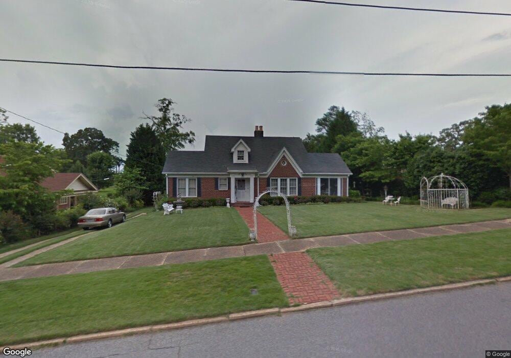
406 W 3rd St Manchester, GA 31816
Estimated Value: $145,344 - $161,000
3
Beds
2
Baths
1,724
Sq Ft
$88/Sq Ft
Est. Value
About This Home
This home is located at 406 W 3rd St, Manchester, GA 31816 and is currently estimated at $151,086, approximately $87 per square foot. 406 W 3rd St is a home located in Meriwether County with nearby schools including Mountain View Elementary School, Manchester Middle School, and Manchester High School.
Ownership History
Date
Name
Owned For
Owner Type
Purchase Details
Closed on
Aug 29, 2018
Sold by
Bryant Mary L
Bought by
Engler Sandra G
Current Estimated Value
Purchase Details
Closed on
Feb 12, 2013
Sold by
Stanford Debra B
Bought by
Bryant Mary L
Purchase Details
Closed on
Jan 29, 2007
Sold by
Not Provided
Bought by
Stanford Debra Bryant
Purchase Details
Closed on
Sep 8, 1999
Sold by
Bryant William C
Bought by
Bryant William C and Bryant M
Purchase Details
Closed on
Jan 1, 1990
Bought by
Bryant William C
Create a Home Valuation Report for This Property
The Home Valuation Report is an in-depth analysis detailing your home's value as well as a comparison with similar homes in the area
Home Values in the Area
Average Home Value in this Area
Purchase History
| Date | Buyer | Sale Price | Title Company |
|---|---|---|---|
| Engler Sandra G | $75,000 | -- | |
| Bryant Mary L | -- | -- | |
| Stanford Debra Bryant | -- | -- | |
| Bryant William C | -- | -- | |
| Bryant William C | -- | -- |
Source: Public Records
Tax History Compared to Growth
Tax History
| Year | Tax Paid | Tax Assessment Tax Assessment Total Assessment is a certain percentage of the fair market value that is determined by local assessors to be the total taxable value of land and additions on the property. | Land | Improvement |
|---|---|---|---|---|
| 2024 | $2,310 | $48,960 | $3,080 | $45,880 |
| 2023 | $1,539 | $31,760 | $3,080 | $28,680 |
| 2022 | $1,539 | $31,760 | $3,080 | $28,680 |
| 2021 | $1,013 | $31,760 | $3,080 | $28,680 |
| 2020 | $779 | $31,760 | $3,080 | $28,680 |
| 2019 | $725 | $31,760 | $3,080 | $28,680 |
| 2018 | $1,035 | $34,840 | $3,080 | $31,760 |
| 2017 | $705 | $21,360 | $1,800 | $19,560 |
| 2016 | $456 | $21,360 | $1,800 | $19,560 |
| 2015 | $512 | $23,040 | $1,800 | $21,240 |
| 2014 | $674 | $27,960 | $3,480 | $24,480 |
| 2013 | -- | $37,400 | $3,480 | $33,920 |
Source: Public Records
Map
Nearby Homes
- 13.27 ACRES Roosevelt Hwy
- 304 4th St
- 522 4th St
- 408 Broad St
- 514 Farris Blvd
- 919 L S Glencamp Way
- 617 Mayes Way
- 12 Truitt St
- 604 Farris Blvd
- 621 Mayes Way
- 802 Jd Parham Dr
- 322 Chalybeate St
- 3.26 ACRES Mountain Ridge Dr
- 434 Parkman Dr
- 305 Holy Hill Place
- 200 Hunt Cir
- 94 Cato St
- 900 Mountain Ridge Dr Unit 4.89 ACRES
- 77 Cordwood St
- 16 North St
- 410 W 3rd St
- 0 3rd St Unit 10135284
- 0 3rd St Unit 8790441
- 0 3rd St Unit 8396590
- 0 3rd St Unit 7450444
- 0 3rd St Unit 7102836
- 0 3rd St Unit 3212286
- W 3rd St
- 3rd 3rd St
- 400 W 3rd St
- 414 W 3rd St
- 204 4th Ave Unit LOT 1&2
- 204 4th Ave
- 416 W 3rd St
- 407 W 3rd St
- 405 W 3rd St
- 411 W 2nd St
- 411 W 3rd St
- 413 W 3rd St
- 418 W 3rd St