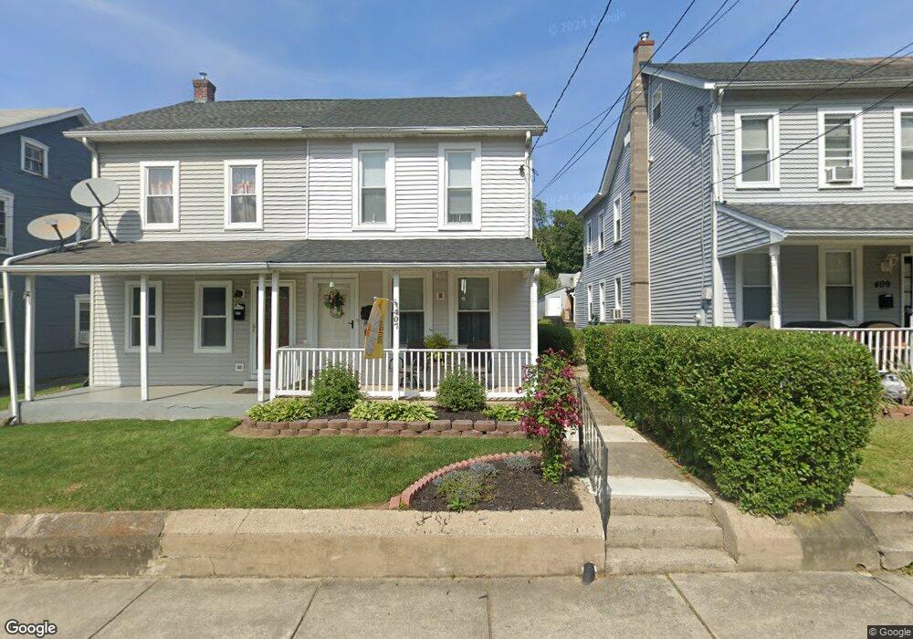
407 S 7th St Emmaus, PA 18049
Estimated Value: $228,504 - $260,000
3
Beds
1
Bath
1,344
Sq Ft
$183/Sq Ft
Est. Value
About This Home
This home is located at 407 S 7th St, Emmaus, PA 18049 and is currently estimated at $245,876, approximately $182 per square foot. 407 S 7th St is a home located in Lehigh County with nearby schools including Lincoln Elementary School, Lower Macungie Middle School, and Emmaus High School.
Ownership History
Date
Name
Owned For
Owner Type
Purchase Details
Closed on
Aug 2, 2001
Sold by
Mackes Barbra A and Schwenk Barbra A
Bought by
Schwenk Richard H and Schwenk Barbra A
Current Estimated Value
Purchase Details
Closed on
Jul 28, 1997
Sold by
Mackes Kenneth W and Mackes Barbara A
Bought by
Mackes Barbra A
Purchase Details
Closed on
Nov 15, 1989
Sold by
Zack John R and Zack Kay L
Bought by
Mackes Kenneth W and Mackes Barbara A
Purchase Details
Closed on
May 30, 1985
Sold by
Kidd Mark D and Kidd Rhonda S
Bought by
Zack John R and Zack Kay L
Purchase Details
Closed on
Jun 24, 1977
Bought by
Kidd Mark D and Kidd Rhonda S
Create a Home Valuation Report for This Property
The Home Valuation Report is an in-depth analysis detailing your home's value as well as a comparison with similar homes in the area
Home Values in the Area
Average Home Value in this Area
Purchase History
| Date | Buyer | Sale Price | Title Company |
|---|---|---|---|
| Schwenk Richard H | -- | -- | |
| Mackes Barbra A | -- | -- | |
| Mackes Kenneth W | $70,000 | -- | |
| Zack John R | $47,000 | -- | |
| Kidd Mark D | $16,500 | -- |
Source: Public Records
Tax History Compared to Growth
Tax History
| Year | Tax Paid | Tax Assessment Tax Assessment Total Assessment is a certain percentage of the fair market value that is determined by local assessors to be the total taxable value of land and additions on the property. | Land | Improvement |
|---|---|---|---|---|
| 2025 | $3,473 | $98,600 | $14,900 | $83,700 |
| 2024 | $3,181 | $98,600 | $14,900 | $83,700 |
| 2023 | $3,120 | $98,600 | $14,900 | $83,700 |
| 2022 | $3,017 | $98,600 | $83,700 | $14,900 |
| 2021 | $2,941 | $98,600 | $14,900 | $83,700 |
| 2020 | $2,916 | $98,600 | $14,900 | $83,700 |
| 2019 | $2,838 | $98,600 | $14,900 | $83,700 |
| 2018 | $2,731 | $98,600 | $14,900 | $83,700 |
| 2017 | $2,647 | $98,600 | $14,900 | $83,700 |
| 2016 | -- | $98,600 | $14,900 | $83,700 |
| 2015 | -- | $98,600 | $14,900 | $83,700 |
| 2014 | -- | $98,600 | $14,900 | $83,700 |
Source: Public Records
Map
Nearby Homes
- 618 Broad St
- 659 Broad St
- 521 Wood St
- 569 Chestnut St Unit 571
- 657 Walnut St
- 339 Delong Ave Unit 343
- 97 Chestnut Hill Rd
- 543 Long St
- 120 N 2nd St
- 118 N 2nd St
- 4109 Eveningstar Rd
- 3430 Gentlewind Way Unit IC 109
- 4088 Eveningstar Rd
- 3623 Daylily Dr
- 101 E George St
- 4160 Newport Dr
- 3810 Allen St
- 2571 Brunner Rd
- 3989 Mink Rd
- 558 Beechwood St