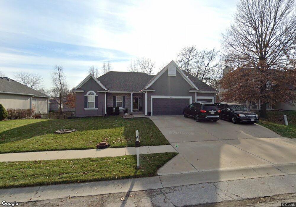
407 Shadowbrook Dr Kearney, MO 64060
Estimated Value: $419,904 - $435,000
3
Beds
3
Baths
1,635
Sq Ft
$262/Sq Ft
Est. Value
About This Home
This home is located at 407 Shadowbrook Dr, Kearney, MO 64060 and is currently estimated at $428,476, approximately $262 per square foot. 407 Shadowbrook Dr is a home located in Clay County with nearby schools including Kearney Junior High School, Kearney High School, and Northern Hills Christian Academy.
Ownership History
Date
Name
Owned For
Owner Type
Purchase Details
Closed on
Dec 24, 2008
Sold by
Hardekopf Don
Bought by
Hardekopf Don S
Current Estimated Value
Home Financials for this Owner
Home Financials are based on the most recent Mortgage that was taken out on this home.
Original Mortgage
$204,000
Outstanding Balance
$134,924
Interest Rate
6.15%
Mortgage Type
Stand Alone Refi Refinance Of Original Loan
Estimated Equity
$293,552
Purchase Details
Closed on
Jul 25, 2006
Sold by
Sommerhauser James
Bought by
Hardekopf Don
Purchase Details
Closed on
Jun 8, 2005
Sold by
Sommerhauser Cody
Bought by
Sommerhauser James
Purchase Details
Closed on
Jul 21, 2003
Sold by
Couchman Construction Inc
Bought by
Sommerhauser James F and Sommerhauser Cody L
Home Financials for this Owner
Home Financials are based on the most recent Mortgage that was taken out on this home.
Original Mortgage
$171,900
Interest Rate
5.15%
Mortgage Type
Purchase Money Mortgage
Create a Home Valuation Report for This Property
The Home Valuation Report is an in-depth analysis detailing your home's value as well as a comparison with similar homes in the area
Home Values in the Area
Average Home Value in this Area
Purchase History
| Date | Buyer | Sale Price | Title Company |
|---|---|---|---|
| Hardekopf Don S | -- | None Available | |
| Hardekopf Don | -- | Old Republic Title | |
| Sommerhauser James | -- | -- | |
| Sommerhauser James F | -- | Thomson Title Corporation |
Source: Public Records
Mortgage History
| Date | Status | Borrower | Loan Amount |
|---|---|---|---|
| Open | Hardekopf Don S | $204,000 | |
| Previous Owner | Sommerhauser James F | $171,900 |
Source: Public Records
Tax History
| Year | Tax Paid | Tax Assessment Tax Assessment Total Assessment is a certain percentage of the fair market value that is determined by local assessors to be the total taxable value of land and additions on the property. | Land | Improvement |
|---|---|---|---|---|
| 2025 | $3,976 | $66,650 | -- | -- |
| 2024 | $3,976 | $58,010 | -- | -- |
| 2023 | $3,962 | $58,010 | $0 | $0 |
| 2022 | $3,652 | $51,700 | $0 | $0 |
| 2021 | $3,579 | $51,699 | $5,130 | $46,569 |
| 2020 | $3,649 | $47,940 | $0 | $0 |
| 2019 | $3,630 | $47,940 | $0 | $0 |
| 2018 | $3,401 | $43,380 | $0 | $0 |
| 2017 | $3,365 | $43,380 | $5,130 | $38,250 |
| 2016 | $3,365 | $43,380 | $5,130 | $38,250 |
| 2015 | $3,365 | $43,380 | $5,130 | $38,250 |
| 2014 | $3,325 | $42,660 | $5,700 | $36,960 |
Source: Public Records
Map
Nearby Homes
- 1302 Regency Dr
- 307 W 11th Terrace
- 303 W 11th St
- 1304 S Jefferson St
- 1845 Falcon Ct
- 200 E 10th St
- 2001 Foxtail Point
- 402 E 14th St
- 1933 Meadowlane
- 2101 S Petty Rd
- 1300 Robin Cir
- 2101 Crooked Creek Dr
- 2318 Foxtail Dr
- 2314 Foxtail Dr
- 2317 Foxtail Dr
- 2354 Foxtail Dr
- 2326 Foxtail Dr
- 2325 Foxtail Dr
- 2312 Foxtail Dr
- 2307 Foxtail Dr
- 405 Shadowbrook Dr
- 409 Shadowbrook Dr
- 408 Lee Dr
- 406 Lee Dr
- 1204 Brookwood Dr
- 411 Shadowbrook Dr
- 403 Shadowbrook Dr
- 410 Lee Dr
- 404 Lee Dr
- 404 Shadowbrook Dr
- 412 Lee Dr
- 1205 Silhouette Dr
- 1202 Brookwood Dr
- 401 Shadowbrook Dr
- 402 Lee Dr
- 402 Shadowbrook Dr
- 1203 Silhouette Dr
- 1200 Brookwood Dr
- 400 Lee Dr
- 1304 Silhouette Dr
Your Personal Tour Guide
Ask me questions while you tour the home.