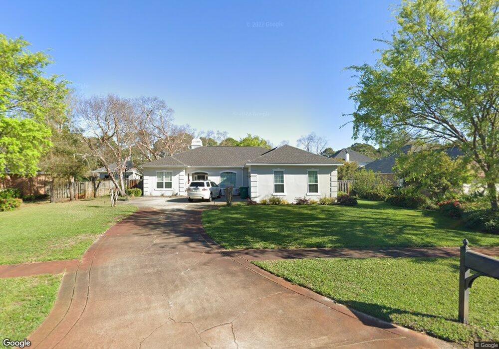
4071 Burning Tree Dr Destin, FL 32541
Estimated Value: $605,028 - $847,000
3
Beds
3
Baths
2,150
Sq Ft
$337/Sq Ft
Est. Value
About This Home
This home is located at 4071 Burning Tree Dr, Destin, FL 32541 and is currently estimated at $723,507, approximately $336 per square foot. 4071 Burning Tree Dr is a home located in Okaloosa County with nearby schools including Destin Elementary School, Destin Middle School, and Fort Walton Beach High School.
Ownership History
Date
Name
Owned For
Owner Type
Purchase Details
Closed on
Apr 29, 2011
Sold by
Mcneil Michael and Mcneil Catherine
Bought by
Thomas James L and Thomas Rebekah P
Current Estimated Value
Home Financials for this Owner
Home Financials are based on the most recent Mortgage that was taken out on this home.
Original Mortgage
$276,080
Interest Rate
4.74%
Mortgage Type
VA
Purchase Details
Closed on
Jul 31, 2006
Sold by
Atkins Anthony J and Atkins Traci G
Bought by
Mcneil Michael and Fash Catherine
Home Financials for this Owner
Home Financials are based on the most recent Mortgage that was taken out on this home.
Original Mortgage
$340,000
Interest Rate
6.37%
Mortgage Type
Purchase Money Mortgage
Purchase Details
Closed on
May 26, 2004
Sold by
Browne Robert A
Bought by
Atkins Anthony J and Atkins Traci G
Home Financials for this Owner
Home Financials are based on the most recent Mortgage that was taken out on this home.
Original Mortgage
$300,000
Interest Rate
5.37%
Mortgage Type
Purchase Money Mortgage
Create a Home Valuation Report for This Property
The Home Valuation Report is an in-depth analysis detailing your home's value as well as a comparison with similar homes in the area
Home Values in the Area
Average Home Value in this Area
Purchase History
| Date | Buyer | Sale Price | Title Company |
|---|---|---|---|
| Thomas James L | $290,000 | None Available | |
| Mcneil Michael | $425,000 | Southern Escrow & Title Llc | |
| Atkins Anthony J | $340,000 | American Land Title Inc |
Source: Public Records
Mortgage History
| Date | Status | Borrower | Loan Amount |
|---|---|---|---|
| Previous Owner | Thomas James L | $276,080 | |
| Previous Owner | Mcneil Michael | $340,000 | |
| Previous Owner | Atkins Anthony J | $300,000 |
Source: Public Records
Tax History
| Year | Tax Paid | Tax Assessment Tax Assessment Total Assessment is a certain percentage of the fair market value that is determined by local assessors to be the total taxable value of land and additions on the property. | Land | Improvement |
|---|---|---|---|---|
| 2025 | $2,857 | $280,234 | -- | -- |
| 2024 | $2,698 | $272,336 | -- | -- |
| 2023 | $2,698 | $264,404 | $0 | $0 |
| 2022 | $2,630 | $256,703 | $0 | $0 |
| 2021 | $2,623 | $249,226 | $0 | $0 |
| 2020 | $2,601 | $245,785 | $0 | $0 |
| 2019 | $2,568 | $240,259 | $0 | $0 |
| 2018 | $2,545 | $235,779 | $0 | $0 |
| 2017 | $2,529 | $230,929 | $0 | $0 |
| 2016 | $2,461 | $226,179 | $0 | $0 |
| 2015 | $2,495 | $224,607 | $0 | $0 |
| 2014 | $2,504 | $222,824 | $0 | $0 |
Source: Public Records
Map
Nearby Homes
- 4079 Burning Tree Dr
- 4049 Indian Bayou N
- 138 Country Club Dr W
- 4125 Indian Bayou N
- 346 Louise Cir
- 337 Louise Cir
- 142 Indian Bayou Dr
- 4009 Lauren Ct
- 121 Country Club Dr W
- 3956 Indian Trail
- 105 Indian Bayou Dr Unit 1
- 82 Indian Bayou Dr
- 4505 Olde Plantation Place
- 6 Country Club Dr E
- 12 Country Club Dr E
- 4500 Olde Plantation Place
- 237 Matties Way
- 3896 Mesa Rd
- 4043 Drifting Sand Trail
- 54 Country Club Dr E Unit 1
- 4075 Burning Tree Dr
- 4067 Burning Tree Dr
- 4070 Indian Trail
- 4066 Indian Trail
- 4074 Indian Trail
- 4072 Burning Tree Dr
- 4063 Burning Tree Dr
- 4062 Indian Trail
- 4078 Indian Trail
- 4068 Burning Tree Dr
- 4080 Burning Tree Dr
- 322 Fox Den Ct
- 4083 Burning Tree Dr
- 4059 Burning Tree Dr
- 4082 Indian Trail
- 4058 Burning Tree Dr
- 4084 Burning Tree Dr
- 320 Fox Den Ct
- 4054 Indian Trail
- 332 Deerfield Dr
Your Personal Tour Guide
Ask me questions while you tour the home.