
Estimated payment $2,010/month
Highlights
- Clubhouse
- Ranch Style House
- Community Pool
- Pond
- Sun or Florida Room
- Home Office
About This Home
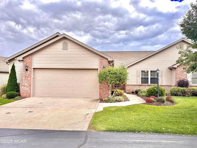
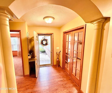
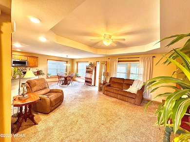
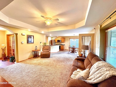
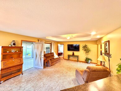
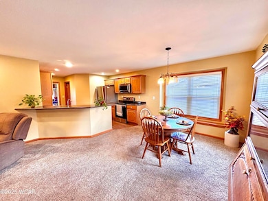
Welcome to carefree living at The Condos at Springbrook Greens! This beautiful condo was built in 2008 and offers modern comfort coupled with easy maintenance living. Step inside to discover a bright and inviting layout. This home offers 2 large bedrooms, both with walk in closets. The spacious living area flows seamlessly into a warm and welcoming three-season room that overlooks the pond and fountain. Perfect for morning coffee and relaxed evenings. Or step out onto the brand new composite rear deck to enjoy the view...weather resistant and virtually maintenance free. This home also includes a 2-plus-car garage and a full staircase to the attic from the garage giving you extra space for vehicles, storage or a workshop. In 2024, the HVAC system was upgraded to a brand-new furnace for peace of mind and efficient heating. HOA monthly dues of $225 cover landscaping and lawn maintenance, garbage, snow removal, exterior paint, and access to the private clubhouse and pool. This home is move-in ready, low maintenance, very well maintained, and designed for comfort, convenience and beautiful views.
Listing Agent
Merritt Real Estate Professionals License #2017006104 Listed on: 10/24/2025
Property Details
Home Type
- Condominium
Est. Annual Taxes
- $4,394
Year Built
- Built in 2008
HOA Fees
- $225 Monthly HOA Fees
Parking
- 2 Car Attached Garage
Home Design
- Ranch Style House
Interior Spaces
- 1,425 Sq Ft Home
- Combination Dining and Living Room
- Home Office
- Sun or Florida Room
- Crawl Space
Kitchen
- Range
- Microwave
- Dishwasher
- Disposal
Flooring
- Carpet
- Laminate
Bedrooms and Bathrooms
- 2 Bedrooms
- 2 Full Bathrooms
Laundry
- Dryer
- Washer
Outdoor Features
- Pond
Utilities
- Forced Air Heating and Cooling System
- Heating System Uses Natural Gas
- Gas Water Heater
Listing and Financial Details
- Assessor Parcel Number 37-0702-01-019.556
Community Details
Overview
- Springbrook Greens Community
Amenities
- Clubhouse
Recreation
- Community Pool
Map
Home Values in the Area
Average Home Value in this Area
Tax History
| Year | Tax Paid | Tax Assessment Tax Assessment Total Assessment is a certain percentage of the fair market value that is determined by local assessors to be the total taxable value of land and additions on the property. | Land | Improvement |
|---|---|---|---|---|
| 2024 | $4,394 | $101,050 | $14,630 | $86,420 |
| 2023 | $3,113 | $69,690 | $10,080 | $59,610 |
| 2022 | $3,144 | $69,690 | $10,080 | $59,610 |
| 2021 | $3,162 | $69,690 | $10,080 | $59,610 |
| 2020 | $2,483 | $49,910 | $10,080 | $39,830 |
| 2019 | $2,483 | $49,910 | $10,080 | $39,830 |
| 2018 | $2,422 | $49,910 | $10,080 | $39,830 |
| 2017 | $2,010 | $49,910 | $10,080 | $39,830 |
| 2016 | $1,982 | $49,910 | $10,080 | $39,830 |
| 2015 | $1,983 | $49,910 | $10,080 | $39,830 |
| 2014 | $2,009 | $48,860 | $9,590 | $39,270 |
| 2013 | $2,012 | $48,860 | $9,590 | $39,270 |
Property History
| Date | Event | Price | List to Sale | Price per Sq Ft |
|---|---|---|---|---|
| 11/04/2025 11/04/25 | Pending | -- | -- | -- |
| 10/24/2025 10/24/25 | For Sale | $269,900 | -- | $189 / Sq Ft |
Purchase History
| Date | Type | Sale Price | Title Company |
|---|---|---|---|
| Fiduciary Deed | $164,000 | None Available | |
| Warranty Deed | $165,000 | None Available |
Mortgage History
| Date | Status | Loan Amount | Loan Type |
|---|---|---|---|
| Previous Owner | $204,400 | Adjustable Rate Mortgage/ARM |
Source: West Central Association of REALTORS® (OH)
MLS Number: 308646
APN: 37-07-02-01-019.556
- 4050 Brookshore Dr
- 3270 Bonnieview Dr
- 3798 Kissing Hollow Dr
- 1129 W Bluelick Rd
- 0 Fraunfelter Unit 307817
- 0 N Eastown Rd Unit 1034495
- 3456 Shearin Ave
- 168 Lyre Bird Ln
- 1679 E Bluelick Rd
- 2718 Carolyn Dr
- 2630 Carolyn Dr
- 2371 Mandolin Dr
- 105 Watt Ave
- 1743 Sherry Lee Dr
- 1619 Northbrook Dr
- 2511 Debbie Dr
- 2104 Virginia Ave
- 700 Lewis Blvd
- 410 W Northern Ave
- 400 W Northern Ave
