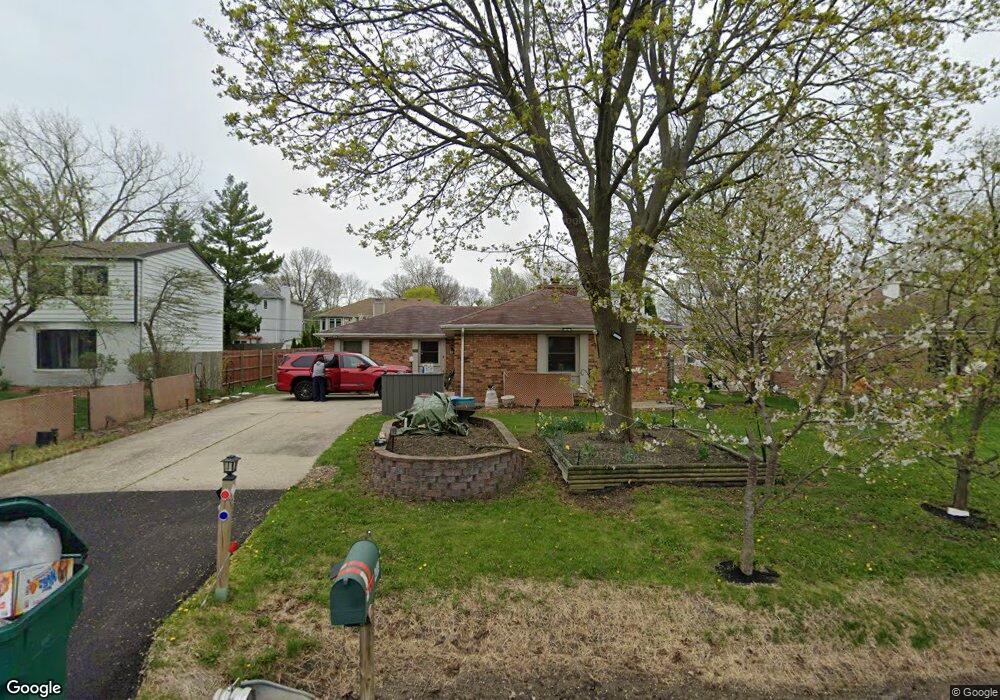
4083 Harper Ave Gurnee, IL 60031
Estimated Value: $327,034 - $390,000
3
Beds
2
Baths
1,694
Sq Ft
$214/Sq Ft
Est. Value
About This Home
This home is located at 4083 Harper Ave, Gurnee, IL 60031 and is currently estimated at $363,259, approximately $214 per square foot. 4083 Harper Ave is a home located in Lake County with nearby schools including Spaulding Elementary School, Viking Middle School, and Warren Township High School.
Ownership History
Date
Name
Owned For
Owner Type
Purchase Details
Closed on
Sep 16, 2006
Sold by
Zwerling Michelle
Bought by
Zwerling Michelle A and Michelle A Zwerling Trust
Current Estimated Value
Purchase Details
Closed on
Jul 29, 2005
Sold by
Tekeli Sait and Tekeli Living Trust
Bought by
Zwerling Michelle
Purchase Details
Closed on
Nov 16, 1998
Sold by
Tekeli Sait and Tekeli Ayse Nazan
Bought by
Tekeli Sait and Tekeli Ayse Nazan
Create a Home Valuation Report for This Property
The Home Valuation Report is an in-depth analysis detailing your home's value as well as a comparison with similar homes in the area
Home Values in the Area
Average Home Value in this Area
Purchase History
| Date | Buyer | Sale Price | Title Company |
|---|---|---|---|
| Zwerling Michelle A | -- | None Available | |
| Zwerling Michelle | $275,000 | First American Title | |
| Tekeli Sait | -- | -- |
Source: Public Records
Tax History Compared to Growth
Tax History
| Year | Tax Paid | Tax Assessment Tax Assessment Total Assessment is a certain percentage of the fair market value that is determined by local assessors to be the total taxable value of land and additions on the property. | Land | Improvement |
|---|---|---|---|---|
| 2024 | $8,019 | $98,522 | $10,692 | $87,830 |
| 2023 | $7,483 | $87,065 | $9,449 | $77,616 |
| 2022 | $7,483 | $80,460 | $9,911 | $70,549 |
| 2021 | $6,448 | $73,553 | $9,060 | $64,493 |
| 2020 | $6,248 | $71,745 | $8,837 | $62,908 |
| 2019 | $6,091 | $69,662 | $8,580 | $61,082 |
| 2018 | $5,824 | $66,262 | $8,294 | $57,968 |
| 2017 | $5,762 | $64,363 | $8,056 | $56,307 |
| 2016 | $5,588 | $61,497 | $7,697 | $53,800 |
| 2015 | $5,426 | $58,324 | $7,300 | $51,024 |
| 2014 | $6,259 | $68,406 | $7,607 | $60,799 |
| 2012 | $7,162 | $68,930 | $7,665 | $61,265 |
Source: Public Records
Map
Nearby Homes
- 4074 Blackstone Ave
- 4176 Blackstone Ave
- 287 Jennifer Ct Unit 12
- 3951 Blackstone Ave
- 3947 Blackstone Ave
- 93 Berkshire Ct Unit D
- 4471 Brighton Ct Unit 7
- 287 Kensington Ct Unit 4
- 4124 Russell Ave
- 389 Pine Grove Ave
- 578 Pine Grove Ave
- 424 Greenview Dr
- 450 Tanglewood Dr
- 468 Tanglewood Dr
- 00 Northwood Ave
- 0 Northwoods Ave Unit MRD11938775
- 964 Magnolia Ave
- 33564 Greenleaf St
- 334 Concord Square
- 951 Belle Plaine Ave
- 4067 Harper Ave
- 335 N Delany Rd
- 4086 Blackstone Ave
- 4055 Harper Ave
- 4062 Blackstone Ave
- 4080 Harper Ave
- 4070 Harper Ave
- 4090 Harper Ave
- 336 N Delany Rd
- 4050 Blackstone Ave
- 4060 Harper Ave
- 4035 Harper Ave
- 4110 Blackstone Ave
- 4125 Harper Ave
- 4040 Harper Ave
- 4038 Blackstone Ave
- 4095 Blackstone Ave
- 4112 Harper Ave
- 260 Suda Dr Unit 3
- 4079 Kenwood Ave