Estimated Value: $252,000 - $296,000
3
Beds
2
Baths
2,500
Sq Ft
$112/Sq Ft
Est. Value
About This Home
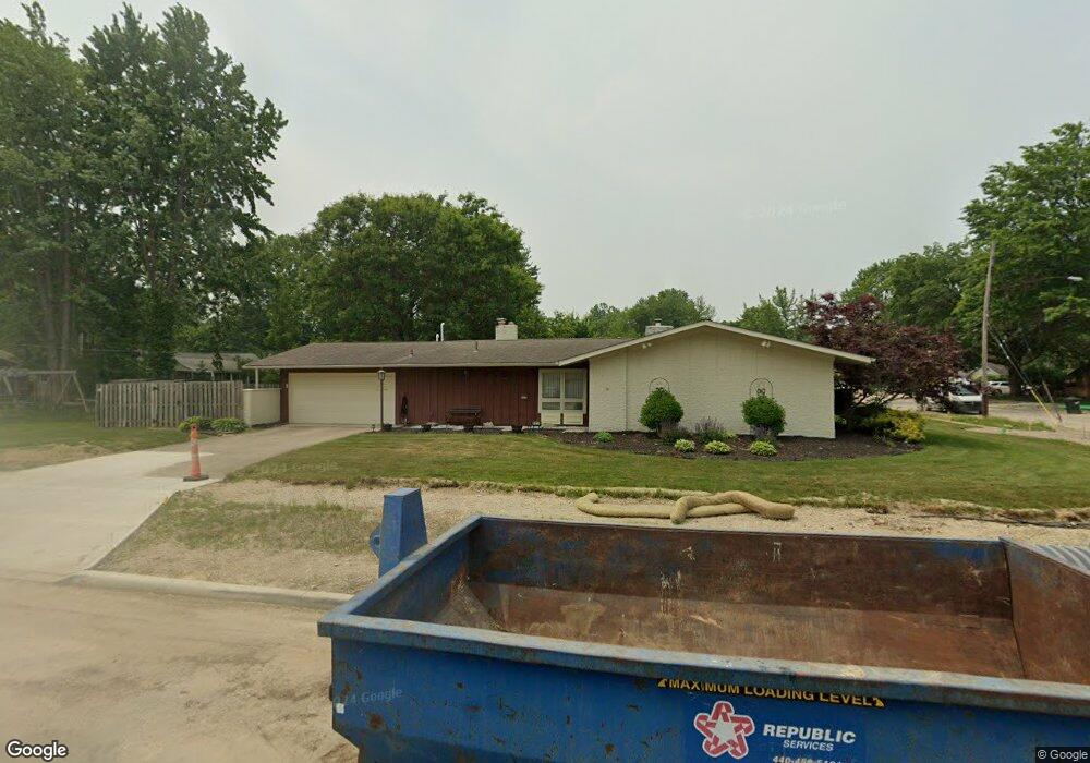
This home is located at 409 Maple Ave, Berea, OH 44017 and is currently estimated at $280,391, approximately $112 per square foot. 409 Maple Ave is a home located in Cuyahoga County with nearby schools including Grindstone Elementary School, Berea-Midpark Middle School, and Berea-Midpark High School.
Ownership History
Date
Name
Owned For
Owner Type
Purchase Details
Closed on
Mar 22, 2022
Sold by
Mcintyre Jr Ledell S and Mcintyre Justine
Bought by
Mcintyre Family Revocable Living Trust
Current Estimated Value
Purchase Details
Closed on
Oct 8, 2010
Sold by
Eldridge Wayne E
Bought by
Mcintyre Ledell S and Lance Mcintyre Justine
Home Financials for this Owner
Home Financials are based on the most recent Mortgage that was taken out on this home.
Original Mortgage
$125,600
Interest Rate
4.26%
Mortgage Type
Purchase Money Mortgage
Purchase Details
Closed on
May 2, 2007
Sold by
Eldridge Dorothy D
Bought by
Eldridge Dorothy D
Purchase Details
Closed on
Nov 22, 2005
Sold by
Estate Of Wayne E Eldridge
Bought by
Eldridge Dorothy D
Purchase Details
Closed on
Jan 1, 1975
Bought by
Eldridge Wayne E and Eldridge Dorothy D
Create a Home Valuation Report for This Property
The Home Valuation Report is an in-depth analysis detailing your home's value as well as a comparison with similar homes in the area
Home Values in the Area
Average Home Value in this Area
Purchase History
| Date | Buyer | Sale Price | Title Company |
|---|---|---|---|
| Mcintyre Family Revocable Living Trust | -- | Karl Margaret T | |
| Mcintyre Ledell S | $157,000 | Revere Title | |
| Eldridge Dorothy D | -- | Attorney | |
| Eldridge Dorothy D | -- | Attorney | |
| Eldridge Wayne E | -- | -- |
Source: Public Records
Mortgage History
| Date | Status | Borrower | Loan Amount |
|---|---|---|---|
| Previous Owner | Mcintyre Ledell S | $125,600 |
Source: Public Records
Tax History
| Year | Tax Paid | Tax Assessment Tax Assessment Total Assessment is a certain percentage of the fair market value that is determined by local assessors to be the total taxable value of land and additions on the property. | Land | Improvement |
|---|---|---|---|---|
| 2024 | $4,730 | $79,835 | $16,660 | $63,175 |
| 2023 | $4,634 | $65,630 | $12,080 | $53,550 |
| 2022 | $4,605 | $65,630 | $12,080 | $53,550 |
| 2021 | $4,569 | $65,630 | $12,080 | $53,550 |
| 2020 | $4,365 | $55,620 | $10,220 | $45,400 |
| 2019 | $4,252 | $158,900 | $29,200 | $129,700 |
| 2018 | $4,134 | $55,620 | $10,220 | $45,400 |
| 2017 | $4,322 | $52,750 | $8,790 | $43,960 |
| 2016 | $4,291 | $52,750 | $8,790 | $43,960 |
| 2015 | $4,231 | $52,750 | $8,790 | $43,960 |
| 2014 | $4,231 | $54,960 | $9,140 | $45,820 |
Source: Public Records
Map
Nearby Homes
- 56 3rd Ave
- 20415 Brookstone Trail
- 0 E Bagley Rd Unit 5111166
- 41 W 5th Ave
- 93 W 5th Ave
- 445 Berea St
- 725 Shakespeare Dr
- 57 Riverside Dr
- 487 Karen Dr
- 211 W Bridge St
- 47 Prospect St
- 6574 Burton Dr
- 209 Gibson St
- 146 Marian Ln
- 160 Marian Ln Unit 6A
- 49 Monroe St
- 216 Kraft St
- 275 Quarrystone Ln
- 428 Park Place
- 379 Laurel Dr
Your Personal Tour Guide
Ask me questions while you tour the home.