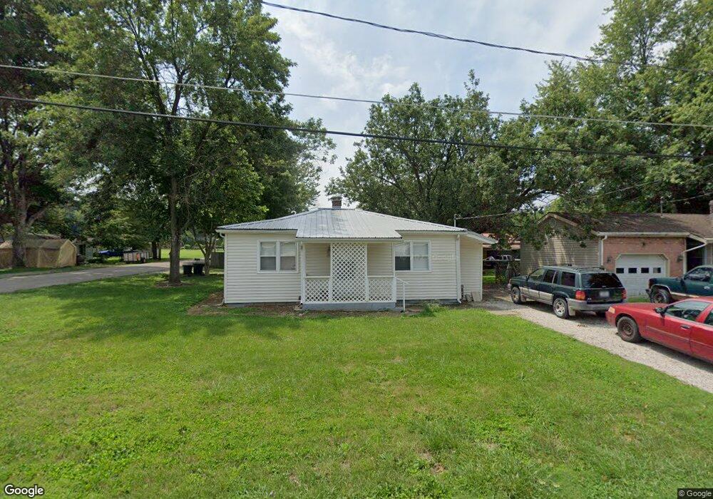
409 Taylor Ave New Harmony, IN 47631
Estimated Value: $115,000 - $127,000
2
Beds
1
Bath
750
Sq Ft
$162/Sq Ft
Est. Value
About This Home
This home is located at 409 Taylor Ave, New Harmony, IN 47631 and is currently estimated at $121,319, approximately $161 per square foot. 409 Taylor Ave is a home located in Posey County with nearby schools including North Posey Junior High School and North Posey Senior High School.
Ownership History
Date
Name
Owned For
Owner Type
Purchase Details
Closed on
Aug 14, 2015
Sold by
21St Mortgage Corporation
Bought by
Mathews John W
Current Estimated Value
Purchase Details
Closed on
Oct 19, 2006
Sold by
Jackson Gene
Bought by
Davis Donna J and Davis Jerry E
Home Financials for this Owner
Home Financials are based on the most recent Mortgage that was taken out on this home.
Original Mortgage
$61,200
Interest Rate
9.45%
Mortgage Type
Adjustable Rate Mortgage/ARM
Create a Home Valuation Report for This Property
The Home Valuation Report is an in-depth analysis detailing your home's value as well as a comparison with similar homes in the area
Purchase History
| Date | Buyer | Sale Price | Title Company |
|---|---|---|---|
| Mathews John W | $7,000 | Meridian National Title | |
| Davis Donna J | -- | Homequest Title Llc |
Source: Public Records
Mortgage History
| Date | Status | Borrower | Loan Amount |
|---|---|---|---|
| Previous Owner | Davis Donna J | $61,200 |
Source: Public Records
Tax History
| Year | Tax Paid | Tax Assessment Tax Assessment Total Assessment is a certain percentage of the fair market value that is determined by local assessors to be the total taxable value of land and additions on the property. | Land | Improvement |
|---|---|---|---|---|
| 2024 | $567 | $87,200 | $14,600 | $72,600 |
| 2023 | $366 | $67,100 | $7,800 | $59,300 |
| 2022 | $383 | $63,000 | $7,800 | $55,200 |
| 2021 | $341 | $54,000 | $8,200 | $45,800 |
| 2020 | $316 | $52,300 | $8,000 | $44,300 |
| 2019 | $1,102 | $55,100 | $9,300 | $45,800 |
| 2018 | $1,060 | $53,000 | $9,300 | $43,700 |
| 2017 | $1,020 | $51,000 | $9,300 | $41,700 |
| 2016 | $1,020 | $51,000 | $9,300 | $41,700 |
| 2014 | $196 | $52,300 | $9,300 | $43,000 |
| 2013 | $196 | $52,700 | $9,300 | $43,400 |
Source: Public Records
Map
Nearby Homes
- 627 Frederick St
- 303 Church St
- 403 East St
- 404 East St
- 620 Granary St
- 226 Freeman Ln
- 1823 Indiana 68
- 336 Co Rd 1980e
- 10006 Bethsaida Church Rd
- 518 Turner Rd
- 5100 Haines Rd
- 1972 Cr 1985 N
- 304 W Rudolph St
- 505 Fourth St
- 0 S 1850 Rd W Unit 202431574
- 7340 Indiana 66
- 21 N Walker St
- 32 W Fletchall St
- 318 N Church St
- 624 Warren St
- 1109 Lynnwood Ave
- 403 Taylor Ave
- 1111 Lynnwood Ave
- 1013 Lynnwood Ave
- 1114 Lynnwood Ave
- 1119 Lynnwood Ave
- 500 Taylor Ave
- 1112 Lynnwood Ave
- 331 Taylor Ave
- 338 Wood Ave
- 1112 Locust St
- 1003 Lynnwood Ave
- 1103 Main St
- 1015 Main St
- 1111 Main St
- 1117 Main St
- 1107 Locust St
- 1009 Locust St
- 11115 Locust St
- 1013 Locust St
Your Personal Tour Guide
Ask me questions while you tour the home.