
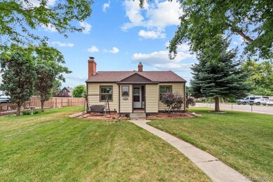
4095 Quay St Wheat Ridge, CO 80033
Barths NeighborhoodEstimated payment $3,708/month
Highlights
- Wood Burning Stove
- Wood Flooring
- Bonus Room
- Traditional Architecture
- 2 Fireplaces
- Corner Lot
About This Home
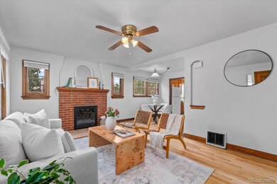
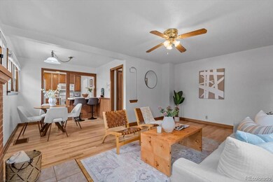
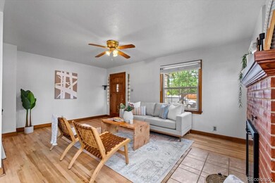
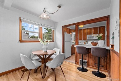
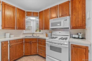
MAJOR PRICE REDUCTION! Welcome to this delightful 3-bedroom, 2-bathroom ranch-style home nestled on a large, beautifully landscaped corner lot in desirable Wheat Ridge surrounded by amazing neighbors. These are truly the people you want to live near! With over 2,000 square feet of living space, this home blends original character with thoughtful updates and versatile features. Step inside to discover timeless charm with original woodwork, classic door knobs, and hardware that reflect the home’s heritage. The main-floor bathroom has been tastefully updated, while the cozy kitchen exudes vintage charm and functionality. A bright and expansive sunroom connects the main house to the garage, offering additional living space and housing the convenient main-level laundry. Downstairs, you’ll find a finished basement with a non-conforming bedroom, a spacious living area, a wet bar, and a stunningly updated bathroom featuring beautiful tilework and a walk-in shower. There’s also plenty of storage to keep things organized. Car enthusiasts and hobbyists will fall in love with the oversized two-car garage, complete with heating, swamp cooling, its own furnace, built-in workbenches, a band saw, and a large standing safe. The extra-wide driveway provides plenty of room for guests, and the fully enclosed side yard is perfect for storing your boat, RV, or other vehicles behind a secure gate. Enjoy Colorado evenings in the private backyard under the pergola, grilling with the included gas grill or tending to the raised garden beds. A spacious 12’x15’ shed offers even more storage for tools or toys. This unique property combines space, functionality, and vintage appeal—don’t miss your chance to make it yours!
Listing Agent
RE/MAX Momentum Brokerage Phone: 720-434-7375 License #100084942 Listed on: 07/17/2025

Home Details
Home Type
- Single Family
Est. Annual Taxes
- $3,458
Year Built
- Built in 1945
Lot Details
- 0.27 Acre Lot
- Partially Fenced Property
- Corner Lot
- Front and Back Yard Sprinklers
- Private Yard
Parking
- 2 Car Attached Garage
- Oversized Parking
- Heated Garage
- Lighted Parking
- Exterior Access Door
- 2 RV Parking Spaces
Home Design
- Traditional Architecture
- Frame Construction
- Composition Roof
Interior Spaces
- 1-Story Property
- 2 Fireplaces
- Wood Burning Stove
- Family Room
- Living Room
- Dining Room
- Bonus Room
- Utility Room
- Oven
Flooring
- Wood
- Carpet
- Tile
Bedrooms and Bathrooms
- 3 Bedrooms | 2 Main Level Bedrooms
Laundry
- Laundry Room
- Dryer
- Washer
Finished Basement
- Basement Fills Entire Space Under The House
- 1 Bedroom in Basement
Home Security
- Carbon Monoxide Detectors
- Fire and Smoke Detector
Outdoor Features
- Exterior Lighting
- Rain Gutters
Location
- Ground Level
Schools
- Stevens Elementary School
- Everitt Middle School
- Wheat Ridge High School
Utilities
- Mini Split Air Conditioners
- Forced Air Heating System
- 220 Volts
- 220 Volts in Garage
- 110 Volts
Community Details
- No Home Owners Association
- Upland Acres Subdivision
Listing and Financial Details
- Exclusions: Staging Items
- Assessor Parcel Number 024346
Map
Home Values in the Area
Average Home Value in this Area
Tax History
| Year | Tax Paid | Tax Assessment Tax Assessment Total Assessment is a certain percentage of the fair market value that is determined by local assessors to be the total taxable value of land and additions on the property. | Land | Improvement |
|---|---|---|---|---|
| 2024 | $3,448 | $39,430 | $17,495 | $21,935 |
| 2023 | $3,448 | $39,430 | $17,495 | $21,935 |
| 2022 | $2,283 | $32,592 | $17,328 | $15,264 |
| 2021 | $2,315 | $33,530 | $17,827 | $15,703 |
| 2020 | $2,030 | $30,403 | $15,804 | $14,599 |
| 2019 | $2,003 | $30,403 | $15,804 | $14,599 |
| 2018 | $2,406 | $26,998 | $10,481 | $16,517 |
| 2017 | $2,172 | $26,998 | $10,481 | $16,517 |
| 2016 | $1,947 | $22,638 | $6,280 | $16,358 |
| 2015 | $1,675 | $22,638 | $6,280 | $16,358 |
| 2014 | $1,675 | $18,276 | $5,731 | $12,545 |
Property History
| Date | Event | Price | List to Sale | Price per Sq Ft |
|---|---|---|---|---|
| 11/13/2025 11/13/25 | Price Changed | $650,000 | -5.1% | $321 / Sq Ft |
| 09/23/2025 09/23/25 | Price Changed | $685,000 | -2.1% | $338 / Sq Ft |
| 09/11/2025 09/11/25 | Price Changed | $699,900 | -1.4% | $345 / Sq Ft |
| 09/04/2025 09/04/25 | Price Changed | $710,000 | -1.4% | $350 / Sq Ft |
| 08/29/2025 08/29/25 | Price Changed | $720,000 | -0.4% | $355 / Sq Ft |
| 08/29/2025 08/29/25 | Price Changed | $723,000 | -0.3% | $357 / Sq Ft |
| 08/11/2025 08/11/25 | For Sale | $725,000 | 0.0% | $358 / Sq Ft |
| 08/06/2025 08/06/25 | Pending | -- | -- | -- |
| 07/17/2025 07/17/25 | For Sale | $725,000 | -- | $358 / Sq Ft |
Purchase History
| Date | Type | Sale Price | Title Company |
|---|---|---|---|
| Deed Of Distribution | -- | None Listed On Document | |
| Personal Reps Deed | $112,000 | Stewart Title |
Mortgage History
| Date | Status | Loan Amount | Loan Type |
|---|---|---|---|
| Previous Owner | $89,600 | No Value Available | |
| Closed | $16,800 | No Value Available |
Source: REcolorado®
MLS Number: 1518192
APN: 39-234-10-018
Disclaimer: Certain information contained herein is derived from information provided by parties other than Homes.com. All information provided is deemed reliable, but is not guaranteed to be accurate and should be independently verified.
![]() The content relating to real estate for sale in this Web site comes in part from the Internet Data eXchange (“IDX”) program of METROLIST, INC., DBA RECOLORADO®. Real estate listings held by brokers other than Ten-X are marked with the IDX Logo. This information is being provided for the consumers’ personal, non-commercial use and may not be used for any other purpose. All information subject to change and should be independently verified.
The content relating to real estate for sale in this Web site comes in part from the Internet Data eXchange (“IDX”) program of METROLIST, INC., DBA RECOLORADO®. Real estate listings held by brokers other than Ten-X are marked with the IDX Logo. This information is being provided for the consumers’ personal, non-commercial use and may not be used for any other purpose. All information subject to change and should be independently verified.
This publication is designed to provide information with regard to the subject matter covered. It is displayed with the understanding that the publisher and authors are not engaged in rendering real estate, legal, accounting, tax, or other professional services and that the publisher and authors are not offering such advice in this publication. If real estate, legal, or other expert assistance is required, the services of a competent, professional person should be sought.
The information contained in this publication is subject to change without notice. METROLIST, INC., DBA RECOLORADO MAKES NO WARRANTY OF ANY KIND WITH REGARD TO THIS MATERIAL, INCLUDING, BUT NOT LIMITED TO, THE IMPLIED WARRANTIES OF MERCHANTABILITY AND FITNESS FOR A PARTICULAR PURPOSE. METROLIST, INC., DBA RECOLORADO SHALL NOT BE LIABLE FOR ERRORS CONTAINED HEREIN OR FOR ANY DAMAGES IN CONNECTION WITH THE FURNISHING, PERFORMANCE, OR USE OF THIS MATERIAL.
PUBLISHER’S NOTICE: All real estate advertised herein is subject to the Federal Fair Housing Act and the Colorado Fair Housing Act, which Acts make it illegal to make or publish any advertisement that indicates any preference, limitation, or discrimination based on race, color, religion, sex, handicap, familial status, or national origin.
METROLIST, INC., DBA RECOLORADO will not knowingly accept any advertising for real estate that is in violation of the law. All persons are hereby informed that all dwellings advertised are available on an equal opportunity basis.
© 2025 METROLIST, INC., DBA RECOLORADO® – All Rights Reserved. 6455 S. Yosemite St., Suite 500 Greenwood Village, CO 80111 USA
ALL RIGHTS RESERVED WORLDWIDE. No part of this publication may be reproduced, adapted, translated, stored in a retrieval system or transmitted in any form or by any means, electronic, mechanical, photocopying, recording, or otherwise, without the prior written permission of the publisher. The information contained herein including but not limited to all text, photographs, digital images, virtual tours, may be seeded and monitored for protection and tracking.
- 4125 Pierce St
- 4014 Upham St
- 4026 Upham St
- 4008 Upham St
- 3830 Pierce St
- 4024 Upham St
- 3820 Pierce St
- 3830 Otis St Unit 1-4
- 7010 W 44th Ave
- 6735 W 37th Place
- 4420 Teller St
- 6455 W 38th Ave
- 3728 Vance St Unit 1-4
- 4541 Reed St
- 3535 High Ct
- 3500 Otis St
- 4155 Ingalls St
- 6145 W 38th Ave
- 7801 W 39th Ave
- 4295 Harlan St
- 4105 Pierce St
- 7178 W 38th Ave Unit ID1285781P
- 7333 W 38th Ave
- 3748 Vance St
- 3650 Vance St
- 4603 Otis St
- 4603 Otis St
- 4217 Yarrow St
- 3501 Wadsworth Blvd
- 4585 Yukon Ct
- 7001 W 48th Ave
- 3266 Jay St Unit Basement 2 Bed 1 Bath
- 4750 Ingalls St
- 3195 Fenton St
- 3648 Ames St
- 3475 Ames St Unit C
- 4195 Zenobia St
- 3816 Zenobia St
- 3251 Sheridan Blvd Unit 3251 Sheridan Blvd
- 6201 W 26th Ave