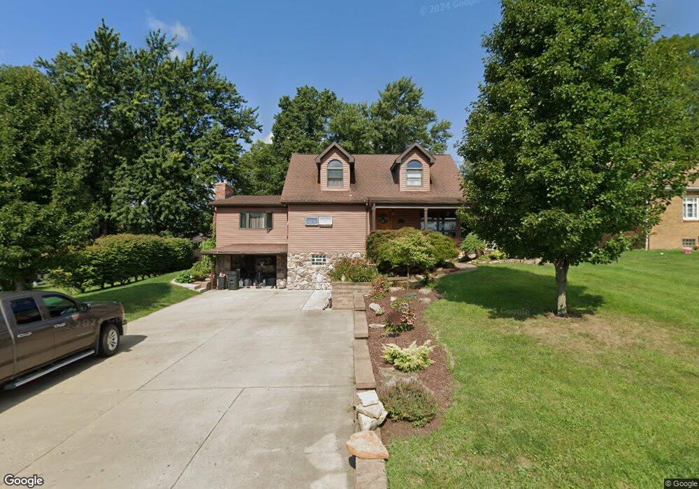
41 Anchor Dr Washington, PA 15301
Estimated Value: $215,000 - $268,000
3
Beds
2
Baths
1,350
Sq Ft
$185/Sq Ft
Est. Value
About This Home
This home is located at 41 Anchor Dr, Washington, PA 15301 and is currently estimated at $250,368, approximately $185 per square foot. 41 Anchor Dr is a home located in Washington County with nearby schools including Trinity Senior High School, John F Kennedy Catholic School, and Faith Christian School.
Ownership History
Date
Name
Owned For
Owner Type
Purchase Details
Closed on
Jan 20, 2016
Sold by
Thompson Kimberly A and Thompson Michael L
Bought by
Odonohoe Matthew and Odonohoe Leann
Current Estimated Value
Home Financials for this Owner
Home Financials are based on the most recent Mortgage that was taken out on this home.
Original Mortgage
$126,475
Outstanding Balance
$99,891
Interest Rate
3.75%
Mortgage Type
FHA
Estimated Equity
$150,477
Purchase Details
Closed on
Dec 3, 2010
Sold by
Romano Sheriff Samuel F and Simonelli Chad M
Bought by
Beneficial Consumer Disc Co
Create a Home Valuation Report for This Property
The Home Valuation Report is an in-depth analysis detailing your home's value as well as a comparison with similar homes in the area
Home Values in the Area
Average Home Value in this Area
Purchase History
| Date | Buyer | Sale Price | Title Company |
|---|---|---|---|
| Odonohoe Matthew | $150,000 | None Available | |
| Beneficial Consumer Disc Co | -- | -- |
Source: Public Records
Mortgage History
| Date | Status | Borrower | Loan Amount |
|---|---|---|---|
| Open | Odonohoe Matthew | $126,475 |
Source: Public Records
Tax History Compared to Growth
Tax History
| Year | Tax Paid | Tax Assessment Tax Assessment Total Assessment is a certain percentage of the fair market value that is determined by local assessors to be the total taxable value of land and additions on the property. | Land | Improvement |
|---|---|---|---|---|
| 2025 | $2,631 | $148,200 | $48,600 | $99,600 |
| 2024 | $2,349 | $148,200 | $48,600 | $99,600 |
| 2023 | $2,349 | $148,200 | $48,600 | $99,600 |
| 2022 | $2,275 | $148,200 | $48,600 | $99,600 |
| 2021 | $2,213 | $148,200 | $48,600 | $99,600 |
| 2020 | $2,158 | $148,200 | $48,600 | $99,600 |
| 2019 | $2,122 | $148,200 | $48,600 | $99,600 |
| 2018 | $2,097 | $148,200 | $48,600 | $99,600 |
| 2017 | $278 | $148,200 | $48,600 | $99,600 |
| 2016 | $278 | $11,179 | $538 | $10,641 |
| 2015 | -- | $11,179 | $538 | $10,641 |
| 2014 | $278 | $11,179 | $538 | $10,641 |
| 2013 | $278 | $11,179 | $538 | $10,641 |
Source: Public Records
Map
Nearby Homes
- 1027 Locust Ave
- 40 Stone Marker Dr
- 183 Country Club Rd
- 120 John St
- 300 Sunset Blvd
- 555 Fairway St
- 1296 N Main St
- 1166 N Main St
- 114 Black Oak Ln
- 79 Pine Valley Rd
- 1445 N Main St
- 16 Panorama Dr
- 1721 Donnan Ave
- 19 Murtland Ave
- 165 E Katherine Ave
- 40 Laurel Ave
- 831 N Main St
- 395 Burton Ave
- 640 N Wade Ave
- 675 E Beau St