
Seller's Agent in 2025
Jennifer Karpius
William Raveis Real Estate
(914) 625-7013
1 in this area
16 Total Sales
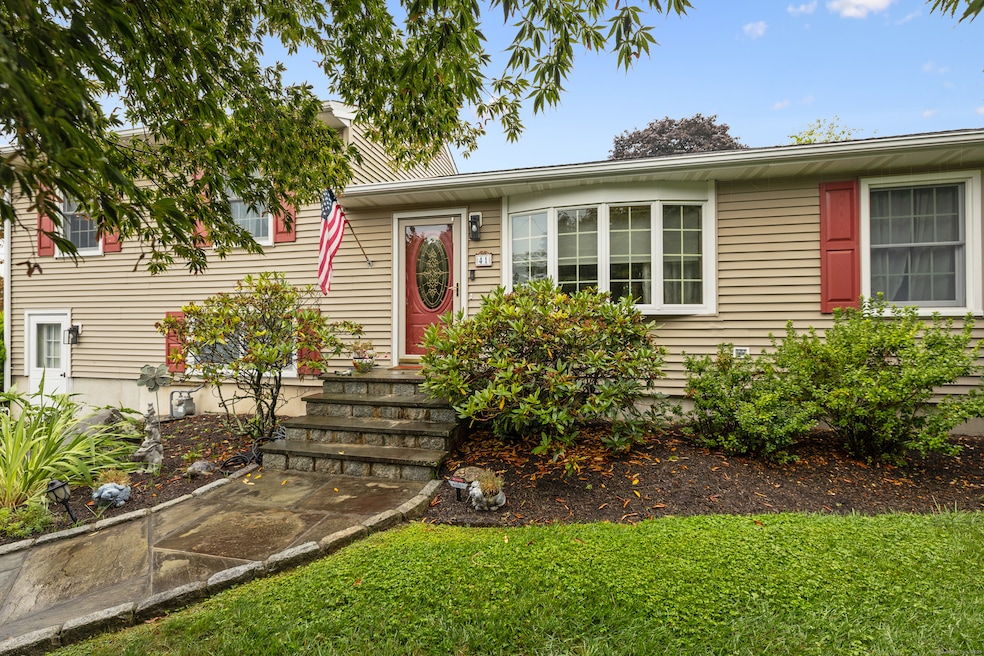
Beautifully maintained 4-bedroom, 2.5-bath home in Stamford's desirable Cove neighborhood, just minutes from Cove Beach. The upper level features three bedrooms with a full bath, along with a primary bedroom offering a private en-suite and two double closets. Hardwood floors throughout, and a spacious family room with a dining area boasting a vaulted ceiling that opens to the back deck and fenced-in yard-perfect for entertaining. The updated kitchen features newer appliances and Corian countertops. A finished basement offers a bonus living space, laundry, and a half bath, while the converted garage can serve as a gym and kitchenette, ideal for an in-law suite. Situated on a corner lot, the property offers two driveways with parking for at least five cars. Highest & Best by Wednesday 9/17 5PM. Please submit all offers on standard form.
Last Agent to Sell the Property
William Raveis Real Estate Brokerage Phone: (914) 625-7013 License #RES.0807590 Listed on: 09/08/2025
| Date | Type | Sale Price | Title Company |
|---|---|---|---|
| Warranty Deed | $926,500 | -- | |
| Quit Claim Deed | -- | None Available | |
| Quit Claim Deed | -- | None Available | |
| Quit Claim Deed | -- | None Available | |
| Warranty Deed | $30,000 | -- | |
| Warranty Deed | $30,000 | -- |
| Date | Status | Loan Amount | Loan Type |
|---|---|---|---|
| Previous Owner | $247,800 | New Conventional | |
| Previous Owner | $324,150 | No Value Available | |
| Previous Owner | $353,700 | No Value Available |
| Date | Event | Price | List to Sale | Price per Sq Ft |
|---|---|---|---|---|
| 11/06/2025 11/06/25 | Sold | $926,500 | +5.9% | $367 / Sq Ft |
| 10/04/2025 10/04/25 | Pending | -- | -- | -- |
| 09/08/2025 09/08/25 | For Sale | $875,000 | -- | $346 / Sq Ft |
| Year | Tax Paid | Tax Assessment Tax Assessment Total Assessment is a certain percentage of the fair market value that is determined by local assessors to be the total taxable value of land and additions on the property. | Land | Improvement |
|---|---|---|---|---|
| 2025 | $11,427 | $477,720 | $229,920 | $247,800 |
| 2024 | $11,160 | $477,720 | $229,920 | $247,800 |
| 2023 | $12,058 | $477,720 | $229,920 | $247,800 |
| 2022 | $11,247 | $413,940 | $166,630 | $247,310 |
| 2021 | $11,152 | $413,940 | $166,630 | $247,310 |
| 2020 | $10,907 | $413,940 | $166,630 | $247,310 |
| 2019 | $10,907 | $413,940 | $166,630 | $247,310 |
| 2018 | $10,568 | $413,940 | $166,630 | $247,310 |
| 2017 | $9,938 | $369,580 | $136,590 | $232,990 |
| 2016 | $9,653 | $369,580 | $136,590 | $232,990 |
| 2015 | $9,398 | $369,580 | $136,590 | $232,990 |
| 2014 | $9,162 | $369,580 | $136,590 | $232,990 |
Seller's Agent in 2025
Jennifer Karpius
William Raveis Real Estate
(914) 625-7013
1 in this area
16 Total Sales
Buyer's Agent in 2025
Patricia Palumbo
Coldwell Banker Realty
(917) 673-0830
1 in this area
21 Total Sales
Source: SmartMLS
MLS Number: 24123083
APN: STAM-000000-000000-005481
Disclaimer: Certain information contained herein is derived from information provided by parties other than Homes.com. All information provided is deemed reliable, but is not guaranteed to be accurate and should be independently verified.
![]() IDX information is provided exclusively for personal, non-commercial use, and may not be used for any purpose other than to identify prospective properties consumers may be interested in purchasing. Information is deemed reliable but not guaranteed.
IDX information is provided exclusively for personal, non-commercial use, and may not be used for any purpose other than to identify prospective properties consumers may be interested in purchasing. Information is deemed reliable but not guaranteed.
Ask me questions while you tour the home.