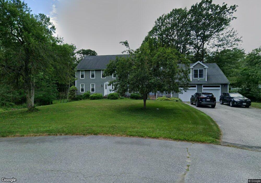
41 Bayberry Rd Dracut, MA 01826
Estimated Value: $882,564 - $1,025,000
5
Beds
4
Baths
3,568
Sq Ft
$262/Sq Ft
Est. Value
About This Home
This home is located at 41 Bayberry Rd, Dracut, MA 01826 and is currently estimated at $934,141, approximately $261 per square foot. 41 Bayberry Rd is a home located in Middlesex County with nearby schools including Joseph A. Campbell Elementary School, Richardson Middle School, and Dracut Senior High School.
Ownership History
Date
Name
Owned For
Owner Type
Purchase Details
Closed on
Jun 15, 2015
Sold by
Decorpo Paul M and Decorpo Mary J
Bought by
Decorpo T
Current Estimated Value
Purchase Details
Closed on
Jan 31, 1990
Sold by
Draco Homes Inc
Bought by
Corpo Paul
Create a Home Valuation Report for This Property
The Home Valuation Report is an in-depth analysis detailing your home's value as well as a comparison with similar homes in the area
Home Values in the Area
Average Home Value in this Area
Purchase History
| Date | Buyer | Sale Price | Title Company |
|---|---|---|---|
| Decorpo T | -- | -- | |
| Corpo Paul | $244,825 | -- |
Source: Public Records
Mortgage History
| Date | Status | Borrower | Loan Amount |
|---|---|---|---|
| Previous Owner | Corpo Paul | $100,000 | |
| Previous Owner | Corpo Paul | $100,000 | |
| Previous Owner | Corpo Paul | $120,000 |
Source: Public Records
Tax History
| Year | Tax Paid | Tax Assessment Tax Assessment Total Assessment is a certain percentage of the fair market value that is determined by local assessors to be the total taxable value of land and additions on the property. | Land | Improvement |
|---|---|---|---|---|
| 2025 | $8,687 | $858,400 | $251,600 | $606,800 |
| 2024 | $8,467 | $810,200 | $239,700 | $570,500 |
| 2023 | $8,208 | $708,800 | $208,500 | $500,300 |
| 2022 | $8,297 | $675,100 | $189,600 | $485,500 |
| 2021 | $8,008 | $615,500 | $172,200 | $443,300 |
| 2020 | $7,714 | $577,800 | $167,000 | $410,800 |
| 2019 | $7,344 | $534,100 | $159,000 | $375,100 |
| 2018 | $7,323 | $517,900 | $159,000 | $358,900 |
| 2017 | $7,341 | $517,900 | $159,000 | $358,900 |
| 2016 | $7,230 | $487,200 | $159,800 | $327,400 |
| 2015 | $6,928 | $464,000 | $159,800 | $304,200 |
| 2014 | $6,434 | $444,000 | $159,800 | $284,200 |
Source: Public Records
Map
Nearby Homes
- 277 Loon Hill Rd
- 31 Varnum Ave
- 10 Lanseigne St
- 89 Newbury St
- 14 Mount Pleasant Ave
- 821 Merrimack Ave
- 4 Hazelwood Ave Unit 12
- 194 River Rd
- 15 Wildwood St Unit B10
- 315 Broadway Rd Unit 1
- 315 Broadway Rd Unit 7
- 241 Broadway Rd Unit 50
- 35 Thissell Ave
- 206 Burnham Rd
- 668 Robbins Ave Unit 1
- 700 Robbins Ave Unit 6
- 785 Broadway Rd
- 12 Hayfield Rd
- 16 Winding Ln
- 100 Merrimack Ave Unit 25
Your Personal Tour Guide
Ask me questions while you tour the home.