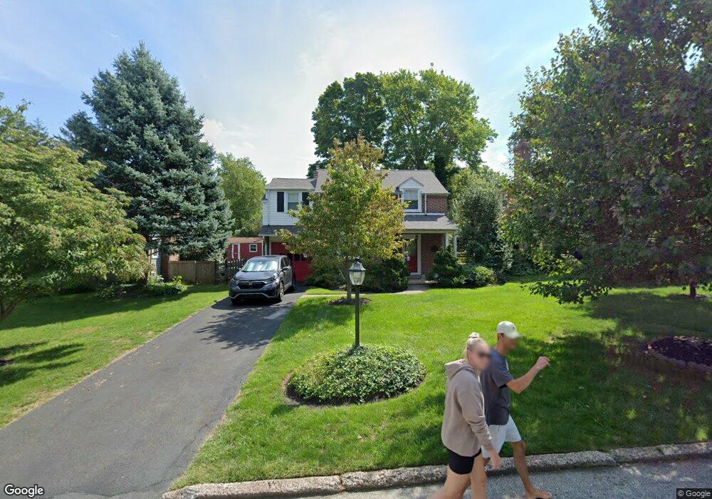
41 Chelfield Rd Glenside, PA 19038
Estimated Value: $451,935 - $485,000
3
Beds
2
Baths
1,507
Sq Ft
$310/Sq Ft
Est. Value
About This Home
This home is located at 41 Chelfield Rd, Glenside, PA 19038 and is currently estimated at $466,484, approximately $309 per square foot. 41 Chelfield Rd is a home located in Montgomery County with nearby schools including Elkins Park School, Cedarbrook Middle School, and Cheltenham High School.
Ownership History
Date
Name
Owned For
Owner Type
Purchase Details
Closed on
May 31, 2007
Sold by
White Annemarie F
Bought by
White Annemarie F and Annemarie F White Revoc Tr
Current Estimated Value
Purchase Details
Closed on
Jun 21, 2004
Sold by
Rittenhouse Charles E and Rittenhouse Mary L
Bought by
White Annemarie F
Purchase Details
Closed on
Sep 25, 1995
Sold by
Elwood John C and Elwood Margaret M
Bought by
Rittenhouse Charles E and Polaneczky Mary Louise
Create a Home Valuation Report for This Property
The Home Valuation Report is an in-depth analysis detailing your home's value as well as a comparison with similar homes in the area
Home Values in the Area
Average Home Value in this Area
Purchase History
| Date | Buyer | Sale Price | Title Company |
|---|---|---|---|
| White Annemarie F | -- | None Available | |
| White Annemarie F | $274,000 | -- | |
| Rittenhouse Charles E | $140,000 | T A Title Insurance Company |
Source: Public Records
Tax History
| Year | Tax Paid | Tax Assessment Tax Assessment Total Assessment is a certain percentage of the fair market value that is determined by local assessors to be the total taxable value of land and additions on the property. | Land | Improvement |
|---|---|---|---|---|
| 2025 | $9,004 | $134,810 | -- | -- |
| 2024 | $9,004 | $134,810 | -- | -- |
| 2023 | $8,903 | $134,810 | $0 | $0 |
| 2022 | $8,749 | $134,810 | $0 | $0 |
| 2021 | $8,510 | $134,810 | $0 | $0 |
| 2020 | $8,265 | $134,810 | $0 | $0 |
| 2019 | $8,100 | $134,810 | $0 | $0 |
Source: Public Records
Map
Nearby Homes
- 57 Chelfield Rd
- 776 Brooke Rd
- 65 Limekiln Pike
- 523 W Glenside Ave
- 208 Limekiln Pike
- 140 Linden Ave
- 336 Elm Ave
- 245 Linden Ave
- 3009 Limekiln Pike
- 910 Edann Rd
- 250 Logan Ave
- 2718 Hawthorne Rd
- 257 Girard Ave
- 705 Falcon Dr
- 2621 Hawthorne Rd
- 322 Logan Ave
- 332 Logan Ave
- 329 N Tyson Ave
- 461 Hamel Ave
- 358 Oak Rd
- 39 Chelfield Rd
- 43 Chelfield Rd
- 37 Chelfield Rd
- 45 Chelfield Rd
- 40 Chelfield Rd
- 44 Chelfield Rd
- 139 Carroll Ave
- 36 Chelfield Rd
- 35 Chelfield Rd
- 48 Chelfield Rd
- 125 Carroll Ave
- 141 Carroll Ave
- 32 Chelfield Rd
- 47 Chelfield Rd
- 33 Chelfield Rd
- 145 Carroll Ave
- 52 Chelfield Rd
- 49 Chelfield Rd
- 28 Chelfield Rd
- 147 Carroll Ave
Your Personal Tour Guide
Ask me questions while you tour the home.