
Seller's Agent in 2025
Team Correia
Keller Williams Realty - Merrimack
(978) 866-7360
1 in this area
135 Total Sales

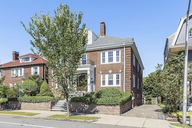
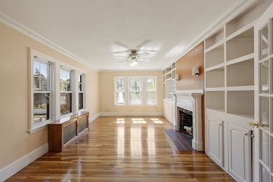
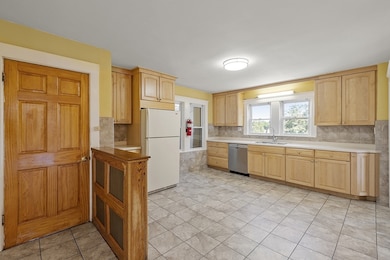
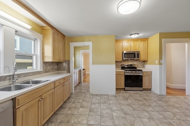
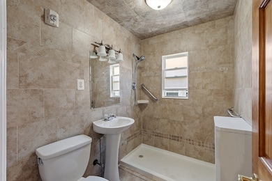
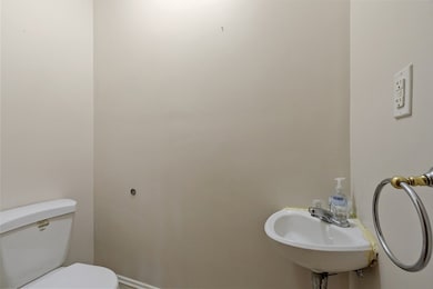
Large two-family home in the highly desirable Town of Belmont. The first unit offers 4 bedrooms, including a finished basement with one bedroom, kitchenette, full bath, and living room. The second unit features 4 bedrooms as well, with a large finished attic serving as the main bedroom with a half bath, laundry area, and walk-in closets. Recently professionally cleaned with beautifully refinished hardwood floors throughout, this home is move-in ready. Enjoy ample storage, a partially fenced-in backyard, and a paved driveway with parking for 3 cars. Perfect for investors or owner-occupants seeking a well-maintained, versatile property in a prime location. Don’t miss this must-see opportunity!
Last Agent to Sell the Property
Keller Williams Realty - Merrimack Listed on: 09/10/2025
| Date | Type | Sale Price | Title Company |
|---|---|---|---|
| Quit Claim Deed | $1,400,000 | -- | |
| Deed | $758,000 | -- | |
| Deed | $758,000 | -- | |
| Deed | $537,000 | -- |
| Date | Status | Loan Amount | Loan Type |
|---|---|---|---|
| Open | $1,675,000 | Purchase Money Mortgage | |
| Previous Owner | $720,100 | Purchase Money Mortgage | |
| Previous Owner | $490,000 | No Value Available | |
| Previous Owner | $483,300 | Purchase Money Mortgage |
| Date | Event | Price | List to Sale | Price per Sq Ft |
|---|---|---|---|---|
| 11/28/2025 11/28/25 | Sold | $1,400,000 | -9.7% | $323 / Sq Ft |
| 10/15/2025 10/15/25 | Pending | -- | -- | -- |
| 09/23/2025 09/23/25 | Price Changed | $1,550,000 | -3.1% | $358 / Sq Ft |
| 09/10/2025 09/10/25 | For Sale | $1,600,000 | -- | $370 / Sq Ft |
| Year | Tax Paid | Tax Assessment Tax Assessment Total Assessment is a certain percentage of the fair market value that is determined by local assessors to be the total taxable value of land and additions on the property. | Land | Improvement |
|---|---|---|---|---|
| 2025 | -- | $1,436,000 | $628,000 | $808,000 |
| 2024 | -- | $1,263,000 | $627,000 | $636,000 |
| 2023 | $0 | $1,202,000 | $628,000 | $574,000 |
| 2022 | $0 | $1,074,000 | $541,000 | $533,000 |
| 2021 | $0 | $1,146,000 | $703,000 | $443,000 |
| 2020 | $0 | $1,029,000 | $562,000 | $467,000 |
| 2019 | $0 | $898,000 | $390,000 | $508,000 |
| 2018 | $0 | $842,000 | $334,000 | $508,000 |
| 2017 | $0 | $802,000 | $298,000 | $504,000 |
Seller's Agent in 2025
Team Correia
Keller Williams Realty - Merrimack
(978) 866-7360
1 in this area
135 Total Sales
Seller Co-Listing Agent in 2025
Kevin Correia
Keller Williams Realty - Merrimack
(978) 692-3280
1 in this area
76 Total Sales
Buyer's Agent in 2025
Alex Walsh
Access
(781) 556-1703
1 in this area
513 Total Sales
Source: MLS Property Information Network (MLS PIN)
MLS Number: 73429212
APN: BELM-000022-000178
Disclaimer: Certain information contained herein is derived from information provided by parties other than Homes.com. All information provided is deemed reliable, but is not guaranteed to be accurate and should be independently verified.
![]() The property listing data and information, or the Images, set forth herein were provided to MLS Property Information Network, Inc. from third party sources, including sellers, lessors and public records, and were compiled by MLS Property Information Network, Inc. The property listing data and information, and the Images, are for the personal, non-commercial use of consumers having a good faith interest in purchasing or leasing listed properties of the type displayed to them and may not be used for any purpose other than to identify prospective properties which such consumers may have a good faith interest in purchasing or leasing. MLS Property Information Network, Inc. and its subscribers disclaim any and all representations and warranties as to the accuracy of the property listing data and information, or as to the accuracy of any of the Images, set forth herein.
The property listing data and information, or the Images, set forth herein were provided to MLS Property Information Network, Inc. from third party sources, including sellers, lessors and public records, and were compiled by MLS Property Information Network, Inc. The property listing data and information, and the Images, are for the personal, non-commercial use of consumers having a good faith interest in purchasing or leasing listed properties of the type displayed to them and may not be used for any purpose other than to identify prospective properties which such consumers may have a good faith interest in purchasing or leasing. MLS Property Information Network, Inc. and its subscribers disclaim any and all representations and warranties as to the accuracy of the property listing data and information, or as to the accuracy of any of the Images, set forth herein.
Ask me questions while you tour the home.