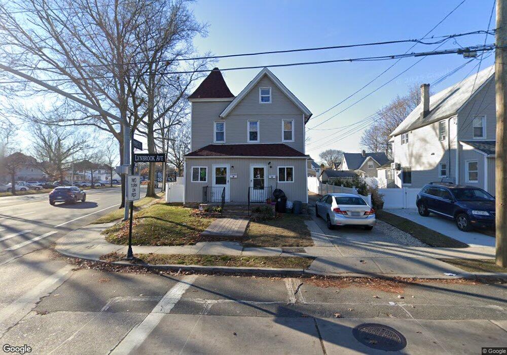
41 Lynbrook Ave Lynbrook, NY 11563
Estimated Value: $605,000 - $831,961
--
Bed
2
Baths
2,094
Sq Ft
$343/Sq Ft
Est. Value
About This Home
This home is located at 41 Lynbrook Ave, Lynbrook, NY 11563 and is currently estimated at $718,481, approximately $343 per square foot. 41 Lynbrook Ave is a home located in Nassau County with nearby schools including Lynbrook Senior High School and Our Lady Of Peace School.
Ownership History
Date
Name
Owned For
Owner Type
Purchase Details
Closed on
Jan 13, 2022
Sold by
Globe Drive Realty Llc
Bought by
Ramos Henry and Jaquez Yojeiry C
Current Estimated Value
Home Financials for this Owner
Home Financials are based on the most recent Mortgage that was taken out on this home.
Original Mortgage
$481,124
Outstanding Balance
$443,416
Interest Rate
3.11%
Mortgage Type
FHA
Estimated Equity
$275,065
Purchase Details
Closed on
Sep 22, 2020
Sold by
Mce Corp
Bought by
Globe Drive Realty Llc
Create a Home Valuation Report for This Property
The Home Valuation Report is an in-depth analysis detailing your home's value as well as a comparison with similar homes in the area
Home Values in the Area
Average Home Value in this Area
Purchase History
| Date | Buyer | Sale Price | Title Company |
|---|---|---|---|
| Ramos Henry | $490,000 | Fidelity National Title | |
| Globe Drive Realty Llc | $140,000 | None Available |
Source: Public Records
Mortgage History
| Date | Status | Borrower | Loan Amount |
|---|---|---|---|
| Open | Ramos Henry | $481,124 |
Source: Public Records
Tax History Compared to Growth
Tax History
| Year | Tax Paid | Tax Assessment Tax Assessment Total Assessment is a certain percentage of the fair market value that is determined by local assessors to be the total taxable value of land and additions on the property. | Land | Improvement |
|---|---|---|---|---|
| 2025 | $12,574 | $545 | $218 | $327 |
| 2024 | $1,188 | $545 | $218 | $327 |
| 2023 | $11,838 | $545 | $218 | $327 |
| 2022 | $11,838 | $545 | $218 | $327 |
| 2021 | $17,122 | $529 | $211 | $318 |
| 2020 | $11,064 | $715 | $466 | $249 |
| 2019 | $1,201 | $766 | $468 | $298 |
| 2018 | $9,777 | $817 | $0 | $0 |
| 2017 | $9,770 | $870 | $499 | $371 |
| 2016 | $11,028 | $870 | $499 | $371 |
| 2015 | $1,292 | $870 | $499 | $371 |
| 2014 | $1,292 | $870 | $499 | $371 |
| 2013 | $1,185 | $870 | $499 | $371 |
Source: Public Records
Map
Nearby Homes
- 45 Lynbrook Ave
- 54 Lynbrook Ave
- 266 Earle Ave
- 9 Watkins St
- 318 Vincent Ave
- 22 Devine St
- 92 Walnut St
- 9 Christabel St
- 45 Jefferson Ave
- 60 Hempstead Ave Unit 1H
- 60 Hempstead Ave Unit 1O
- 60 Hempstead Ave Unit 1J
- 60 Hempstead Ave Unit 1K
- 44 Jefferson Ave
- 80 Oak St
- 85 Edmund St
- 127 Hempstead Ave
- 89 Rolling St
- 5 Lawrence Ave
- 75 Noble St Unit 126
- 49 Lynbrook Ave
- 242 Denton Ave
- 248 Denton Ave
- 248 Denton Ave Unit 1
- 44 Lynbrook Ave
- 252 Denton Ave
- 53 Lynbrook Ave
- 50 Lynbrook Ave
- 50 Lynbrook Ave Unit 2nd fl
- 256 Denton Ave
- 57 Lynbrook Ave
- 25 Lynbrook Ave Unit 2nd Fl
- 25 Lynbrook Ave
- 24 Lynbrook Ave
- 260 Denton Ave
- 58 Lynbrook Ave
- 61 Lynbrook Ave
- 222 Denton Ave
- 17 Lynbrook Ave
- 264 Denton Ave