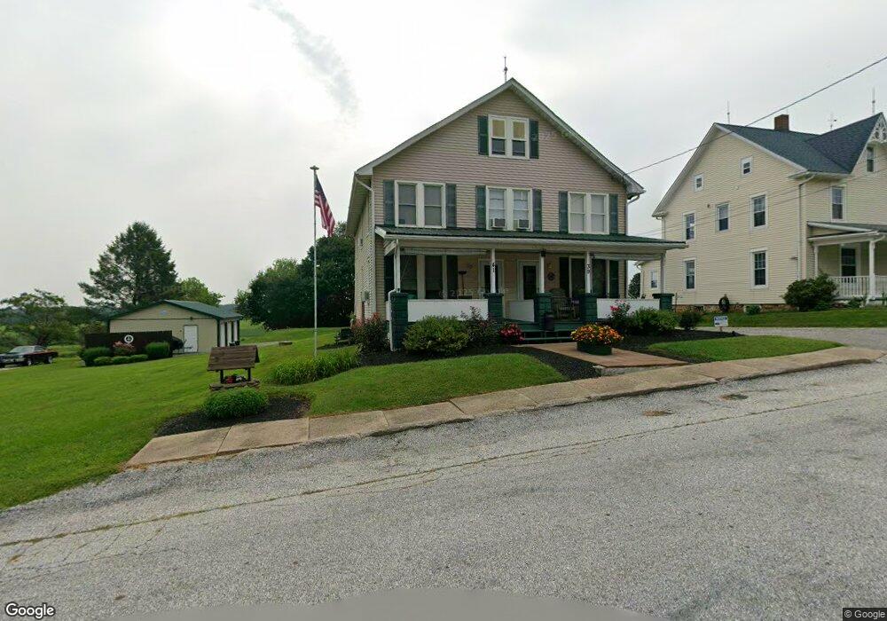
41 Morris Ave Fawn Grove, PA 17321
Estimated Value: $189,000 - $373,000
4
Beds
2
Baths
2,432
Sq Ft
$116/Sq Ft
Est. Value
About This Home
This home is located at 41 Morris Ave, Fawn Grove, PA 17321 and is currently estimated at $283,234, approximately $116 per square foot. 41 Morris Ave is a home located in York County with nearby schools including South Eastern Intermediate School, South Eastern Middle School, and Kennard-Dale High School.
Ownership History
Date
Name
Owned For
Owner Type
Purchase Details
Closed on
Jun 29, 2007
Sold by
Phillips Connie A and Tompkins David E
Bought by
Devoe James B
Current Estimated Value
Home Financials for this Owner
Home Financials are based on the most recent Mortgage that was taken out on this home.
Original Mortgage
$90,000
Interest Rate
6.24%
Mortgage Type
Purchase Money Mortgage
Purchase Details
Closed on
Nov 1, 1996
Bought by
Phillips Connie A
Create a Home Valuation Report for This Property
The Home Valuation Report is an in-depth analysis detailing your home's value as well as a comparison with similar homes in the area
Home Values in the Area
Average Home Value in this Area
Purchase History
| Date | Buyer | Sale Price | Title Company |
|---|---|---|---|
| Devoe James B | $165,000 | None Available | |
| Phillips Connie A | $110,000 | -- |
Source: Public Records
Mortgage History
| Date | Status | Borrower | Loan Amount |
|---|---|---|---|
| Closed | Devoe James B | $90,000 |
Source: Public Records
Tax History Compared to Growth
Tax History
| Year | Tax Paid | Tax Assessment Tax Assessment Total Assessment is a certain percentage of the fair market value that is determined by local assessors to be the total taxable value of land and additions on the property. | Land | Improvement |
|---|---|---|---|---|
| 2025 | $4,971 | $159,570 | $24,810 | $134,760 |
| 2024 | $4,971 | $159,570 | $24,810 | $134,760 |
| 2023 | $4,971 | $159,570 | $24,810 | $134,760 |
| 2022 | $4,971 | $159,570 | $24,810 | $134,760 |
| 2021 | $4,627 | $153,460 | $24,810 | $128,650 |
| 2020 | $4,627 | $153,460 | $24,810 | $128,650 |
| 2019 | $4,612 | $153,460 | $24,810 | $128,650 |
| 2018 | $4,612 | $153,460 | $24,810 | $128,650 |
| 2017 | $4,612 | $153,460 | $24,810 | $128,650 |
| 2016 | $0 | $153,460 | $24,810 | $128,650 |
| 2015 | -- | $153,460 | $24,810 | $128,650 |
| 2014 | -- | $153,460 | $24,810 | $128,650 |
Source: Public Records
Map
Nearby Homes
- 31 N Market St
- 1701 Scott Rd
- 387 Garvine Mill Rd
- 54 Mitchell Rd
- 2131 Channel Rd
- 238 Mitchell Rd
- 194 Cook Rd
- 257 Wiley Mill Rd
- 20 Carea Rd
- 2913 Whiteford Rd
- 267 Cook Rd
- 101 Saint Marys Rd
- 415 Saint Marys Rd
- 4816 Amos Rd
- 216 Meadow Trail
- Parcel 859 Neill Run Rd
- 397 Marsteller Rd
- 46 Corn Tassel Rd
- Lot C Bryansville Rd
- Lot 4 Ridge Rd