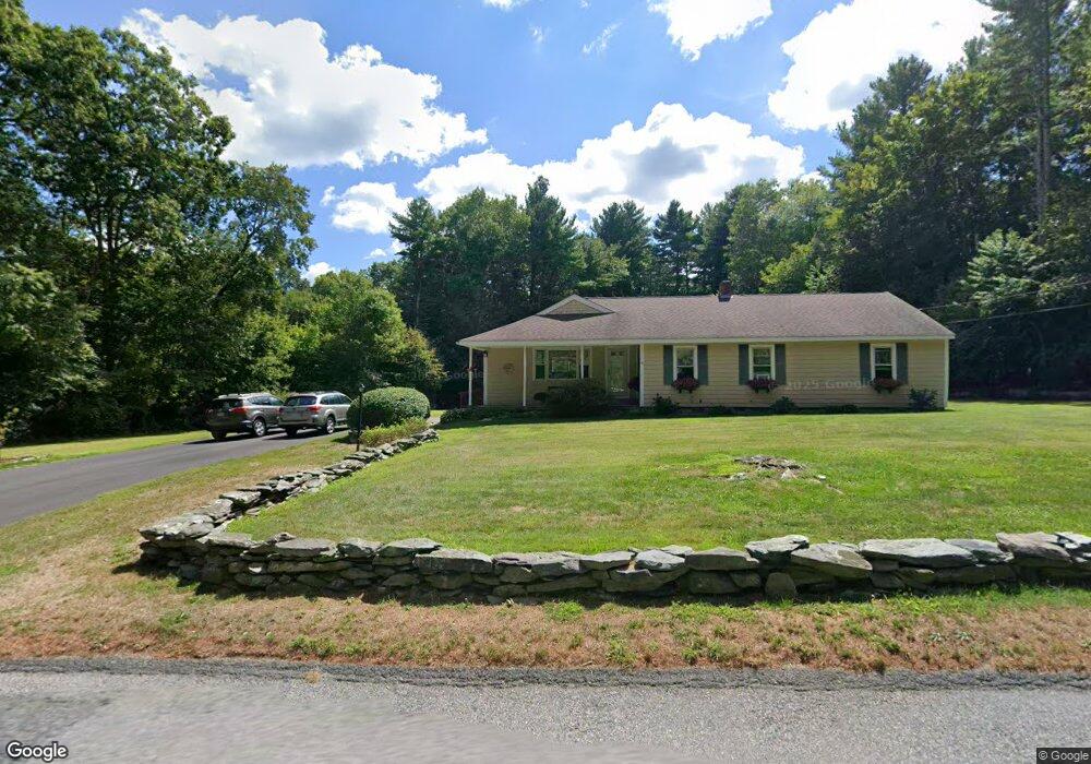
41 Murdock St Middleboro, MA 02346
Estimated Value: $487,000 - $552,000
3
Beds
1
Bath
1,448
Sq Ft
$353/Sq Ft
Est. Value
About This Home
This home is located at 41 Murdock St, Middleboro, MA 02346 and is currently estimated at $510,657, approximately $352 per square foot. 41 Murdock St is a home located in Plymouth County with nearby schools including Mary K. Goode Elementary School and Chamberlain International School.
Ownership History
Date
Name
Owned For
Owner Type
Purchase Details
Closed on
Sep 11, 1998
Sold by
Turner Timothy A and Turner Karen
Bought by
Mulcahy Mitchell J and Mulcahy Nancy J
Current Estimated Value
Purchase Details
Closed on
Nov 16, 1987
Sold by
Gertrude Bianchi Tr
Bought by
Murdock St Rt
Create a Home Valuation Report for This Property
The Home Valuation Report is an in-depth analysis detailing your home's value as well as a comparison with similar homes in the area
Home Values in the Area
Average Home Value in this Area
Purchase History
| Date | Buyer | Sale Price | Title Company |
|---|---|---|---|
| Mulcahy Mitchell J | $160,000 | -- | |
| Murdock St Rt | $175,000 | -- |
Source: Public Records
Mortgage History
| Date | Status | Borrower | Loan Amount |
|---|---|---|---|
| Open | Murdock St Rt | $120,000 | |
| Closed | Murdock St Rt | $25,000 | |
| Closed | Murdock St Rt | $25,000 | |
| Closed | Murdock St Rt | $116,400 |
Source: Public Records
Tax History Compared to Growth
Tax History
| Year | Tax Paid | Tax Assessment Tax Assessment Total Assessment is a certain percentage of the fair market value that is determined by local assessors to be the total taxable value of land and additions on the property. | Land | Improvement |
|---|---|---|---|---|
| 2025 | $5,336 | $397,900 | $169,200 | $228,700 |
| 2024 | $5,067 | $374,200 | $161,400 | $212,800 |
| 2023 | $4,768 | $334,800 | $161,400 | $173,400 |
| 2022 | $4,514 | $293,500 | $140,400 | $153,100 |
| 2021 | $4,395 | $270,100 | $123,000 | $147,100 |
| 2020 | $4,115 | $259,100 | $123,000 | $136,100 |
| 2019 | $3,882 | $250,800 | $123,000 | $127,800 |
| 2018 | $3,583 | $229,700 | $116,900 | $112,800 |
| 2017 | $3,521 | $223,300 | $112,900 | $110,400 |
| 2016 | $3,638 | $228,500 | $105,000 | $123,500 |
| 2015 | $3,383 | $214,400 | $105,000 | $109,400 |
Source: Public Records
Map
Nearby Homes
- 602 Hastings Rd Unit 602HAS
- 2602 Green St
- 2101 Pheasant Ln Unit 2101PHE
- 1903 Pheasant Ln Unit 1903PHE
- 227 Plymouth St
- 9 Woloski Park
- Lot 000 Summer St
- 2804 Island Dr
- 3509 Fox Run Unit 3509FOX
- 2404 Simmons Rd Unit 2404SIM
- 1305 Blueberry Cir
- 1606 Fox Run
- 2608 Oak Point Dr
- 31 Normans Way
- 50 Cross St
- 105 Plain St
- 145 Everett St
- 89 River St
- 0 Thompson St
- Lot B Thompson St
- 39 Murdock St
- 43 Murdock St
- 40 Murdock St
- 35 Murdock St
- 46 Murdock St
- 36 Murdock St
- 31 Murdock St
- 34 Murdock St
- 32 Murdock St
- 29 Murdock St
- 51 Murdock St
- 27 Murdock St
- 30 Murdock St
- 5 Edgewater Ln
- 169 Rivers Edge Dr
- 25 Murdock St
- 136 River's Edge Dr
- 26 Rivers Edge Dr
- 163 Rivers Edge Dr
- 110 Summer St