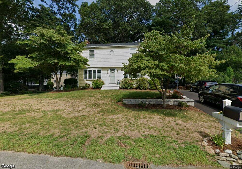
41 Oak Crest Dr North Attleboro, MA 02760
North Attleboro NeighborhoodEstimated Value: $599,812 - $663,000
4
Beds
2
Baths
1,568
Sq Ft
$404/Sq Ft
Est. Value
About This Home
This home is located at 41 Oak Crest Dr, North Attleboro, MA 02760 and is currently estimated at $633,203, approximately $403 per square foot. 41 Oak Crest Dr is a home located in Bristol County with nearby schools including North Attleboro High School, Cadence Academy Preschool - North Attleborough, and Bishop Feehan High School.
Ownership History
Date
Name
Owned For
Owner Type
Purchase Details
Closed on
Jan 15, 2003
Sold by
Flanagan William J and Flanagan Marcia E
Bought by
Sutula Robert E and Cryan Sheila M
Current Estimated Value
Home Financials for this Owner
Home Financials are based on the most recent Mortgage that was taken out on this home.
Original Mortgage
$263,700
Outstanding Balance
$113,808
Interest Rate
6.18%
Mortgage Type
Purchase Money Mortgage
Estimated Equity
$519,395
Create a Home Valuation Report for This Property
The Home Valuation Report is an in-depth analysis detailing your home's value as well as a comparison with similar homes in the area
Home Values in the Area
Average Home Value in this Area
Purchase History
| Date | Buyer | Sale Price | Title Company |
|---|---|---|---|
| Sutula Robert E | $293,000 | -- |
Source: Public Records
Mortgage History
| Date | Status | Borrower | Loan Amount |
|---|---|---|---|
| Open | Sutula Robert E | $263,700 |
Source: Public Records
Tax History Compared to Growth
Tax History
| Year | Tax Paid | Tax Assessment Tax Assessment Total Assessment is a certain percentage of the fair market value that is determined by local assessors to be the total taxable value of land and additions on the property. | Land | Improvement |
|---|---|---|---|---|
| 2025 | $5,115 | $433,800 | $149,100 | $284,700 |
| 2024 | $5,085 | $440,600 | $149,100 | $291,500 |
| 2023 | $5,044 | $394,400 | $155,600 | $238,800 |
| 2022 | $4,789 | $343,800 | $149,100 | $194,700 |
| 2021 | $4,671 | $327,300 | $149,100 | $178,200 |
| 2020 | $4,048 | $322,300 | $149,100 | $173,200 |
| 2019 | $4,427 | $310,900 | $135,600 | $175,300 |
| 2018 | $4,092 | $291,800 | $135,600 | $156,200 |
| 2017 | $3,858 | $291,800 | $135,600 | $156,200 |
| 2016 | $3,904 | $295,300 | $157,100 | $138,200 |
| 2015 | $3,861 | $293,800 | $163,700 | $130,100 |
| 2014 | $3,641 | $275,000 | $143,700 | $131,300 |
Source: Public Records
Map
Nearby Homes
- 16 Raymond Hall Dr
- 116 George St
- 15 Old Wood Rd
- 10 Sleepy Hollow Cir
- 11 Landry Ave
- 57 Vine St
- 28 Messenger St
- Lot 5 Jeffrey Dr
- 2 George St Unit C
- 9 Sunnyside Dr Unit 9
- Lot 2 Jeffrey Dr
- 33 Dublin Way
- 166 E Bacon St Unit 4
- 12 Houde St
- 2 Woodridge St Unit 2
- 115 Westfield Dr
- 24 Red Coat Ln
- 4 Garden Ln
- 3 Serengeti Dr
- 52 George St Unit B
- 42 Woodcrest Rd
- 50 Woodcrest Rd
- 46 Oak Crest Dr
- 53 Oak Crest Dr
- 27 Oak Crest Dr
- 34 Oak Crest Dr
- 30 Woodcrest Rd
- 56 Oak Crest Dr
- 60 Woodcrest Rd
- 16 Saint James Rd
- 45 Woodcrest Rd
- 37 Woodcrest Rd
- 22 Oak Crest Dr
- 65 Oak Crest Dr
- 18 Woodcrest Rd
- 15 Saint James Rd
- 55 Woodcrest Rd
- 68 Woodcrest Rd
- 27 Woodcrest Rd
- 68 Oak Crest Dr