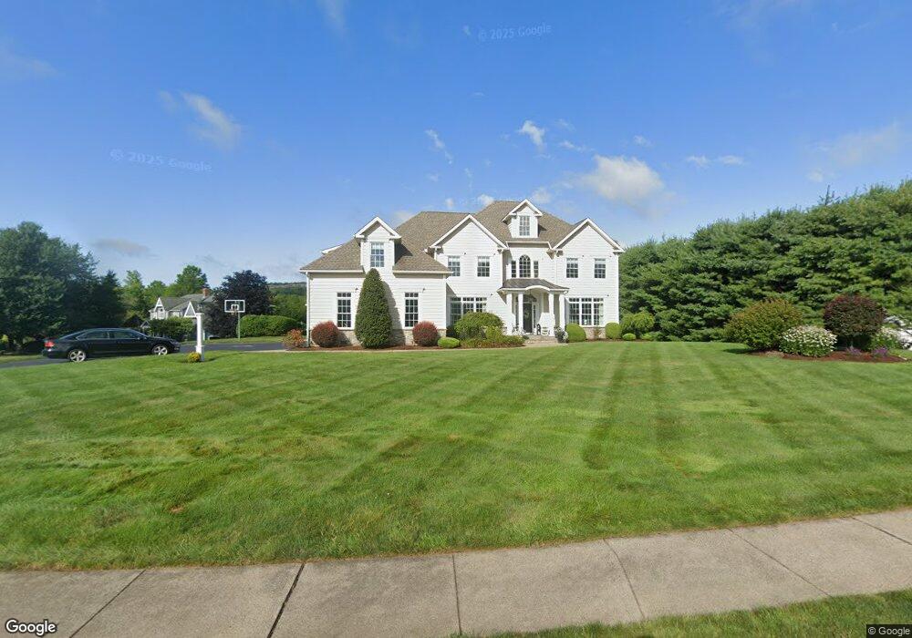
41 Olander Ln Middletown, CT 06457
Highland NeighborhoodEstimated Value: $735,000 - $902,000
4
Beds
4
Baths
4,511
Sq Ft
$185/Sq Ft
Est. Value
About This Home
This home is located at 41 Olander Ln, Middletown, CT 06457 and is currently estimated at $833,353, approximately $184 per square foot. 41 Olander Ln is a home with nearby schools including Moody School and Middletown High School.
Ownership History
Date
Name
Owned For
Owner Type
Purchase Details
Closed on
May 11, 2009
Sold by
Fitzner William and Fitzner Kim
Bought by
Stevens Julie A
Current Estimated Value
Purchase Details
Closed on
Jun 1, 2007
Sold by
Diamonte Robin L and Iannucci Lori A
Bought by
Fitzner William and Fitzner Kim
Create a Home Valuation Report for This Property
The Home Valuation Report is an in-depth analysis detailing your home's value as well as a comparison with similar homes in the area
Home Values in the Area
Average Home Value in this Area
Purchase History
| Date | Buyer | Sale Price | Title Company |
|---|---|---|---|
| Stevens Julie A | $210,000 | -- | |
| Fitzner William | $220,000 | -- |
Source: Public Records
Mortgage History
| Date | Status | Borrower | Loan Amount |
|---|---|---|---|
| Open | Fitzner William | $490,000 |
Source: Public Records
Tax History
| Year | Tax Paid | Tax Assessment Tax Assessment Total Assessment is a certain percentage of the fair market value that is determined by local assessors to be the total taxable value of land and additions on the property. | Land | Improvement |
|---|---|---|---|---|
| 2025 | $16,507 | $490,000 | $85,760 | $404,240 |
| 2024 | $15,651 | $490,000 | $85,760 | $404,240 |
| 2023 | $14,722 | $490,000 | $85,760 | $404,240 |
| 2022 | $17,509 | $466,700 | $62,750 | $403,950 |
| 2021 | $17,316 | $462,680 | $62,750 | $399,930 |
| 2020 | $17,343 | $462,680 | $62,750 | $399,930 |
| 2019 | $17,435 | $462,680 | $62,750 | $399,930 |
| 2018 | $16,816 | $462,680 | $62,750 | $399,930 |
| 2017 | $15,774 | $444,960 | $81,420 | $363,540 |
| 2016 | $15,468 | $444,960 | $81,420 | $363,540 |
| 2015 | $14,134 | $415,510 | $81,420 | $334,090 |
| 2014 | $14,138 | $415,510 | $81,420 | $334,090 |
Source: Public Records
Map
Nearby Homes
- 301 Bell St
- 0 Bell St Unit 24149149
- 0 Country Club Rd and Massa Tom Rd Rd E
- 95 S Ridge Ln Unit FGL-2
- 95 S Ridge Ln Unit D101
- 1655 N Colony Rd Unit 5001
- 1655 N Colony Rd Unit 17
- 1950 N Broad St Unit 27
- 116 Silver Island Way Unit 116
- 42 Anton Ln
- 601 Higby Rd
- 602 Higby Rd
- 281 Briarwood Ln
- 436 & 444 Preston Ave
- 1371 Old North Colony Rd
- 691 Baldwin Ave
- 180 Carriage Crossing Ln Unit 180
- 301 Carriage Crossing Ln Unit 301
- 118 Carriage Crossing Ln
- 285 Carriage Crossing Ln Unit 285