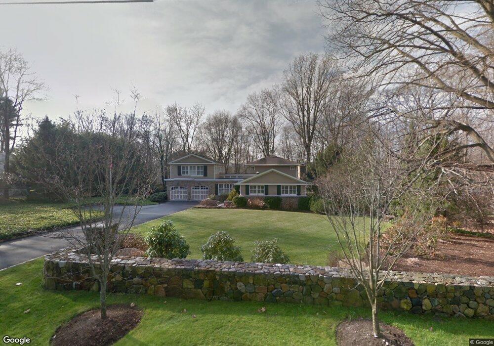
41 Parish Rd New Canaan, CT 06840
Estimated Value: $1,750,000 - $2,796,000
3
Beds
5
Baths
3,729
Sq Ft
$623/Sq Ft
Est. Value
About This Home
This home is located at 41 Parish Rd, New Canaan, CT 06840 and is currently estimated at $2,323,012, approximately $622 per square foot. 41 Parish Rd is a home located in Fairfield County with nearby schools including West Elementary School, Saxe Middle School, and New Canaan High School.
Ownership History
Date
Name
Owned For
Owner Type
Purchase Details
Closed on
Aug 2, 1995
Sold by
Leedy Lynn A
Bought by
Bentley Judy S and Bentley David W
Current Estimated Value
Home Financials for this Owner
Home Financials are based on the most recent Mortgage that was taken out on this home.
Original Mortgage
$203,150
Interest Rate
7.48%
Mortgage Type
Unknown
Create a Home Valuation Report for This Property
The Home Valuation Report is an in-depth analysis detailing your home's value as well as a comparison with similar homes in the area
Home Values in the Area
Average Home Value in this Area
Purchase History
| Date | Buyer | Sale Price | Title Company |
|---|---|---|---|
| Bentley Judy S | $595,000 | -- |
Source: Public Records
Mortgage History
| Date | Status | Borrower | Loan Amount |
|---|---|---|---|
| Closed | Bentley Judy S | $203,150 | |
| Previous Owner | Bentley Judy S | $200,000 |
Source: Public Records
Tax History Compared to Growth
Tax History
| Year | Tax Paid | Tax Assessment Tax Assessment Total Assessment is a certain percentage of the fair market value that is determined by local assessors to be the total taxable value of land and additions on the property. | Land | Improvement |
|---|---|---|---|---|
| 2025 | $19,037 | $1,140,650 | $700,000 | $440,650 |
| 2024 | $18,410 | $1,140,650 | $700,000 | $440,650 |
| 2023 | $16,187 | $854,630 | $606,620 | $248,010 |
| 2022 | $15,700 | $854,630 | $606,620 | $248,010 |
| 2021 | $15,520 | $854,630 | $606,620 | $248,010 |
| 2020 | $15,520 | $854,630 | $606,620 | $248,010 |
| 2019 | $15,588 | $854,630 | $606,620 | $248,010 |
| 2018 | $17,571 | $1,036,000 | $624,120 | $411,880 |
| 2017 | $17,270 | $1,036,000 | $624,120 | $411,880 |
| 2016 | $16,897 | $1,036,000 | $624,120 | $411,880 |
| 2015 | $17,156 | $1,036,000 | $624,120 | $411,880 |
| 2014 | $16,099 | $1,036,000 | $624,120 | $411,880 |
Source: Public Records
Map
Nearby Homes
- 470 Frogtown Rd Unit Lot 1
- 197 Park St Unit 13
- 317 Park St
- 202 Weed St
- 474 Ponus Ridge
- 15 Burtis Ave Unit Townhome D
- 15 Burtis Ave Unit West Penthouse B
- 15 Burtis Ave Unit East Penthouse C
- 15 Burtis Ave Unit Townhome A
- 15 Burtis Ave Unit East Plaza 203
- 42 Forest St Unit A
- 50 Harrison Ave
- 276 Greenley Rd
- 25 Gower Rd
- 354 South Ave
- 60 East Ave
- 298 Greenley Rd
- 64 East Ave
- 180 Summer St
- 204 Parade Hill Rd