41 Park St Wilmington, MA 01887
Estimated Value: $632,000 - $680,000
3
Beds
1
Bath
1,188
Sq Ft
$559/Sq Ft
Est. Value
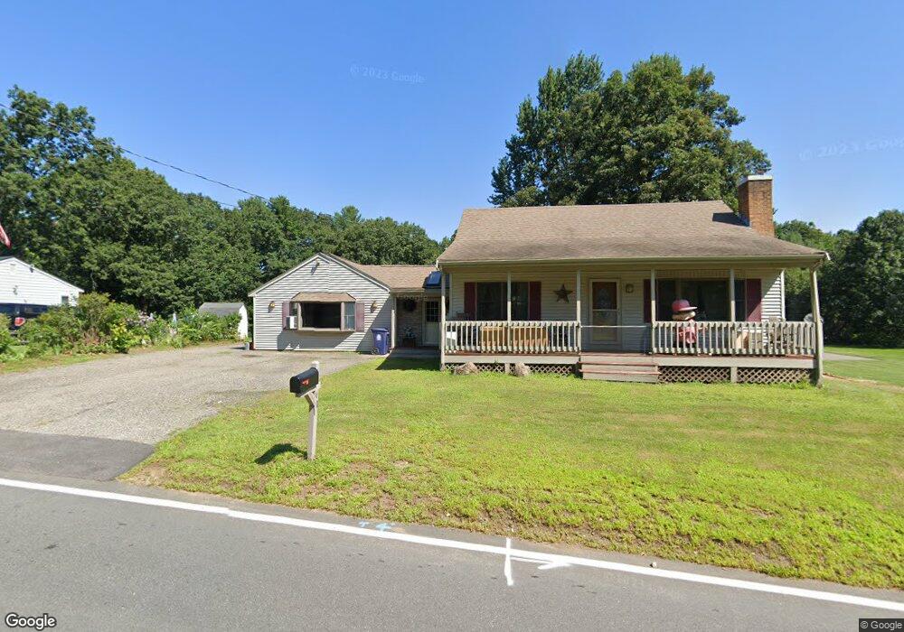
About This Home
This home is located at 41 Park St, Wilmington, MA 01887 and is currently estimated at $664,270, approximately $559 per square foot. 41 Park St is a home located in Middlesex County with nearby schools including Wilmington Middle School, Wilmington High School, and N Reading Knowledge Beginnings.
Ownership History
Date
Name
Owned For
Owner Type
Purchase Details
Closed on
Jan 26, 2021
Sold by
Miller Thomas A and Miller Medora M
Bought by
Miller 2021 T
Current Estimated Value
Purchase Details
Closed on
Jun 1, 1989
Sold by
Miller Thomas
Bought by
Miller Thomas
Create a Home Valuation Report for This Property
The Home Valuation Report is an in-depth analysis detailing your home's value as well as a comparison with similar homes in the area
Home Values in the Area
Average Home Value in this Area
Purchase History
| Date | Buyer | Sale Price | Title Company |
|---|---|---|---|
| Miller 2021 T | -- | None Available | |
| Miller Thomas | $172,000 | -- |
Source: Public Records
Mortgage History
| Date | Status | Borrower | Loan Amount |
|---|---|---|---|
| Previous Owner | Miller Thomas | $152,500 | |
| Previous Owner | Miller Thomas | $60,000 |
Source: Public Records
Tax History Compared to Growth
Tax History
| Year | Tax Paid | Tax Assessment Tax Assessment Total Assessment is a certain percentage of the fair market value that is determined by local assessors to be the total taxable value of land and additions on the property. | Land | Improvement |
|---|---|---|---|---|
| 2025 | $6,245 | $545,400 | $276,800 | $268,600 |
| 2024 | $5,994 | $524,400 | $276,800 | $247,600 |
| 2023 | $5,815 | $487,000 | $251,700 | $235,300 |
| 2022 | $5,526 | $424,100 | $209,700 | $214,400 |
| 2021 | $5,540 | $400,300 | $190,600 | $209,700 |
| 2020 | $5,287 | $389,300 | $190,600 | $198,700 |
| 2019 | $5,242 | $381,200 | $181,500 | $199,700 |
| 2018 | $4,701 | $339,000 | $172,900 | $166,100 |
| 2017 | $4,701 | $325,300 | $171,100 | $154,200 |
| 2016 | $4,616 | $315,500 | $163,000 | $152,500 |
| 2015 | $4,432 | $308,400 | $163,000 | $145,400 |
| 2014 | $4,114 | $288,900 | $155,300 | $133,600 |
Source: Public Records
Map
Nearby Homes
- 42 High St
- 9 Marie Dr
- 401 Middlesex Ave
- 7 W Village Dr
- 5 Flynn Way
- 11 Cedarcrest Rd
- 260 Martins Landing Unit 103
- 240 Martins Landing Unit 409
- 240 Martins Landing Unit 201
- 260 Martins Landing Unit 508
- 3 Catherine Ave
- Lincoln Plan at Martins Landing
- Ivywood Plan at Martins Landing
- Hayden Plan at Martins Landing
- Franklin Plan at Martins Landing
- Claremont Plan at Martins Landing
- Magnolia Plan at Martins Landing
- Jameson Plan at Martins Landing
- 300 Martins Landing Unit 107
- 250 Martins Landing Unit 213