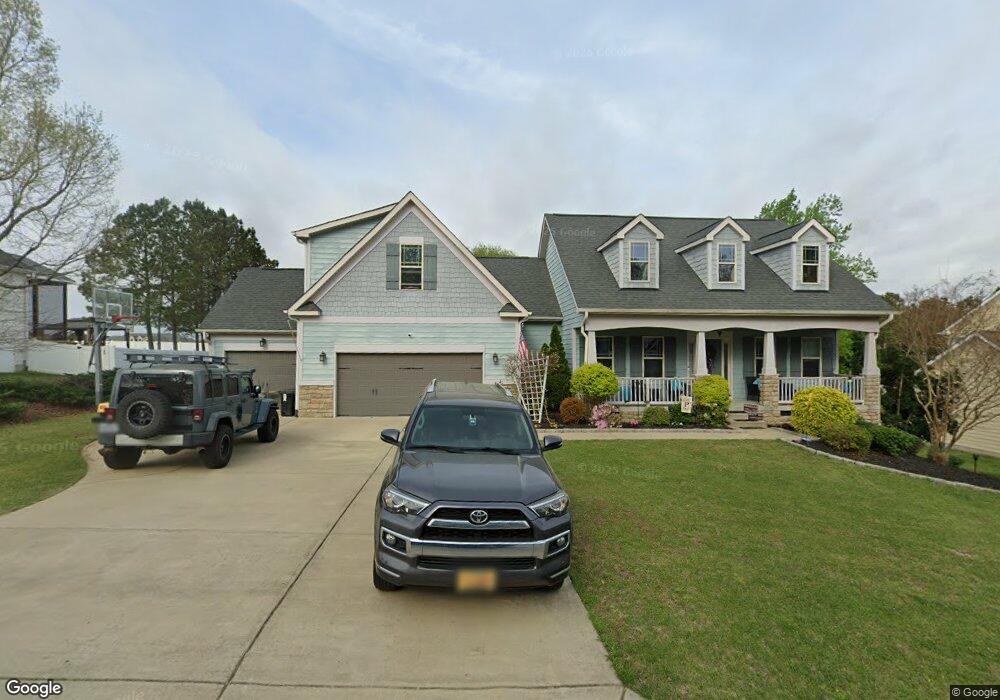
41 Pointer Trail Garner, NC 27529
Cleveland NeighborhoodEstimated Value: $481,140 - $526,000
4
Beds
3
Baths
2,726
Sq Ft
$186/Sq Ft
Est. Value
About This Home
This home is located at 41 Pointer Trail, Garner, NC 27529 and is currently estimated at $506,535, approximately $185 per square foot. 41 Pointer Trail is a home located in Johnston County with nearby schools including West View Elementary School, Cleveland Middle School, and West Johnston High School.
Ownership History
Date
Name
Owned For
Owner Type
Purchase Details
Closed on
Dec 2, 2015
Sold by
Hardee Lisa M and Hardee Joseph
Bought by
Pearson Donna and Pearson James
Current Estimated Value
Home Financials for this Owner
Home Financials are based on the most recent Mortgage that was taken out on this home.
Original Mortgage
$285,510
Outstanding Balance
$223,888
Interest Rate
3.62%
Mortgage Type
FHA
Estimated Equity
$282,647
Purchase Details
Closed on
May 29, 2015
Sold by
Carroll Construction Homes Inc
Bought by
Hardee Lisa Morris
Purchase Details
Closed on
Feb 26, 2015
Sold by
Dj 4042 Inc
Bought by
Carroll Construction Homes Inc
Home Financials for this Owner
Home Financials are based on the most recent Mortgage that was taken out on this home.
Original Mortgage
$216,000
Interest Rate
3.75%
Mortgage Type
Construction
Create a Home Valuation Report for This Property
The Home Valuation Report is an in-depth analysis detailing your home's value as well as a comparison with similar homes in the area
Home Values in the Area
Average Home Value in this Area
Purchase History
| Date | Buyer | Sale Price | Title Company |
|---|---|---|---|
| Pearson Donna | $295,000 | None Available | |
| Hardee Lisa Morris | $287,000 | None Available | |
| Carroll Construction Homes Inc | $53,000 | None Available |
Source: Public Records
Mortgage History
| Date | Status | Borrower | Loan Amount |
|---|---|---|---|
| Open | Pearson Donna | $285,510 | |
| Previous Owner | Carroll Construction Homes Inc | $216,000 |
Source: Public Records
Tax History Compared to Growth
Tax History
| Year | Tax Paid | Tax Assessment Tax Assessment Total Assessment is a certain percentage of the fair market value that is determined by local assessors to be the total taxable value of land and additions on the property. | Land | Improvement |
|---|---|---|---|---|
| 2025 | $3,080 | $485,070 | $70,000 | $415,070 |
| 2024 | $2,526 | $311,840 | $50,000 | $261,840 |
| 2023 | $2,440 | $311,840 | $50,000 | $261,840 |
| 2022 | $2,565 | $311,840 | $50,000 | $261,840 |
| 2021 | $2,565 | $311,840 | $50,000 | $261,840 |
| 2020 | $2,596 | $311,840 | $50,000 | $261,840 |
| 2019 | $2,596 | $311,840 | $50,000 | $261,840 |
| 2018 | $2,309 | $270,900 | $44,000 | $226,900 |
| 2017 | $2,309 | $270,900 | $44,000 | $226,900 |
| 2016 | $2,309 | $270,900 | $44,000 | $226,900 |
| 2015 | -- | $83,000 | $44,000 | $39,000 |
Source: Public Records
Map
Nearby Homes
- 39 Beau Dr
- 49 Dandy Flush Ct
- 742 Adams Point Dr
- 648 Fieldtrial Cir
- 58 Trailblazer Ln
- 58 Larkwood Ln
- 75 Fawn Hill Ct
- 181 Fawn Hill Ct
- 113 Hogan Dr
- 866 Black Angus Dr
- 562 Pierce Rd
- 48 Banbury Ct
- 111 Artic Cir
- Lot 2a S Shiloh Rd
- 368 Artic Cir
- 50 Linden Ct
- 114 Boone Trail
- 11114 Cleveland Rd
- 15 Crest Cir
- 390 Blair Dr