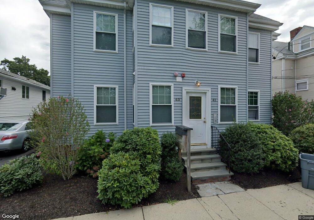
41 Port Norfolk St Unit 43 Dorchester, MA 02122
Neponset-Port Norfolk NeighborhoodEstimated Value: $584,073 - $633,000
2
Beds
1
Bath
1,065
Sq Ft
$569/Sq Ft
Est. Value
About This Home
This home is located at 41 Port Norfolk St Unit 43, Dorchester, MA 02122 and is currently estimated at $605,518, approximately $568 per square foot. 41 Port Norfolk St Unit 43 is a home located in Suffolk County with nearby schools including Neighborhood House Charter School, St Brendan School, and Quincy Catholic Academy.
Create a Home Valuation Report for This Property
The Home Valuation Report is an in-depth analysis detailing your home's value as well as a comparison with similar homes in the area
Home Values in the Area
Average Home Value in this Area
Mortgage History
| Date | Status | Borrower | Loan Amount |
|---|---|---|---|
| Closed | Sherwin Andrew M | $452,300 | |
| Closed | Duggan Kyle | $386,100 | |
| Closed | Bresnahan Michael P | $39,300 | |
| Closed | Franey Christina M | $227,000 |
Source: Public Records
Tax History Compared to Growth
Tax History
| Year | Tax Paid | Tax Assessment Tax Assessment Total Assessment is a certain percentage of the fair market value that is determined by local assessors to be the total taxable value of land and additions on the property. | Land | Improvement |
|---|---|---|---|---|
| 2025 | $6,286 | $542,800 | $0 | $542,800 |
| 2024 | $5,493 | $503,900 | $0 | $503,900 |
| 2023 | $5,254 | $489,200 | $0 | $489,200 |
| 2022 | $5,020 | $461,400 | $0 | $461,400 |
| 2021 | $4,780 | $448,000 | $0 | $448,000 |
| 2020 | $4,558 | $431,600 | $0 | $431,600 |
| 2019 | $4,291 | $407,100 | $0 | $407,100 |
| 2018 | $3,951 | $377,000 | $0 | $377,000 |
| 2017 | $3,663 | $345,900 | $0 | $345,900 |
| 2016 | $3,556 | $323,300 | $0 | $323,300 |
| 2015 | $3,447 | $284,600 | $0 | $284,600 |
| 2014 | $3,285 | $261,100 | $0 | $261,100 |
Source: Public Records
Map
Nearby Homes
- 7 Bloomington St
- 378 Neponset Ave
- 36 Mckone St
- 36 Mckone St Unit 2
- 36 Mckone St Unit 1
- 4 Chickatawbut St
- 56 Coffey St Unit 7
- 49 Coffey St Unit B
- 48 Coffey St Unit 10A
- 158 Quincy Shore Dr Unit 78
- 4 Payne St Unit THREE
- 4 Payne St Unit One
- 60 Houghton St Unit 62
- 148 Quincy Shore Dr Unit 30
- 221 Victory Rd Unit 221
- 30 N Munroe Terrace Unit 2
- 133 Commander Shea Blvd Unit 215
- 133 Commander Shea Blvd Unit 614
- 133 Commander Shea Blvd Unit 315
- 34 Houghton St
- 41 Port Norfolk St Unit 43
- 41 Port Norfolk St Unit 43
- 41 Port Norfolk St Unit 43
- 41 Port Norfolk St Unit 2
- 41 Port Norfolk St
- 41 Port Norfolk St Unit 1R
- 41-43 Port Norfolk St Unit 3
- 41-43 Port Norfolk St Unit 1L
- 41-43 Port Norfolk St Unit 2
- 41-43 Port Norfolk St Unit 1R
- 37 Port Norfolk St
- 49 Port Norfolk St
- 35 Port Norfolk St
- 35 Port Norfolk St Unit 2
- 35 Port Norfolk St Unit 1
- 46 Port Norfolk St Unit 1
- 46 Port Norfolk St
- 46 Port Norfolk St Unit 2
- 46 Port Norfolk St Unit 3
- 51 Port Norfolk St